- Attractions
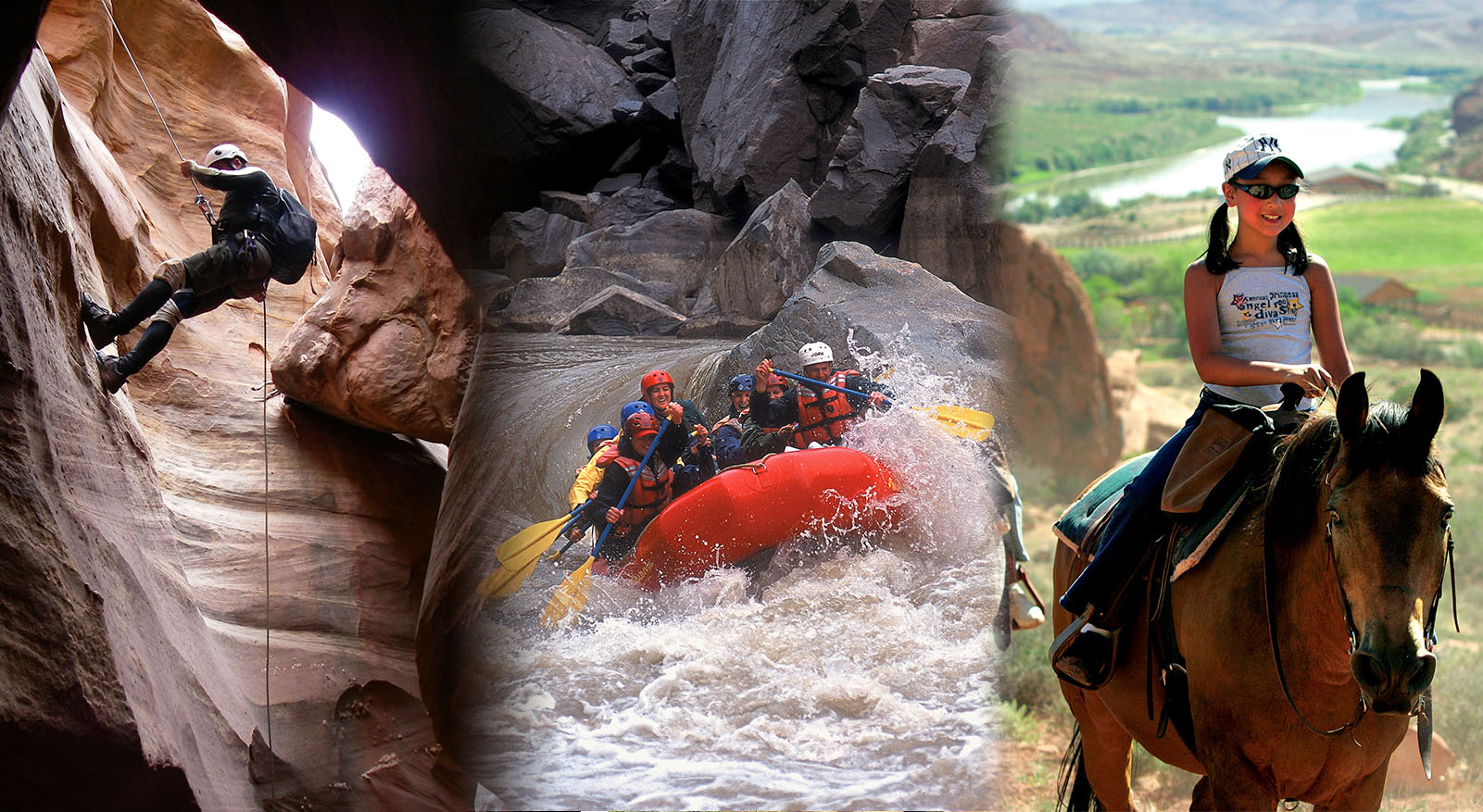
- Activities
- Lodging + Campgrounds
- Area Info
- Services
- Transportation

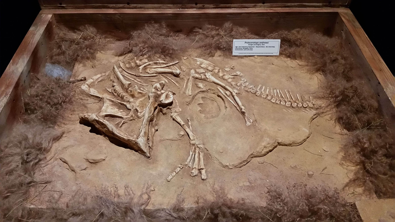
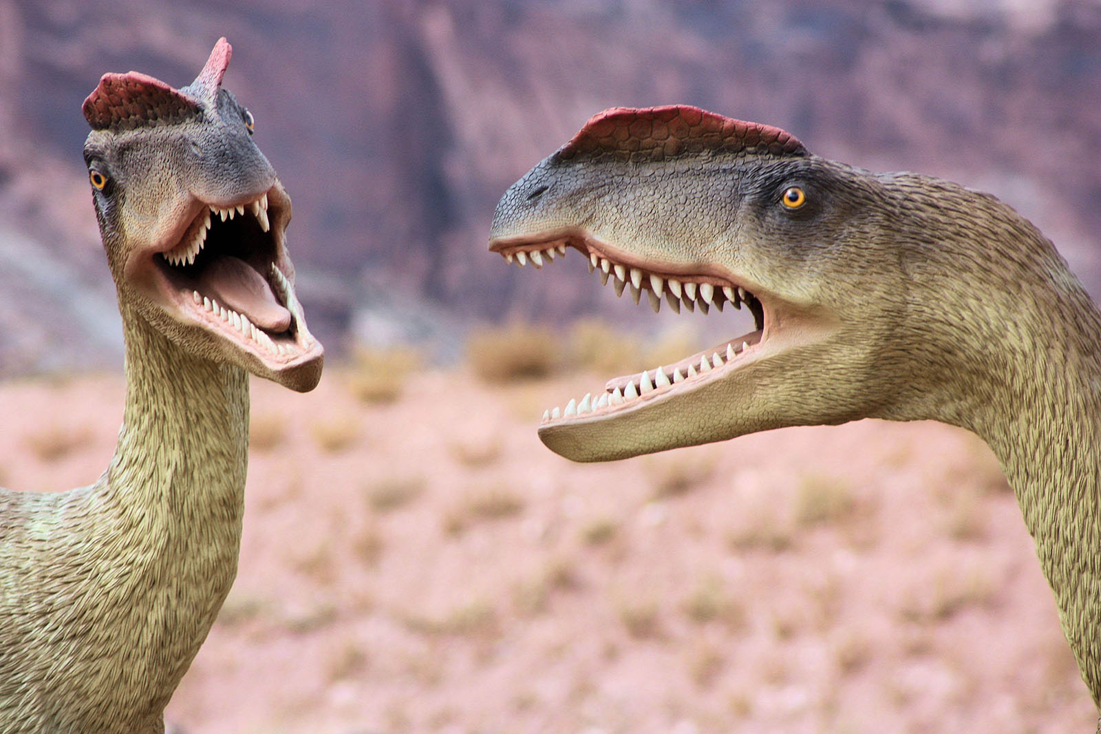
Dinosaur Museums and Hikes
With so many dinosaur resources in one place, Moab is the perfect place to design your own Family Dinosaur Field Trip!y
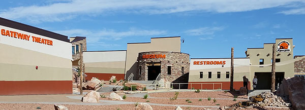
Start your Dinosaur Field Trip in downtown Moab, at the Museum of Moab. Check out a full cast skeleton of Gastonia, one of the armored dinosaurs that lived in this area during the Early Cretaceous. The museum also features numerous dinosaur displays, including a cast of the leg of the terrifying Utahraptor.
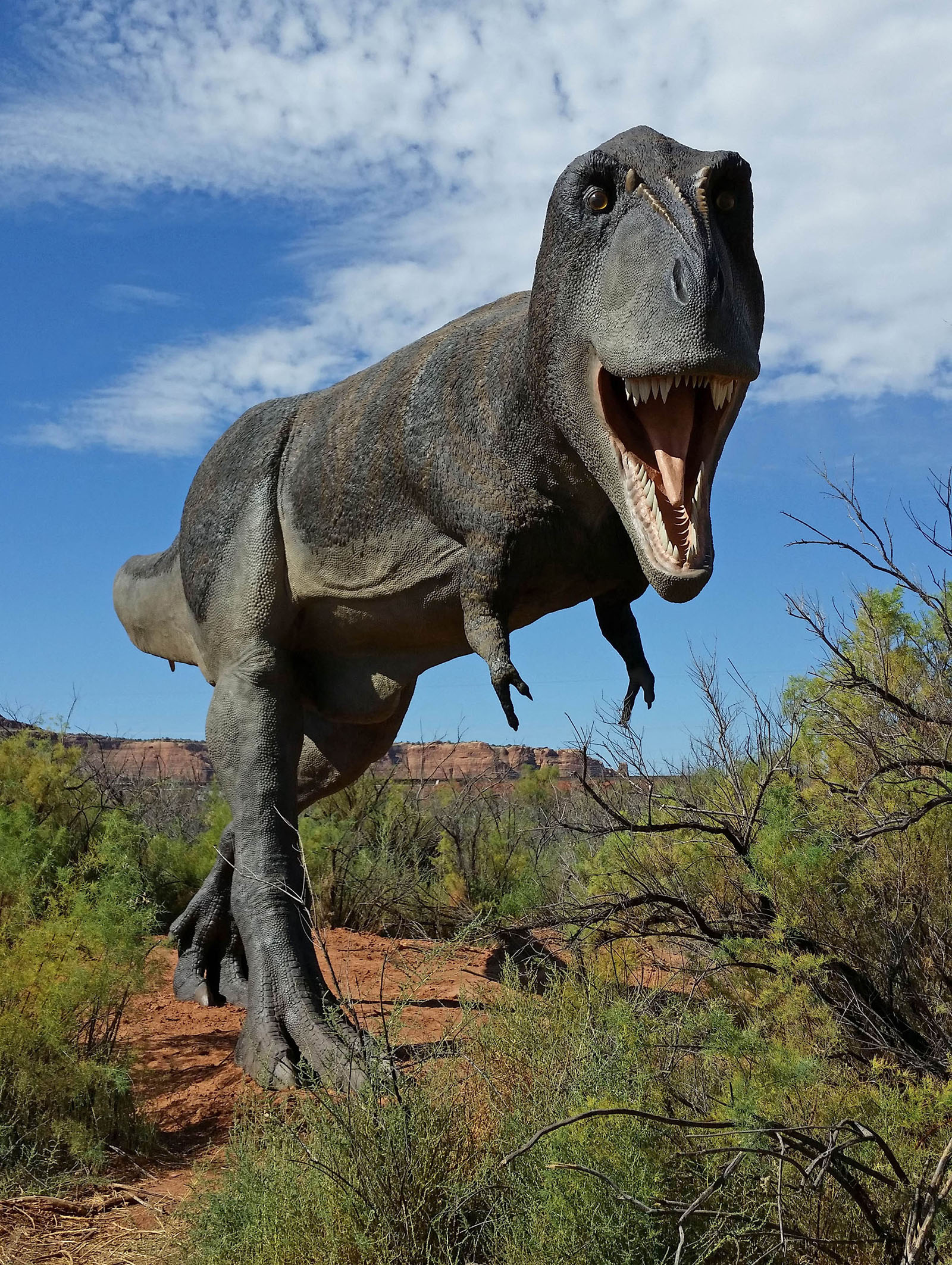
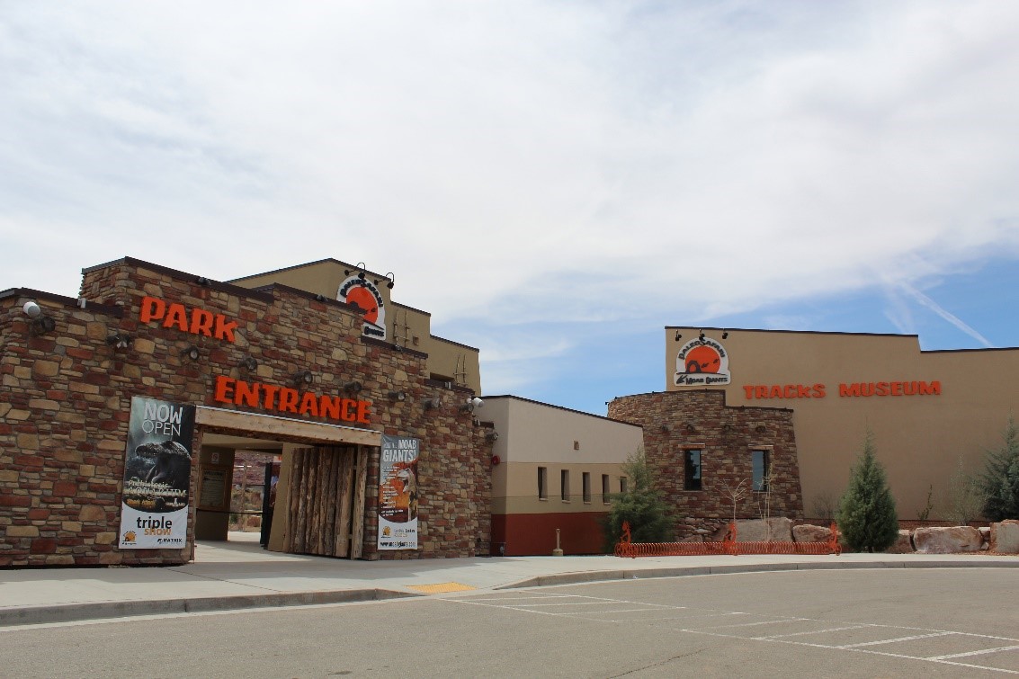
Continue your journey at Paleosafari Moab Giants, where you can journey back through time with a 3D cinema introducing you to the prehistoric world of dinosaurs. You can also make your own tracks on a half mile hiking trail populated with state-of the art life-size dinosaurs! The Tracks Museum features interactive learning touch screens, games to play, and visually stunning exhibits that not only fascinate, but educate.
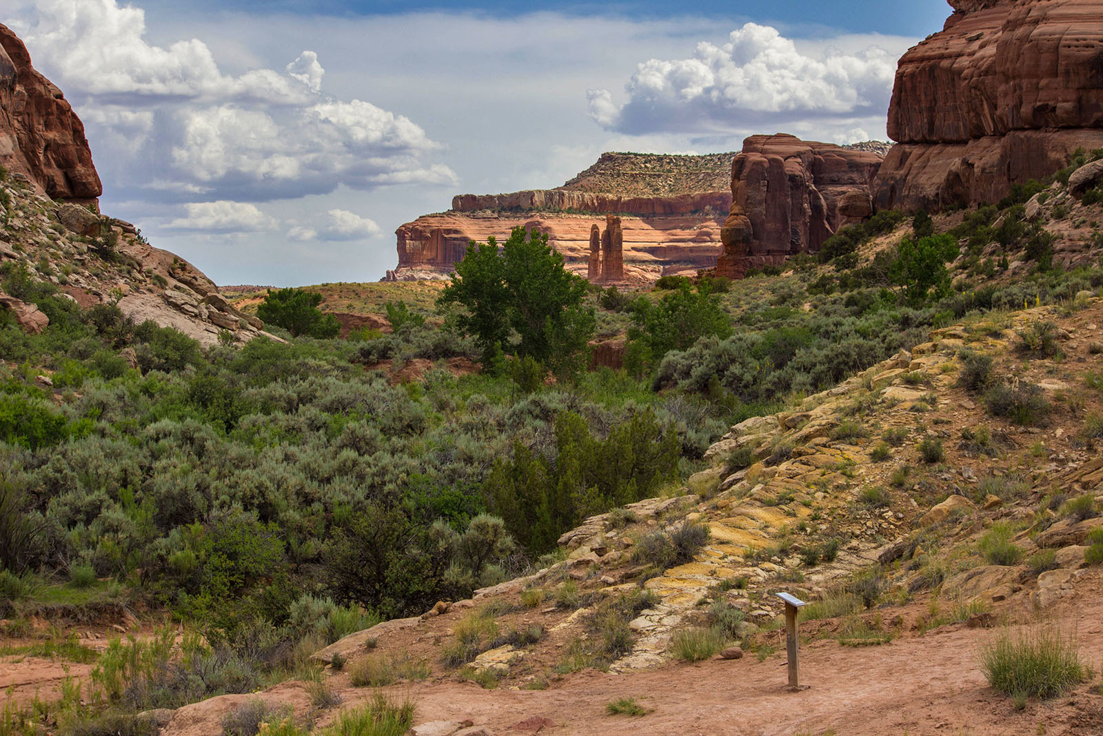
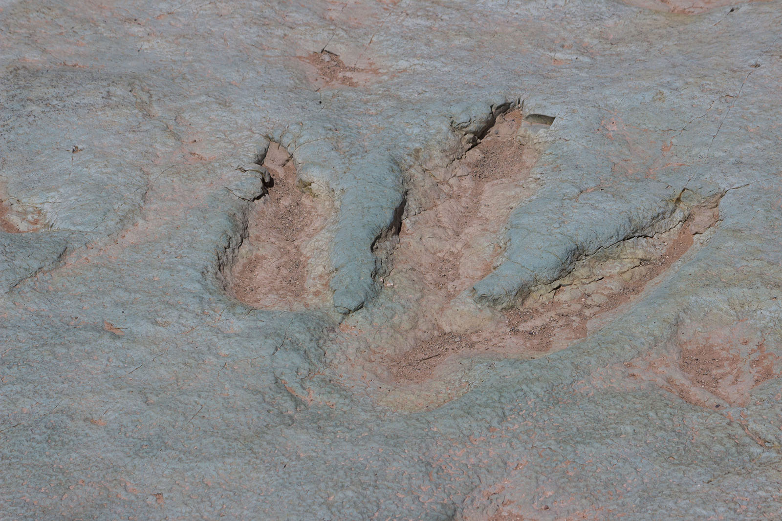
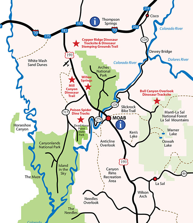
After learning about the dinosaur species that once walked these lands, continue north of Moab to one or more of the Moab Dinosaur Sites described on this page. A variety of hiking trails will take you to some of the best preserved dinosaur tracks and bones in the country.
Utah Friends of Paleontology
Moab Dino Coloring Book
Preservation
Localities like these are rare and need to be preserved for generations to come. Please be cautious and considerate when observing these dinosaur bones and tracks. Do not walk on the actual fossils. Collecting vertebrate fossils from Public Lands is illegal and violators will be prosecuted. Any disturbing, casting, rubbing or pouring anything into the fossils, including tracks, is expressly forbidden under federal regulations [43 CFR 8365.1-59a0 910].
Help the BLM preserve these paleontological resources for future generations by treating them with respect and reporting looting or vandalism to a Bureau of Land Management ranger or other local authority.
Contacts:
BLM Utah – Moab Field Office
82 East Dogwood
Moab, UT 84532
(435) 259-2100
US Forest Service – Moab Field Office
755 N Main St
Moab, UT 84532
(435) 259-7155
Join a BLM paleontologist and explore the world of dinosaurs. The Bureau of Land Management (BLM) Moab Field Office is launching its summer series of “Jurassic Walks and Talks.” Every weekend through Labor Day, a BLM paleontologist will lead free tours of dinosaur fossil and tracksites in the Moab area. On Friday, Saturday, and Sunday evenings, join the Moab BLM at the Moab Information Center in downtown Moab, for hands on activities for kids and talks by a dinosaur expert. These events are all free and everyone is invited. Maps and schedules are available at the MIC, which is located at 25 East Center Street. You can also download the current schedule at go.usa.gov/xNdsY.
With so many dinosaur resources in one place, Moab is the perfect place to design your own Family Dinosaur Field Trip!y
Start your Dinosaur Field Trip in downtown Moab, at the Museum of Moab. Check out a full cast skeleton of Gastonia, one of the armored dinosaurs that lived in this area during the Early Cretaceous. The museum also features numerous dinosaur displays, including a cast of the leg of the terrifying Utahraptor.
Continue your journey at Paleosafari Moab Giants, where you can journey back through time with a 3D cinema introducing you to the prehistoric world of dinosaurs. You can also make your own tracks on a half mile hiking trail populated with state-of the art life-size dinosaurs! The Tracks Museum features interactive learning touch screens, games to play, and visually stunning exhibits that not only fascinate, but educate.
After learning about the dinosaur species that once walked these lands, continue north of Moab to one or more of the Moab Dinosaur Sites described on this page. A variety of hiking trails will take you to some of the best preserved dinosaur tracks and bones in the country.
Utah Friends of Paleontology
Moab Dino Coloring Book
Preservation
Localities like these are rare and need to be preserved for generations to come. Please be cautious and considerate when observing these dinosaur bones and tracks. Do not walk on the actual fossils. Collecting vertebrate fossils from Public Lands is illegal and violators will be prosecuted. Any disturbing, casting, rubbing or pouring anything into the fossils, including tracks, is expressly forbidden under federal regulations [43 CFR 8365.1-59a0 910].
Help the BLM preserve these paleontological resources for future generations by treating them with respect and reporting looting or vandalism to a Bureau of Land Management ranger or other local authority.
Contacts:
BLM Utah – Moab Field Office
82 East Dogwood
Moab, UT 84532
(435) 259-2100
US Forest Service – Moab Field Office
755 N Main St
Moab, UT 84532
(435) 259-7155
Drinking Water – This is a high desert environment. During the hot months bring one gallon per person, per day.
Food – Eating at intervals provides an opportunity to rest and also provides the energy needed to complete the trail.
Good Footwear – Lightweight hikers or running shoes with rubbery soles are adequate for most hikes
Sun Protection – Sun hat, sunscreen, and sunglasses
Day Pack
Route Map or Trail Guide
First-Aid Kit
Insect Repellent
Cool Season Hikes – Long Pants, Sweater or Coat, Gloves, Hat
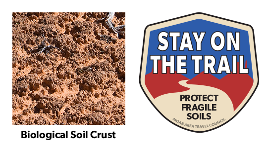
Help to keep all of our trails open. Protect this fragile, but crucial, soil by remaining on designated roads, routes and trails at all times.
Biological soil crust, also known as cryptobiotic soil, is the foundation of desert plant life. This black, knobby crust is made up of many different living organisms and plays a vital role in maintaining the desert ecosystem. However, this sensitive soil is extremely fragile and can take decades to grow. Even a footstep can damage the crust for decades, having lasting impacts on the desert environment. Please stay on the trials. Help to protect this fragile life by remaining on designated roads, routes, and trails at all times. Where hiking trails are not established, hike in sandy washes or on bare rock.
Intersection of Highways 191 and 313,
11 miles north of downtown Moab.
GPS: 38.671768, -109.686812
( 435) 355-0288
www.moabgiants.com
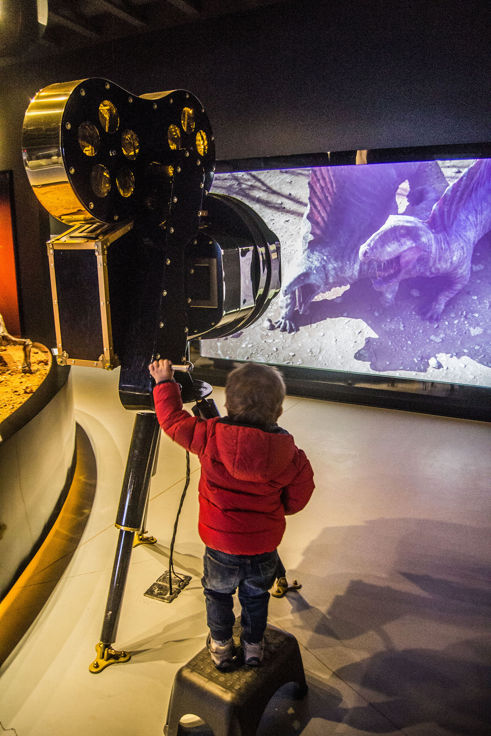
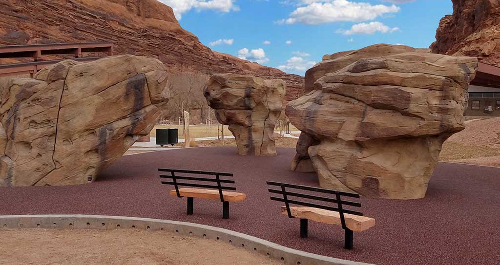
Moab Giants Dinosaur Park is the first of its kind world-wide! Not only is it set among some of the world’s most breathtaking scenery in Moab, it is also a unique experience of the ages. You will journey back through time with a 3D cinema introducing you into the prehistoric world. There you get to make your own tracks alongside state-of the art life-size dinosaurs! You get to roam the extraordinary landscape they called home, as evidenced by the huge concentration of fossilized tracks found all around the area. The Tracks Museum is full of entertainment with interactive learning touch screens, games to play, and visually stunning exhibits that not only fascinate, but educate. It’s the ultimate place to discover the past with the modern conveniences and cutting edge technology that feel like the future.
The perfect balance of adventure and science, Moab Giants has been the realization of a dream for both our dinosaur park enthusiasts, as well as our world renowned scientists. They have special expertise in the field of fossil footprints and a deep knowledge of the paleontology of the region. Moab Giants has been actively engaged for many years in research, public education and exhibits and they are dedicated to being an educational and scientific resource for visitors from the local community, region, nation and the world, but not without some extreme fun along the way! It is Moab Giant’s mission to explore the beauty, adventure and scientific mysteries of the Moab area and share them with the world.”
Plan to experience Moab Giants in its entirety by visiting all the attractions we have to offer. There is something for everyone to enjoy. Our exhibits include both indoor and outdoor experiences. Explore the park on your own and at your own pace, or participate in a more in-depth guided tour. Either way you will want to be sure you don’t miss a thing.
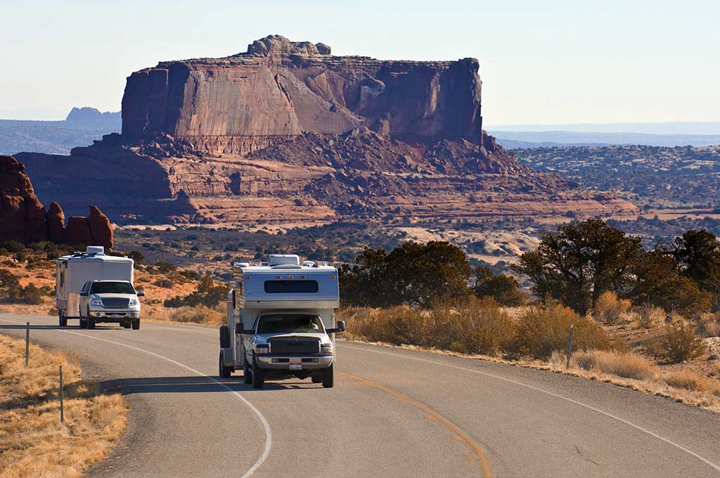
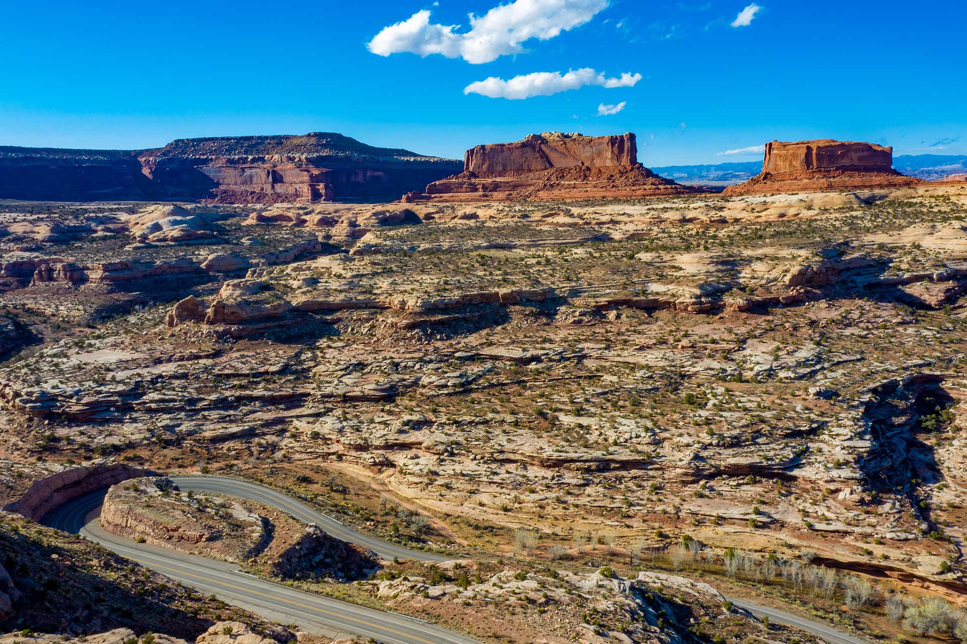
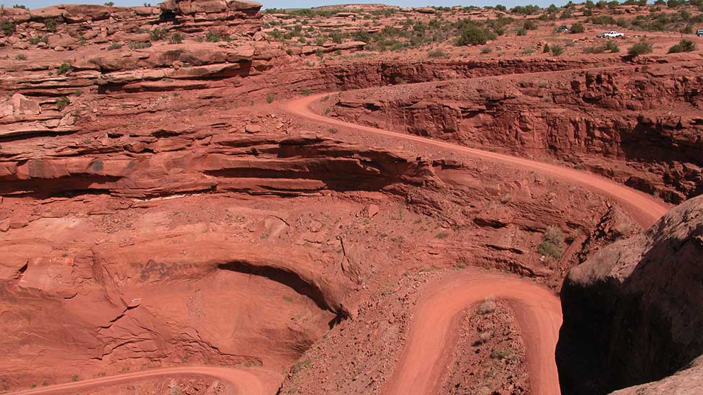
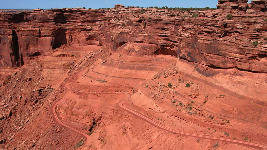
Scenic Byway U-313
Dead Horse Mesa Scenic Byway
U-313 is a 22.5 mile (36.2 km) long State highway that winds its way through Grand and San Juan Counties. The highway is the access road for Canyonlands National Park and Dead Horse Point State Park. U-313 was first built in 1975 in place of U-278.
Construction crew severely damaged the U-313 while constructing the road into what is now Canyonlands National Park. In 1988 the route was rebuilt from its original state of steep grades and blind switchbacks to its current state. The reconstruction of SR-313 was done at the same time as the access road into Canyonlands National Park.
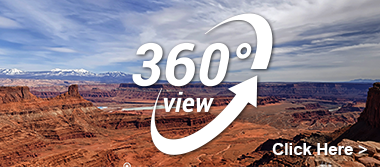
U-313 is currently called the Dead Horse Mesa Scenic Byway. This Scenic byway leads you to one of the most photographed landscapes in the world. Dead Horse Point makes you feel as if you are on top of the world, with some of the most amazing 360-degree views.
At the highest viewpoint on a clear day, the La Sal Mountains can be viewed to the east, the Abajo Mountains to the South, The Henry Mountains to the west and the Bookcliffs to the north.
The intersection of SR-313 and Hwy 191: mile marker 136.8 on US 191 and 11 miles (17.7 km) north of downtown Moab, Utah, 20 miles – 32.2 km (south of Exit 180 on I-70. This is the beginning of your journey to what seems to be the ends of the earth.
Before starting your journey you may want to travel .3 miles (.5 km) north on Highway 191 to fill your tank at the gas station located there. This station was one of the iconic movie locations in the 1997 movie Breakdown, starring Kurt Russell and Kathleen Quinlan. The plot is basically about a man searching for his missing wife after his car breaks down in the middle of the desert.
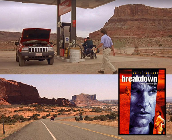
Kurt Russell gasses up his vehicle near the intersection of US-191 & U-313 in Breakdown.
Note: Don’t worry folks, reliable car service is just a phone call away in Moab.
Proceed back to the beginning of U-313 and set your trip odometer to 0.
This attraction has life size dinosaurs that walk the ground that they used to call home. https://moabgiants.com/
Moab Giants Dinosaur Park is the first of its kind world-wide. The perfect balance of adventure and science, Moab Giants has been the realization of a dream for both dinosaur park enthusiasts, and world renowned scientists. They have special expertise in the field of fossil footprints and a deep knowledge of the paleontology of the region.
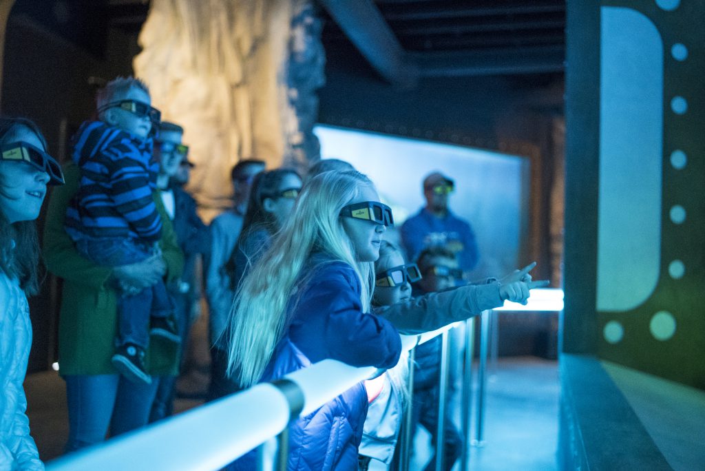
Not only is the park set among some of the world’s most breathtaking scenery, it is also a unique experience for all ages. Start your journey through time with a 3D cinema introducing you into the prehistoric world, and then venture outside and make your own tracks alongside over 100 state-of the art life-size dinosaurs. You will be roaming the extraordinary landscape dinosaurs once called home, as evidenced by the huge concentration of fossilized tracks found all around the area. The Tracks Museum is full of entertainment with interactive learning touch screens, games to play, and visually stunning exhibits that not only fascinate, but educate. The 5D Paleo-Aquarium gives you a realistic view into ancient life under the sea. Your time in the aquarium will end in the 5D room with an earth shattering experience you are sure not to forget!
Note: The Giant’s Cafe serves up a great selection of food items, and entrance into the park is not required. Stop in for lunch before starting your journey.
This roadside parking area contains information about Canyonlands National Park and Dead Horse Point State Park, along with information on travel and camping rules for the area. In addition to great views of the area’s geology, abandoned uranium mining activity is visible to the north on the cliffside.
On the left is a parking area through a gate. This canyon is closed to vehicle traffic about 2.2 miles (3.5 km) up but is open to horseback riders and hikers. Follow the wash up the main canyon. Along the main canyon walls, you may catch a glimpse of a few petroglyphs (these are tricky to find so keep an eye out). The canyon ends at a grotto that usually has water in a small pond (this is not for human consumption). 7.2 miles (11.6 km) round trip.
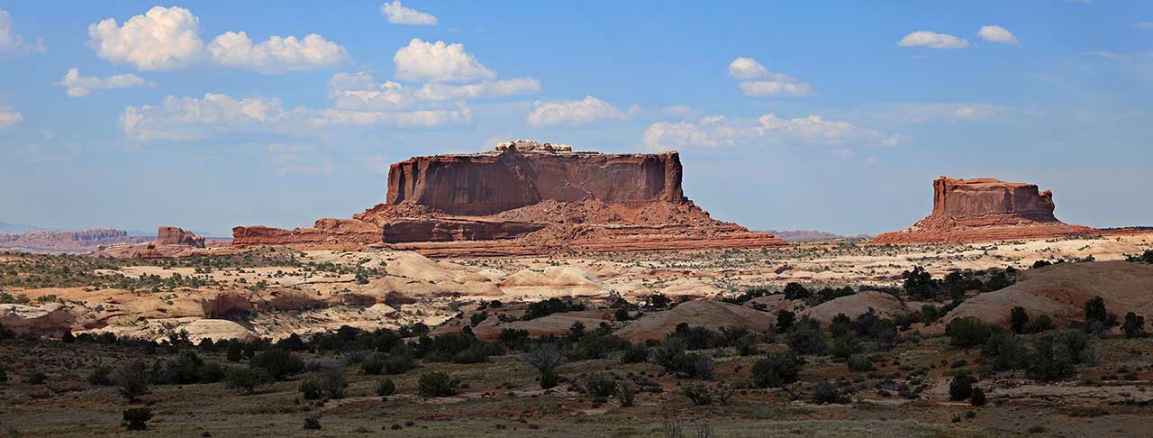
These two buttes were named for their resemblance to the Monitor and The Merrimack, two American Civil War steamships. Although Merrimac, the larger of the two buttes, looks large it is actually very thin at 200-600 feet wide and 1,600 feet long.
This parking area will give you access to a network of Mountain Biking trails. Navajo Rocks Chaco loop you can also access 7 up, Mag 7, and many other trails.
Views of the surrounding cliffs, along with the Monitor and Merrimac Buttes. This viewpoint is great for wildflowers in the spring.
This parking area is a great place to get some mountain biking, hiking and even four wheeling in. This parking area will give you access to some scenic easy four wheeling. This trailhead can take you up to a dramatic outcropping called determination towers. This is about an 8.8 mile up and back easy going scenic safari ride.
You can also access Monitor and Merrimac, Seven Mile Rim Safari Trail. Wipeout Hill Safari Trail.
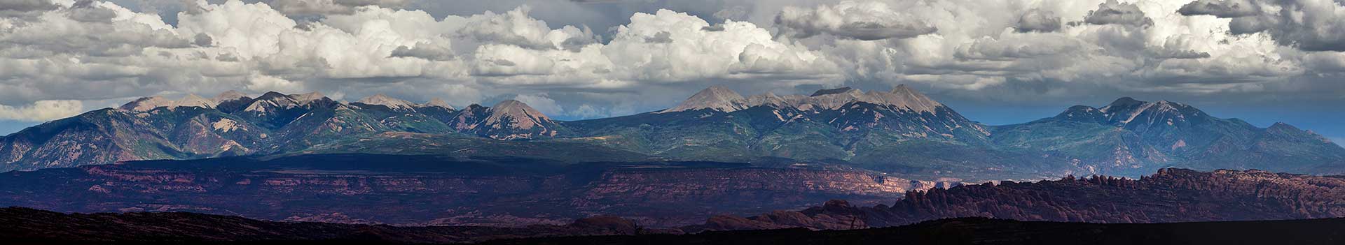
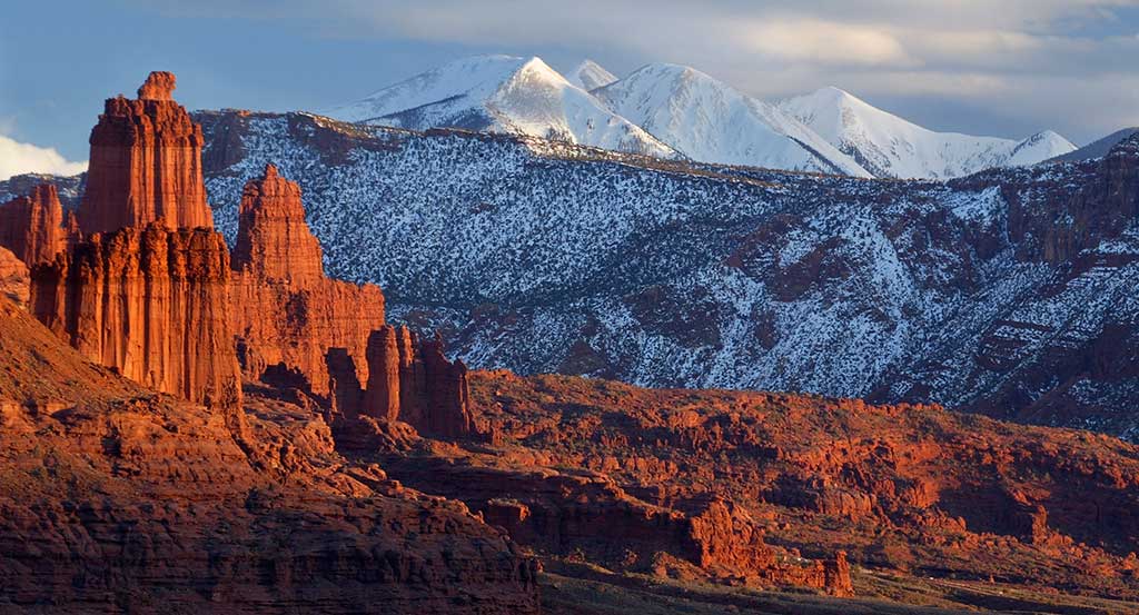
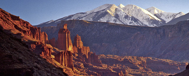
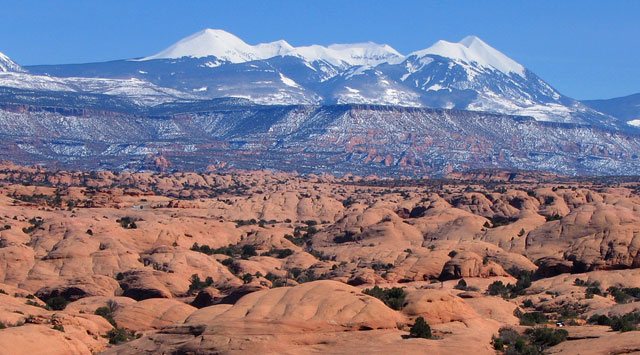
The roadside viewpoint has great views of the La Sal Mountains and the surrounding plateau country. The La Sal Mountains are part of the Manti-La Sal National Forest and the southern Rocky Mountains. The maximum elevation is at Mount Peale, reaching 12,721 feet (3,877 m) above sea level. The range contains three clusters of peaks separated by passes. The peaks span a distance of about 10 miles (16 km). The name of the range dates to Spanish times, when the Sierra La Sal (meaning the "Salt Mountains") were a prominent landmark on the Old Spanish Trail between Santa Fe and Los Angeles.
Continuing down Dubinky Well Road leads to many four-wheel drive roads that lead to canyons and vistas including:
Turn right on an unimproved dirt road and continue to a parking lot in 1.3 miles (2.1 km). A high clearance vehicle may be required based on conditions. This trail offers spectacular views across Hell Roaring Canyon to a large natural arch. From the parking lot, the trail passes through a fence and follows a dirt road for about 0.1 miles (.16 km). The trail leaves the road and goes down several dry washes until it rejoins an old road (closed to vehicles). After a short distance, the trail leaves the old road, and follows a series of rock cairns near the edge of Hell Roaring Canyon (400 feet deep).
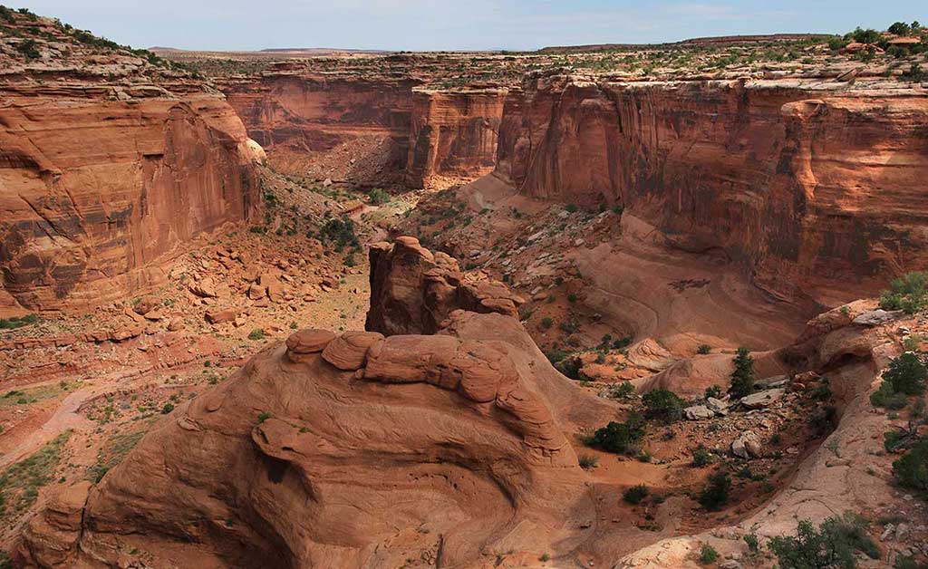
View of Hell Roaring Canyon on the trail to Jewel Tibbetts Arch
After a short distance, the trail follows a short spur onto a slickrock platform, from which spectacular views of the arch and the canyon below can be had. The trail returns to the parking lot across a blackbrush mesa, where it rejoins the road. The arch is named after Jewel Tibbetts, a Moab resident who lived about 10 miles’ (16.1 km) distance at the Horsethief Ranch in the 1950 and 1960’s with her husband Bill. They often took ranch visitors to see the arch. Note: Hikers should exercise caution on those sections of the trail which are close to the edge of Hell-Roaring Canyon. The trail can be very warm in summer. Neither mountain bikes nor motorized vehicles are allowed on this trail, except for the first 0.1 miles (.16 km) where the trail follows an existing road. Length of Hike: 2.1 miles (3.4 km), round-trip (semi-loop); allow about 2 hours round-trip.
Campsites are tucked in the pygmy pinyon-juniper forest on the mesas above Moab, yet offer great views. Individual sites are available on a first-come, first-served basis. One group site, Horsethief Group Site, is available for reservation through Recreation.gov. This campground is close to Canyonlands National Park and Dead Horse Point State Park.
The road is well maintained and is rated as easy. It is about 13 miles (20.9 km) to the switchbacks that lead you down to the White Rim Trail and the Green River. The steep switchbacks are scenic and easy as you descend about 500′ to the bottom. Although the road is suitable for high-clearance two-wheel-drive vehicles when dry, the unpaved sections of the road can be impassable when wet. In any case, driving 4WD is recommended due to uneven surface. Once on the bottom, turning right will lead you to a dead end at Mineral Bottom, where rafting boats are launched. If you turn left you are on the White Rim Trail in Canyonlands National Park. (A permit is required for the White Rim: https://www.nps.gov/cany/planyourvisit/dayusepermits.htm)
Gemini Bridges is one of the most popular spots in Moab. The Gemini Bridges Trail is well known to local mountain bike riders for its scenery and long descents. Starting from U-313, the trail is nearly all downhill back to US-191. Approximately 5.5 miles from U-313, the spur route to Gemini Bridges is encountered. This route is a hiking route only and is a short 0.2 mile walk. After viewing the bridges, enjoy the rest of the marked trail down to Highway 191. This bike route utilizes a county road and is shared with jeeps, ATV/UTVs, and dirt bikes.
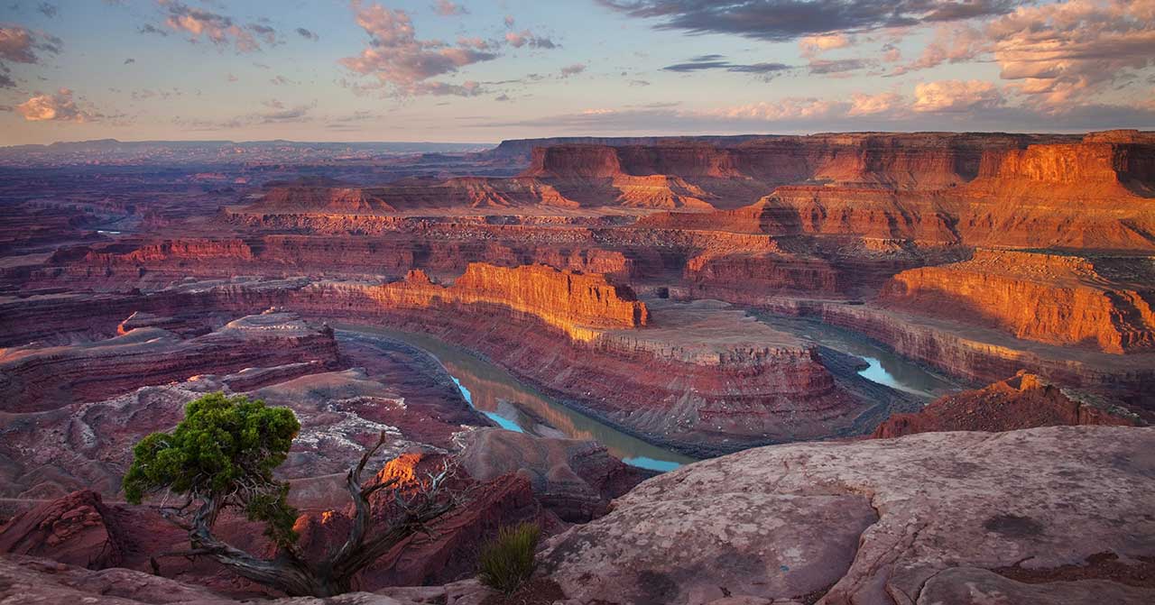
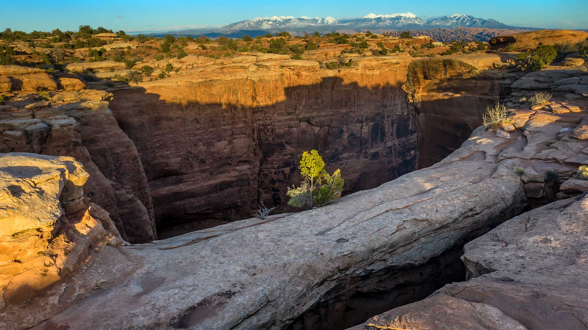
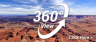
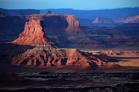
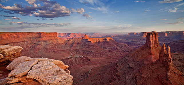
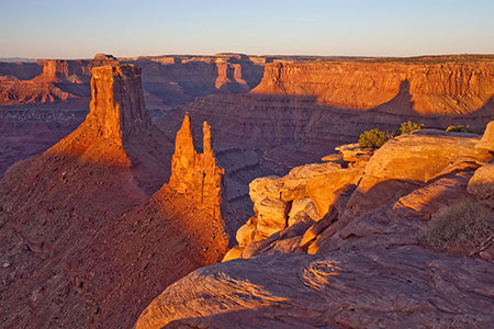
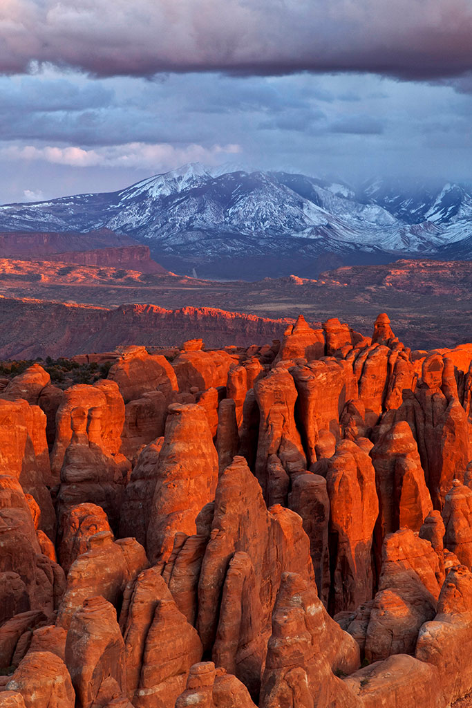
From the prominence of Dead Horse Point, 2,000 feet above a gooseneck in the Colorado River, an ever-changing landscape unfurls. Immense vertical cliffs meet with canyons carved by ice, water, and wind creating a visual masterpiece.
Millions of years of geologic activity created the spectacular views from Dead Horse Point State Park. Deposition of sediments by ancient oceans, freshwater lakes, streams and wind blown sand dunes created the rock layers of canyon country. Igneous activity formed the high mountains that rise like cool blue islands out of the hot, dry desert.
An entrance fee is required.
A perfect location for experiencing sunrise, sunset and a bit of seclusion, the Moenkopi Yurts offer a glorious camping experience up at Dead Horse Point State Park. With sweeping views and a private spur to the Intrepid Trail System this yurt site can be your quiet spot of heaven while enjoying the Moab area. These Yurts can be reserved at https://www.reserveamerica.com/explore/dead-horse-point-state-park/UT/344161/overview
A gift shop is located inside the visitor center and offers park visitors a variety of quality souvenirs including shirts, hats, postcards, cups, handmade knives, magnets, art work, pottery, snacks, etc.
On the road, about a quarter of a mile from the lookout point, you’ll pass the bottleneck which is only about 30 feet wide. Here, once the horses would be herded in, a fence and gate were placed trapping the horses. The cowboys could then pick out the wild horses they wished to keep. Unfortunately, as the story goes, once the cowboys picked the horses they wanted, they opened the gate at the bottleneck and left. It was said that the wild horses were so spooked that many didn’t leave the point, even though the gate was open, and being on top of a mesa, with no shade and no water, they died of thirst.
This is the main attraction of Dead Horse Point State Park. From the overlook parking lot, a short paved pathway leads to breathtaking views of the Colorado River and adjacent canyon country some 2,000 feet below. A large shelter at the overlook provides relief from both foul weather and summer heat. Paved pathways lead out in both directions from the shelter, providing additional viewpoints while linking up with both the East and West Rim trail systems.
Although the primary overlook and shade shelter are accessible, the eastern and western spur trails contain steeper inclines and short sections of slick rock interspersed with the pavement.
Scenic Byway U-128
Every twist and turn holds something new.
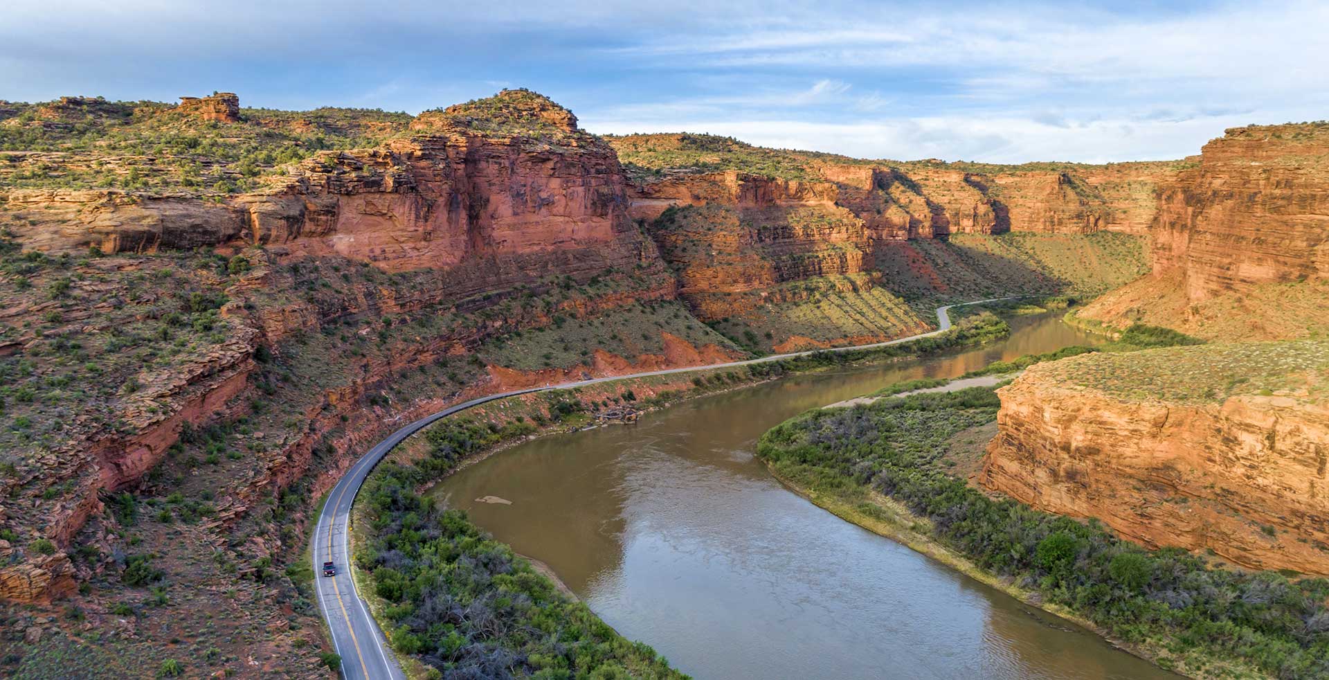
This spectacular route along the Colorado River gorge begins at the Colorado River Bridge on the north end of Moab. Spending a day exploring this section of the river gorge will provide you with jaw dropping scenery and take you to the sixth-longest natural rock span in the United States, world famous movie locations, beautiful picnic and bouldering areas, a Film Heritage Museum, a large variety of hiking trails including one that goes to the breathtaking Fisher Towers, historical points of interest, guided horseback riding opportunities, outdoor dining, a brand new mercantile (opening in 2020) and a ghost town.
Utah State Route 128 (U-128) is a 44.6-mile-long (71.7 km) state highway north of Moab. The entire length of the highway has been designated the Upper Colorado River Scenic Byway, as part of the Utah Scenic Byways program. This road also forms part of the Dinosaur Diamond Prehistoric Highway, a National Scenic Byway. Residents of Moab frequently refer to SR-128 as “the river road”, after the Colorado River, which the highway follows.
The highway was originally constructed to connect rural cities in eastern Utah with Grand Junction, Colorado, the largest city in the region. Part of the highway was merged into the Utah state highway system in 1931; the rest was taken over by the state and assigned route number 128 in 1933. Today, the highway is used as a scenic drive for visitors to the area.
The highway crosses the Colorado River at the site of the Dewey Bridge, listed on the National Register of Historic Places. This bridge was the longest suspension bridge in Utah until April 2008 when it was destroyed by a fire.
To begin this tour, set your odometer to 0 at the intersection of US-191 and U-128.
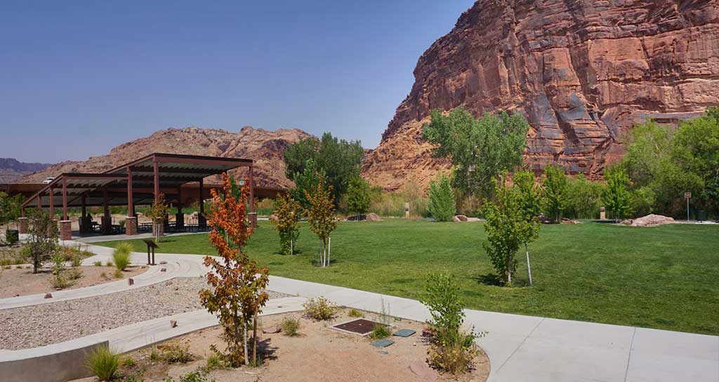
This scenic park is located on the banks of the Colorado River just north of Moab on U-128 at the intersection with US 191. It’s a lovely facility with a paved parking area and big shade trees along the riverbank. There’s a footbridge over the Colorado River that connects paved trails that go north-south along US 191 and east-west along U-128 and the river through red rock canyons. Restrooms and picnic areas are available. Facilities are wheelchair-accessible.
Lions Park also contains Moab Boulder Park. Moab is a very, very difficult place to get going when you’re a beginner at climbing, and this park really bridges the gap from beginners to help them get out on the cliffs. Along with three custom-made boulders that were color-matched to blend with Moab’s surrounding red rocks, the park also includes a thick rubber surface beneath the climbing rocks to help cushion the inevitable falls.
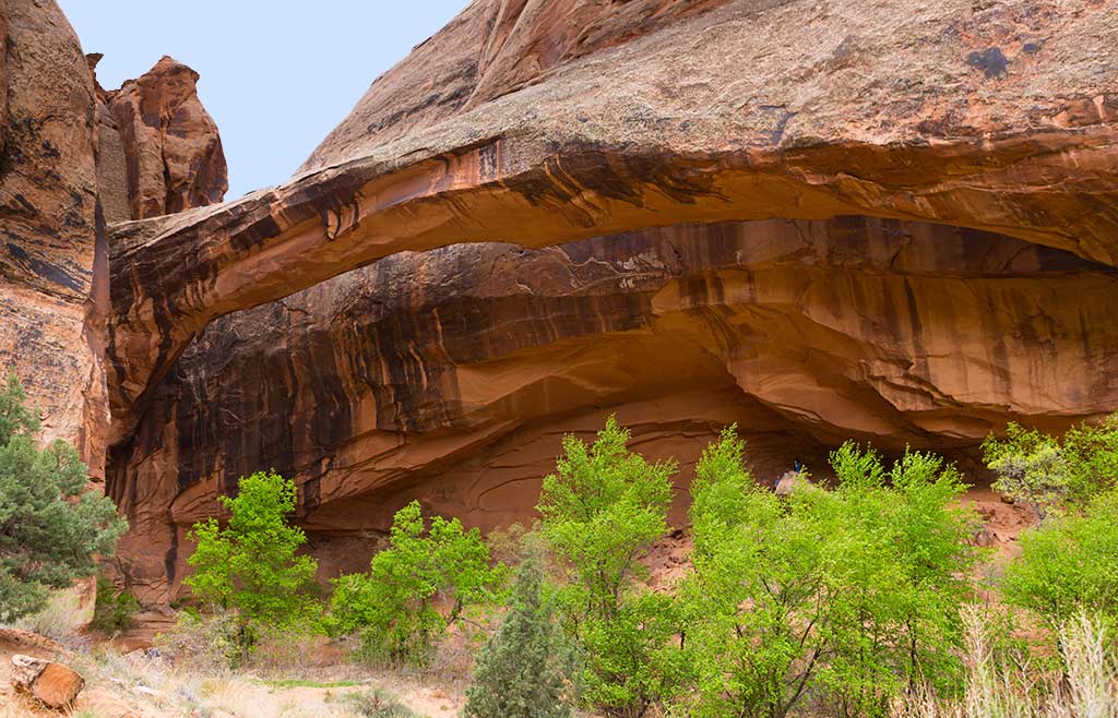
Continuing down U-128, the drive parallels the Colorado River within a narrow section of the Colorado River gorge, providing breathtaking views of the surrounding red sandstone cliffs. Popular attractions along this portion of the route include viewpoints of the river, public camping areas, and Grandstaff Canyon, which contains a delightful hiking trail to Morning Glory Natural Bridge.
Grandstaff Canyon was named after William Grandstaff, an African American prospector and rancher who grazed his cattle here during the late 1800s. It is a lovely canyon, cut into the Navajo Sandstone by a small, perennial stream that begins about six miles from the southern shore of the Colorado River. The trail winds along the stream through an oasis of cottonwood and willow trees, cut off from the desert above by towering sandstone cliffs. Like all good hikes, this one also has a reward at the end. Morning Glory Natural Bridge spans the head of one of Grandstaff’s side canyons at the end of the trail. According to Bureau of Land Management statistics, Morning Glory is the sixth largest natural bridge in the United States.
Grandstaff Canyon was named after William Grandstaff, an African American prospector and rancher who grazed his cattle here during the late 1800s. It is a lovely canyon, cut into the Navajo Sandstone by a small, perennial stream that begins about six miles from the southern shore of the Colorado River. The trail winds along the stream through an oasis of cottonwood and willow trees, cut off from the desert above by towering sandstone cliffs. Like all good hikes, this one also has a reward at the end. Morning Glory Natural Bridge spans the head of one of Grandstaff’s side canyons at the end of the trail. According to Bureau of Land Management statistics, Morning Glory is the sixth largest natural bridge in the United States.
Big Bend Bouldering Area has something for every age and ability. Located right off the highway, literally across the street from the Colorado River, it is hard to find a more scenic location for bouldering. It’s not unusual to have beginners working next to world-class climbers. Bring a comfortable chair and watch the show or work the routes yourself.
At 13 miles (20.9 km) the gorge widens as the highway proceeds past Castle and Professor Valleys, which have been the shooting locations for many western films including Wagon Master and Rio Grande, along with numerous television commercials.
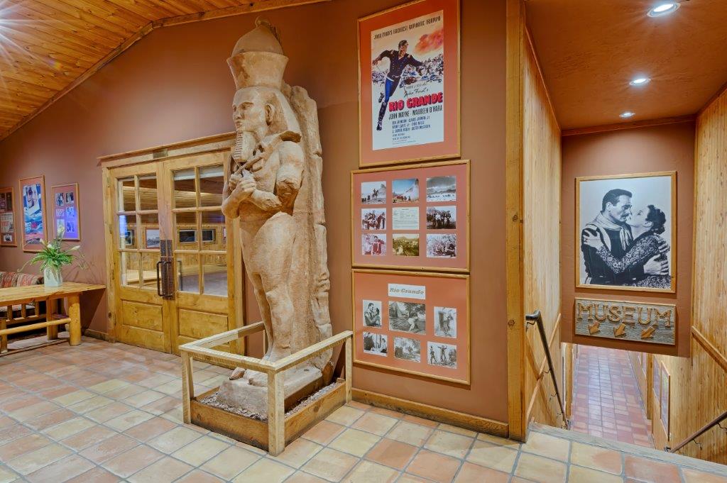
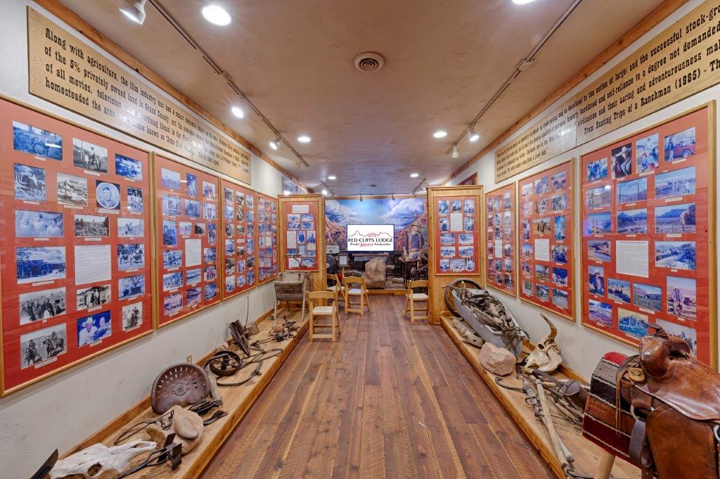
Red Cliffs Lodge, on the banks of the mighty Colorado River, is home for the Moab Museum of Film & Western Heritage. The lodge is built on the old George White Ranch, a key location for nine of the big Westerns including Rio Grande, Cheyenne Autumn, Ten Who Dared, The Comancheros, and Rio Conchas. The late George White was founder of the Moab to Monument Valley Film Commission, the longest ongoing film commission in the world. In the museum one can learn more about film locations, how the sets are built, and how the filming process is managed on nature’s own sound stage. On display in the museum are production photographs, movie posters, autographed scripts, props from the many pictures filmed in the area, and displays about the western ranching heritage.
Dozens of movies have used the ranch and surrounding area as the set and backdrop for their films. From Disney to Spielberg and from westerns to sci-fi, Moab has been the scenic choice for some of Hollywood’s greatest movies. Red Cliffs has hosted some of its biggest stars; John Wayne, Maureen O’Hara, Rock Hudson, Henry Fonda, Roger Moore, Burt Reynolds, Jason Patrick, Johnny Depp and many, many more.
During the season, Red Cliffs Lodge offers an outdoor lunch on the banks of the Colorado River. (Open to the public as well as guests.)
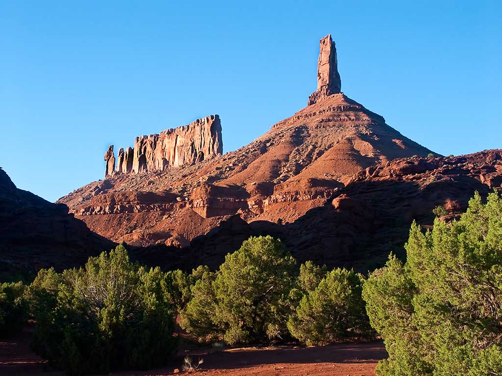
Castleton Tower is a 400-foot (120 m) Wingate Sandstone tower standing on a 1,000 foot Moenkopi-Chinle cone above the northeastern border of Castle Valley. The Tower is world-renowned as a subject for photography and for its classic rock climbing routes, the most famous of which is the Kor-Ingalls Route featured in the famous guidebook “Fifty Classic Climbs of North America”. In 1964, Chevrolet filmed a commercial for the Impala convertible perched atop the tower.
Adjacent to Castleton Tower is The Rectory, a thin 200 foot (61 m) wide, and 1,000 foot (305 m) long north-to-south butte with 200 ft vertical Wingate Sandstone walls tower standing on a 1,000 foot Moenkopi-Chinle base. The Jon Bon Jovi music video Blaze of Glory was filmed at The Rectory. The Australian band Heaven also filmed their Knockin’ on Heaven’s Door music video on top of The Rectory.
Note: There are great views of these formations from the Sylvester Trail (below).
Opening to the public in Spring 2020, on the property of Sorrel River Ranch, JJ’s Mercantile will provide everything from gifts, groceries and gear for the guests of the resort, campers, locals and those passing through. Stop by for hot coffee, tantalizing pastries, fresh baked bread, tasty sandwiches and salads artfully prepared from JJ’s open kitchen and ready to go.
From the Professor Valley Ranch Road turn-off on the right, drive 2.2 miles (3.5 km) on a well graded road to the trailhead.
The Sylvester Trail is in the Onion Creek area and follows open desert through the Professor Valley drainage and features beautiful views of the surrounding terrain. The trail is named after Dr. Sylvester Richardson, who with his wife Mary Jane, were among the first settlers in the valley back in the 1880’s. Sylvester’s nickname was ‘Professor’ for which the valley is named.
From the parking area, follow the trail which is relatively flat and easy. The trail will cross a dry wash several times before it begins to ascend a bench on the right. The trail weaves along this bench gradually ascending. The rock formations include the Preacher, The Nuns, Rectory and Castleton Tower. Once the trail passes the foot of Castleton Tower, it will begin to descend slightly.
When you reach a dirt 4×4 road, the Sylvester Trail ends and you return the way you came. 6.9 miles (11.1 km) round-trip. (The trail is shared with equestrian users and there is no shade, so avoid on hot days.)
Turn right on the well graded dirt road, then travel 2.2 miles (3.5 km) to the trailhead. The Fisher Towers trail is a world class experience. The views of Castle Rock and the shear sandstone cliffs of the Colorado River are stunning. This is an out and back hike will take you by 3 amazing formations, The Kingfisher, Echo Tower and The Titan. This area is popular with rock climbers so keep an eye up on the rocks. The trail descends into the canyons in several places which brings the overall elevation gain to about 1000 feet. The best picture taking time is probably when the afternoon sun is looking over your shoulder at the towers but alas that is also the most unforgiving time on a hot summer day so be sure to bring plenty of water.
Turn left into Hittle Bottom Parking Area – The trail starts across the street and features broad sweeping views and solitude. 2.8 mile loop.
This is a foray into the heart of the Richardson Amphitheater, near the Colorado River, in an area of beautiful rock formations. The Amphitheater Loop Trail is approximately 4 miles (6.4 km) from the Fisher Towers Trailhead and both trails can be walked in a single day. The Amphitheater Loop Trail makes a lovely walk, and climbs approximately 250 feet in elevation to afford a stunning view of the Colorado River corridor. Along the way, you can see interesting sandstone formations in the Moenkopi and Cutler sandstone layers.
The roadside viewpoint on the left provides one of the grandest views in the west, the red rock spires of the Fisher Towers set against the often snow covered peaks of the La Sal Mountains.
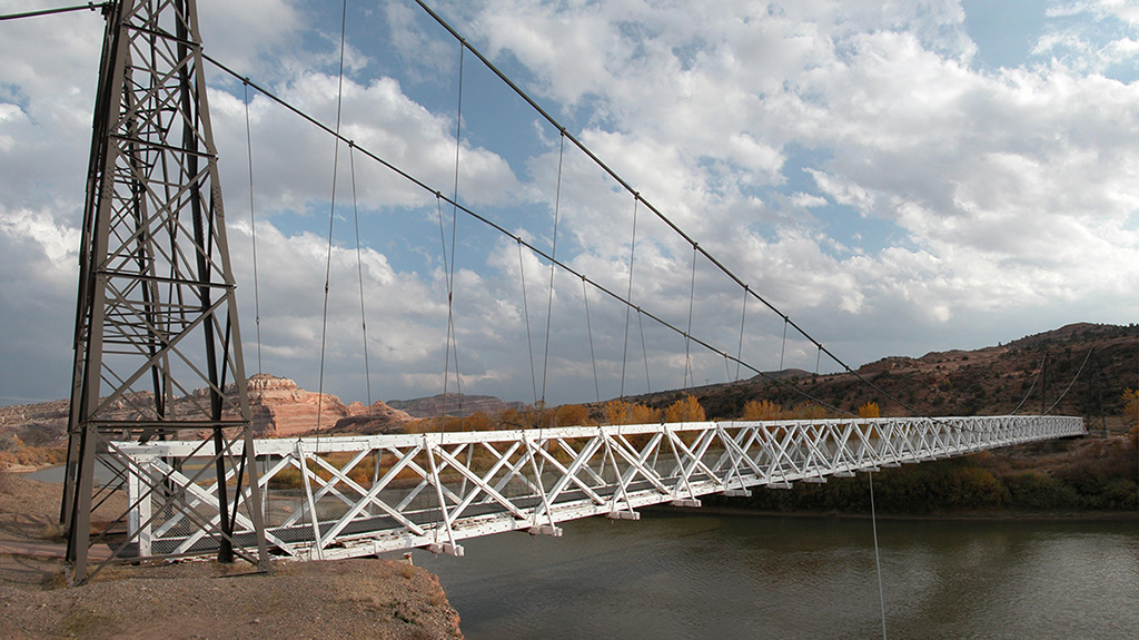
Historic Dewey Bridge, before it was destroyed by fire in 2008.
Dewey Bridge, built in 1916, originally carried U-128 across the Colorado River. The bridge featured an all wood deck measuring 502 feet (153 m) long, 10.2 feet (3.1 m) wide from support to support and 8 feet (2.4 m) wide from rail to rail. The bridge also consisted of two metal towers, a run of seven cables on each side of the bridge deck, and cable anchors. The bridge was designed to support the weight of six horses, three wagons, and 9,000 pounds (4,100 kg) of freight.
On the day of its completion, it was the second-longest suspension bridge west of the Mississippi River. The longest was the Cameron Suspension Bridge, also built by the Midland Bridge Company, who used the same base plans for both bridges. Dewey Bridge remained the longest suspension bridge in Utah until it was destroyed by fire in 2008. The remains of the bridge and a historical marker remain on the site.
The town started in the 1880s as a saloon and water-refilling station for the Denver and Rio Grande Western Railroad. As work crews and, later, travelers came through, stores, hotels and restaurants sprang up to accommodate them. Nearby cattle ranchers and sheepherders in the Book Cliffs north of town began using Cisco as a livestock and provisioning center. Around the turn of the 20th century, over 100,000 sheep were sheared at Cisco before being shipped to market. After oil and natural gas were discovered, people began traveling more and Cisco continued to grow. The town’s decline coincided with the demise of the steam locomotive. A declining economy crashed when Interstate 70 was built, bypassing Cisco. After another 5 miles (8 km) the route intersects Interstate 70.
Memorial Day Weekend
Tips for an enjoyable visit.
Visitors can expect long lines at park entrance gates during Memorial Day weekend.
Arches and Canyonlands national parks are preparing for a busy Memorial Day weekend, and are advising visitors to expect heavy traffic, crowded trails, and limited parking.
“Memorial Day weekend is typically our busiest weekend of the year,” said Superintendent Kate Cannon. “We recommend patience and flexibility for visitors planning a trip to the parks.”
Visitors arriving at the parks between 9:00 a.m. and 2:00 p.m. should expect long lines at park entrance gates that could last up to an hour. Parking lots and trails inside the parks will be very crowded. If the parks become full, staff may delay vehicles from entering the park until space opens to accommodate more people and vehicles.
“We want these entry delays to be as short as possible. To avoid being caught in a delay, we recommend people come to the parks early in the morning or late in the afternoon,” Cannon said.
Park rangers ask that vehicles waiting in line at the entrance gate keep pace with traffic in the line and have payment ready. Credit cards are preferred. Current pass holders and returning visitors should have passes and identification ready. There are no toilet facilities or drinking water along park entrance roads.
When the park is full, we may temporarily delay entry into the park. These delayed entries would likely occur late morning or early afternoon. We may need two or three hours until conditions ease before we resume normal operations. During the peak time of the day, consider visiting one of the many nearby attractions in the Moab area (see below).
Visitors should plan for their safety by packing water and snacks and wearing sturdy shoes and sun protection.
Visitors are encouraged to check the parks’ websites or Twitter accounts for current entrance gate information and road conditions prior to leaving for their visit.
Arches:
Canyonlands:
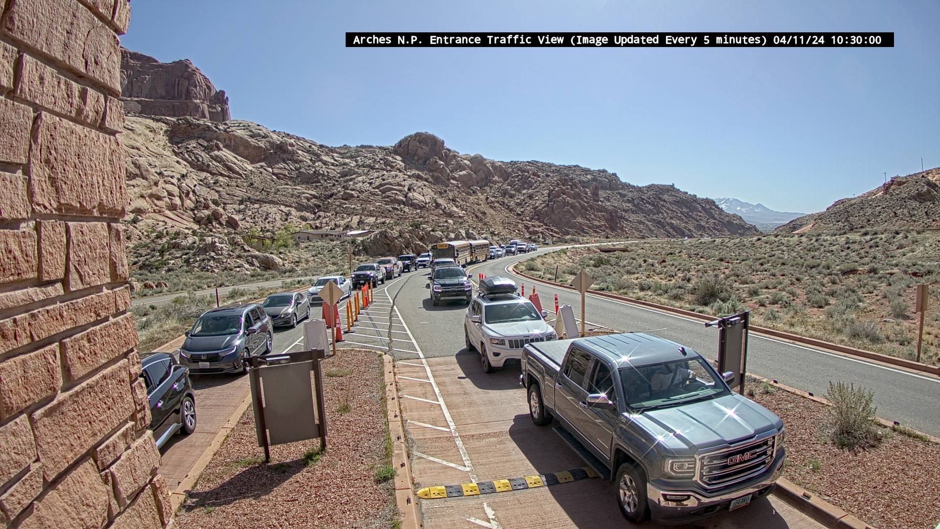
The webcams below provide views from either end of the Arches National Park entrance road. Traffic may back up between the entrance station and US 191 causing delays of up to an hour.
Arches National Park Entrance Road

Highway 191 near Arches National Park Entrance Road.
The Corona Arch trail leads to one of the most impressive arches in the entire Moab area.
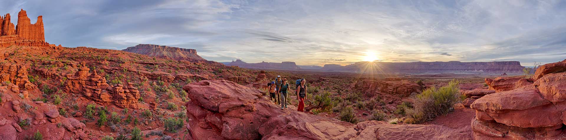
The Moab area contains a large number of pet friendly trails on public lands to suit any experience level. From cool stream-side hikes to spectacular sandstone arches, the Moab area is full of exciting day-hikes suitable for the entire family. What follows is just a taste of what Moab has to offer.
Dinosaurs contemplate mountain biking in Moab.
With so many dinosaur resources in one place, Moab is the perfect place to design your own Family Dinosaur Field Trip!
Start your Dinosaur Field Trip in downtown Moab, at the Museum of Moab. Check out a full cast skeleton of Gastonia one of the armored dinosaurs that lived in this area during the Early Cretaceous. The museum also features numerous dinosaur displays, including a cast of the leg of the terrifying Utahraptor.
Continue your journey at Paleosafari Moab Giants, where you can journey back through time with a 3D cinema introducing you to the prehistoric world of dinosaurs. You can also make your own tracks on a half mile hiking trail populated with state-of the art life-size dinosaurs! The Tracks Museum features interactive learning touch screens, games to play, and visually stunning exhibits that not only fascinate, but educate.
After learning about the dinosaur species that once walked these lands, continue north of Moab to one or more of the Moab Dinosaur Sites. A variety of hiking trails will take you to some of the best preserved dinosaur tracks and bones in the country.
Birthing Scene
The Moab area has numerous examples of Indian rock art to enjoy. This page briefly discusses some types, dates, the artists and their cultures and how to take care of these irreplaceable sites. Directions are included to a number of sites which allow you to sample some of the easily accessible ancient rock art in the Moab area. All sites are accessible with a passenger car and a short walk!
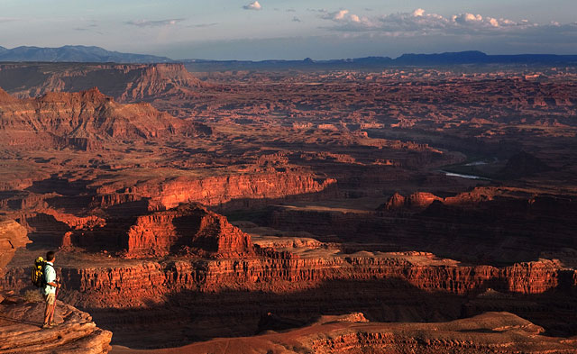
Dead Horse Point provides the same type of views you would experience in Canyonlands National Park.
32 miles (51.5 km) from Moab, Dead Horse Point State Park is one of Utah’s most spectacular state parks. The view from Dead Horse Point is one of the most photographed scenic vistas in the world. Towering 2,000 feet above the Colorado River, the overlook provides a breathtaking panorama of Canyonlands’ sculpted pinnacles and buttes. Millions of years of geologic activity created the spectacular views from Dead Horse Point State Park. Deposition of sediments by ancient oceans, freshwater lakes, streams and wind blown sand dunes created the rock layers of canyon country. Igneous activity formed the high mountains that rise like cool blue islands from the desert below.
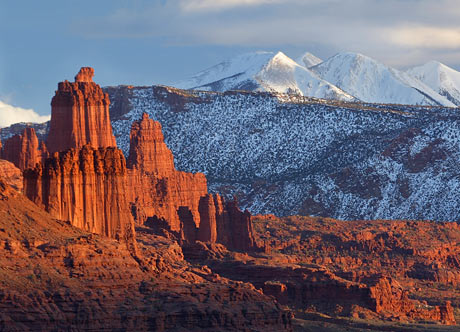
View of Fisher Towers from along Upper Colorado River Scenic Byway (U-128)
The Moab area is blessed with three State Scenic Byways. State Scenic Byways help recognize, preserve and enhance selected roads throughout the United States based on their archeological, cultural, historic, natural, recreational and scenic qualities. Every trip to Moab should include a drive along at least one byway, although driving all three is great way to spend a relaxing day.
Moab Brands Focus Area
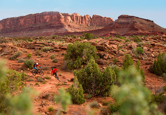
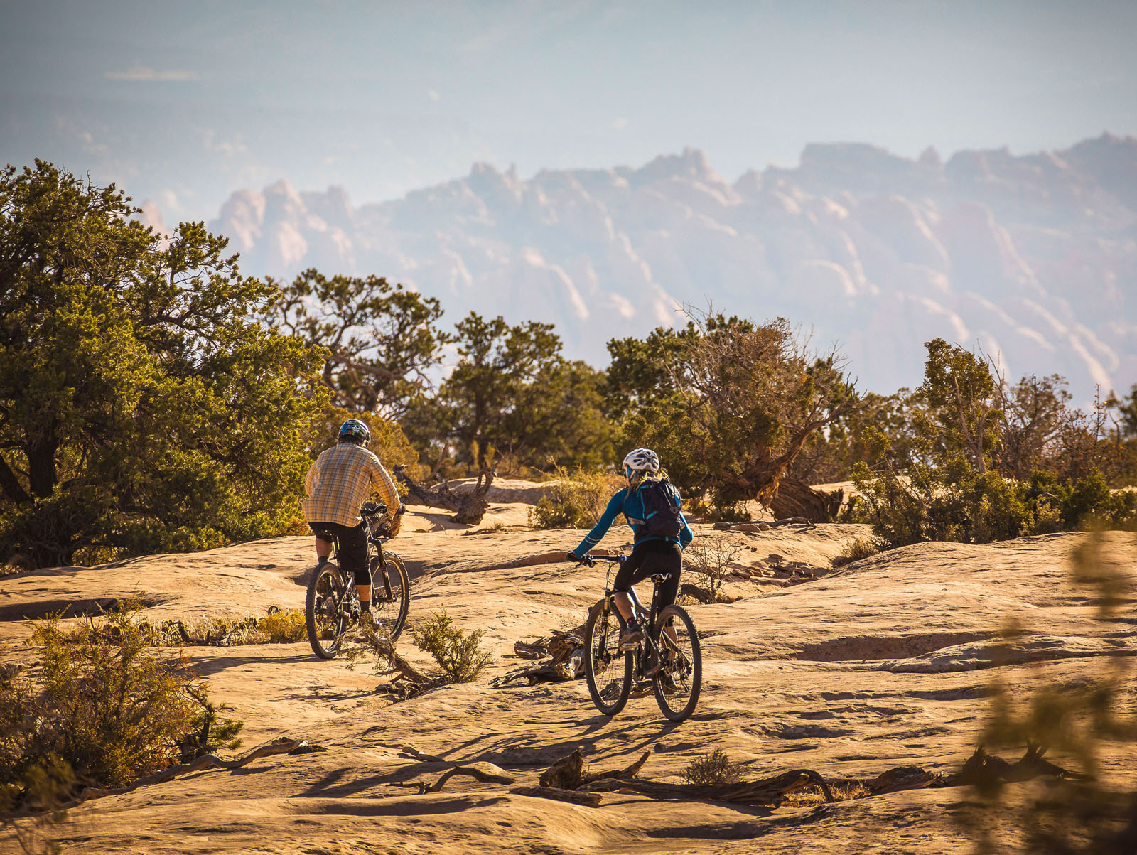
Welcome to the home of the greatest mountain biking on the planet! Moab offers a huge variety of trails for mountain bikers of any experience level, from beginners looking for a scenic ride through beautiful canyons and mesa tops, to seasoned bikers looking for the ultimate challenge. Moab is well known for the world famous, and highly technical, Slickrock Bike Trail. This challenging 9.6 mile trail is considered by many to be the ultimate mountain biking experience. Moab, however, also contains a huge assortment of scenic biking trails of all difficulty levels.
Sand Flats Recreation Area
The Sand Flats Recreation Area near Moab, Utah is a nationally significant public lands treasure at the heart of the Colorado Plateau. A high plain of slick rock domes, bowls and fins, it rises in the east to meet the colorful mesas and nearly 13,000 foot peaks of the La Sal Mountains. Sand Flats’ famous Slickrock and Porcupine Rim bike trails and almost 40 miles of jeep trails are world-renowned for their combination of challenge and awesome scenery. Sand Flats is also popular for camping. Over 100,000 visitors enjoy this 9,000-acre recreation area annually.
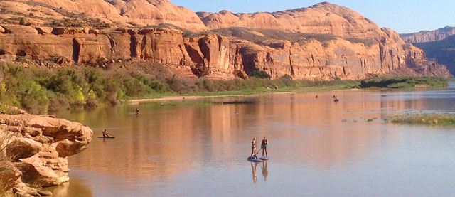
Paddle Boarding on the Colorado River
While our area is known for its family oriented whitewater trips on the Fisher Towers section of the Colorado River, there are wilder single and multi-day trips available in Westwater Canyon. Additionally, canoes, kayaks, and paddle boards are the perfect way to explore the calm water segments of the Colorado. Individuals or groups may raft the river on their own or with a professional river outfitter.
Arches National Park Webcams
Check on traffic before you go!
The webcams below provide views from either end of the Arches National Park entrance road.
Timed Entry Reservation System Update for 2024
Between November 1, 2023 and March 31, 2024, timed entry tickets will not be necessary to enter the park.
Between April 1, 2024 and October 31, 2024 Arches National Park is implementing a Pilot Timed Entry Reservation System. This system provides reliable access to the park and results in a higher quality visitor experience. Prior to this system there was no guarantee of access to the park during the peak season. With a little advanced planning visitors enjoyed a stress-free visit to one of the most beautiful national parks in the nation. Read more…
Arches National Park Entrance Station
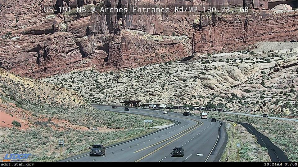
Highway 191 at Arches National Park Entrance Road.

Traffic heading into Moab at the intersection of Highway 191 and Highway 128.

Highway 191 near 500 West in Moab.
Visit our Arches National Park Trip Planner to learn more about visiting the park.
Arches National Park’s Twitter page is a great source of up-to-the-minute park information. Check it out here.
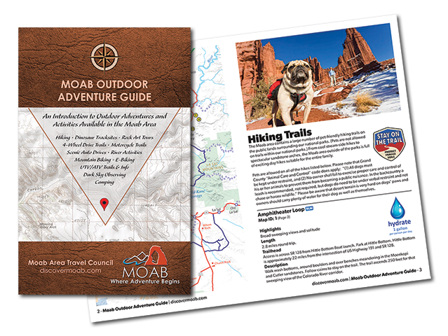
Don’t have a reservation? Introducing the Moab Outdoor Adventure Guide — a comprehensive resource showcasing the diverse range of adventures and activities awaiting you outside of the national parks. Whether you’re drawn to hiking, off-road driving, river activities, scenic byways, dark sky observing, mountain biking, e-biking, rock art tours, camping, dinosaur trails, or exploring with your furry companions, this guide is your ultimate companion.
The Moab Outdoor Adventure Guide is now available, free of charge, at the Moab Information Center located at the corner of Main and Center Streets in Moab. For your convenience, an ebook version is also available for download. To access the guide online and embark on your virtual exploration, simply Click here.
This comprehensive guide is designed to lead you on the right path, ensuring you make the most of your Moab adventure. Discover the countless possibilities and make memories that will last a lifetime. Get your copy of the Moab Outdoor Adventure Guide today and let the excitement begin!
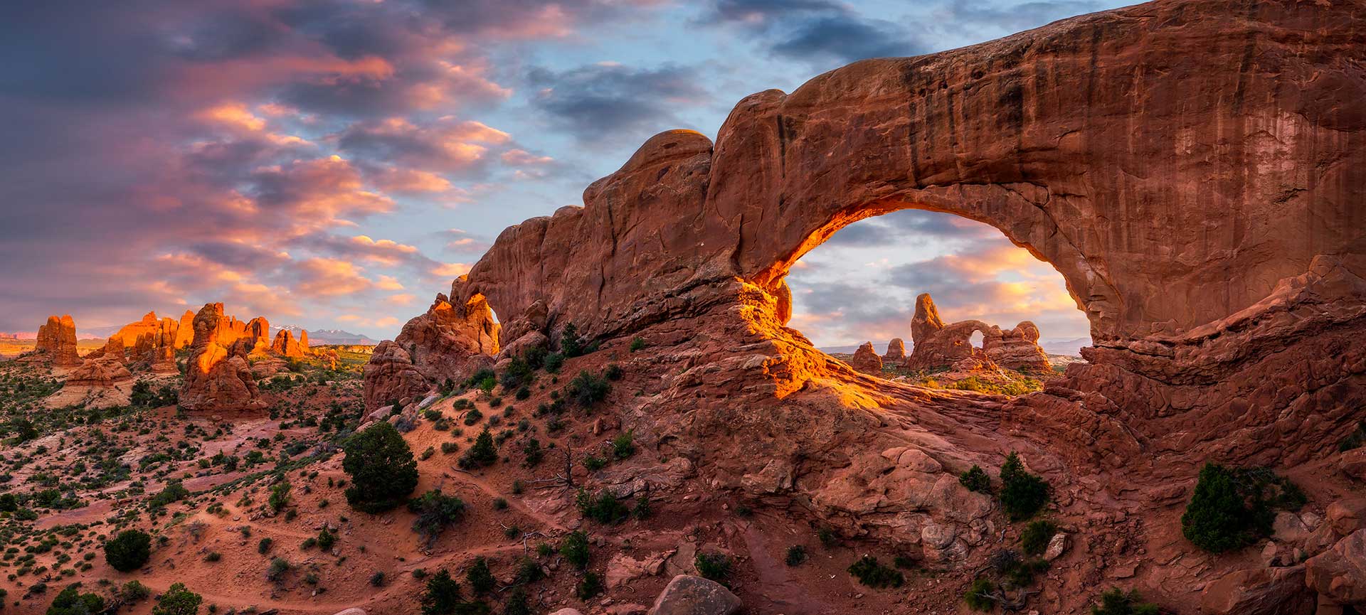
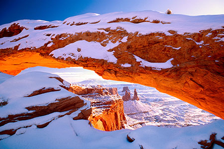
Arches National Park
The world’s largest concentration of natural sandstone arches.
Arches National Park’s Twitter page is a great source of up-to-the-minute park information. Check it out here.
Mailing Address
Arches National Park P.O. Box 907 Moab, UT 84532Visitors Center GPS Coordinates
38.616391, -109.620345Website
www.nps.gov/archMailing Address
Arches National Park P.O. Box 907 Moab, UT 84532Visitors Center GPS Coordinates
38.616391, -109.620345Websites
www.nps.gov/arch/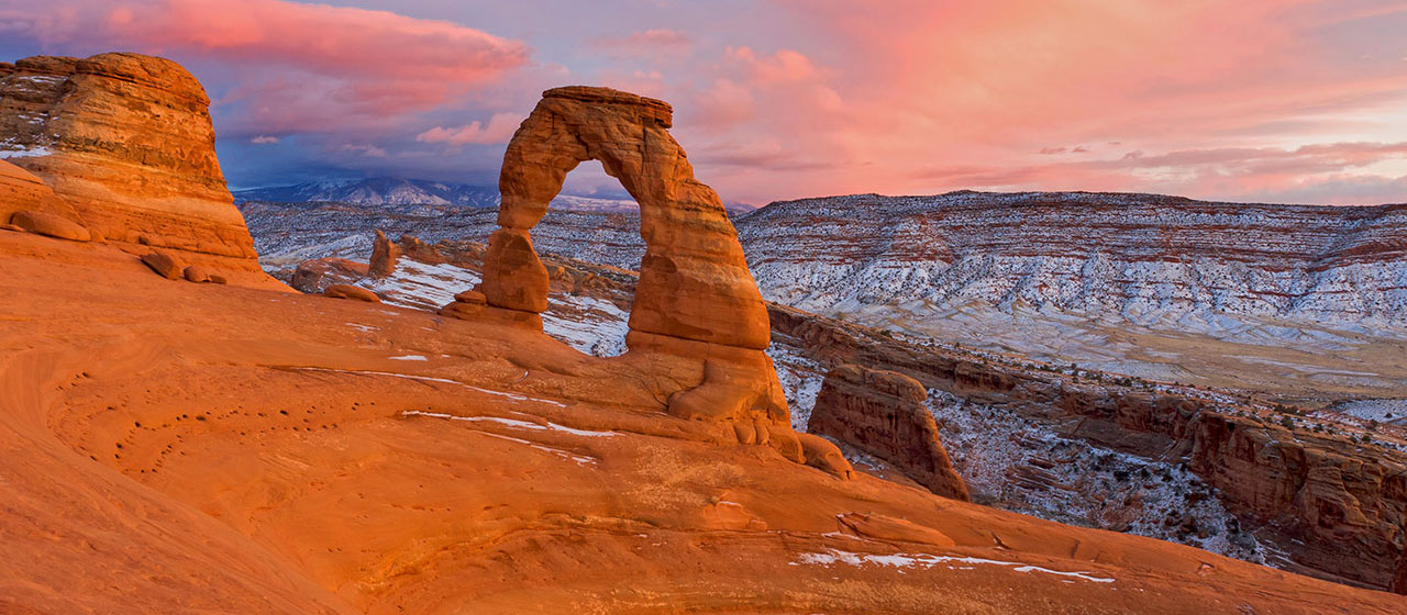

Please note that food is not available within the park. The closest restaurants are either in the town of Moab, at Dead Horse Point State Park, or at the dinosaur museum at the intersection of Highways 191 and 313 (entrance fee is not required to access the restaurant).
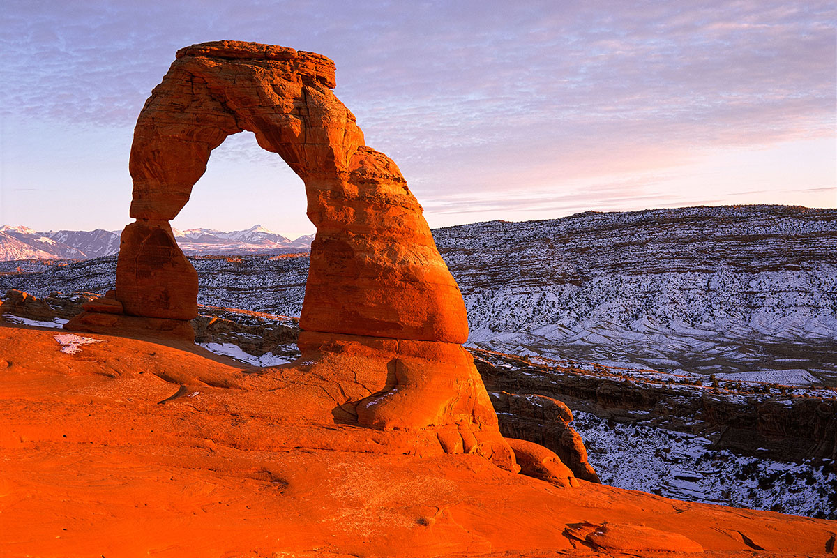
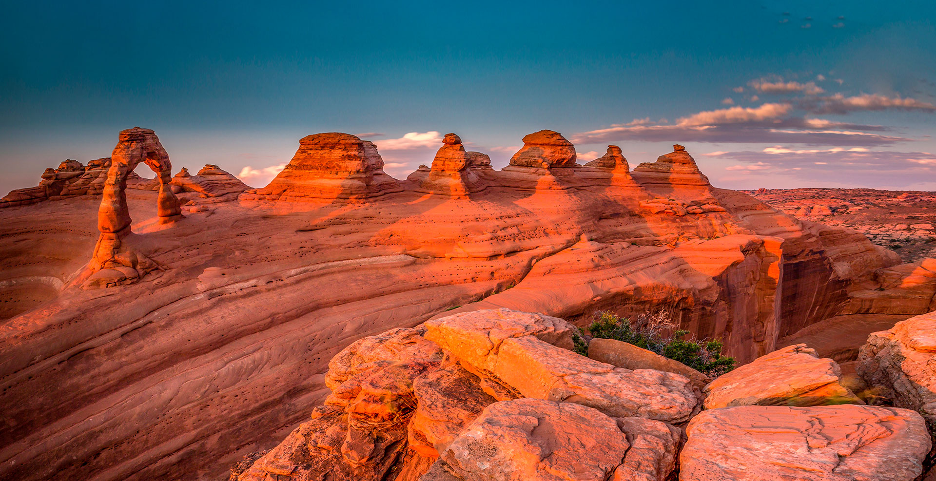
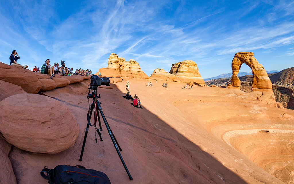
People come from all over the world to visit Arches National Park, and visiting Delicate Arch is on the top of many visitors’ to-do lists. In a park with over 2,000 stone arches, this particular free-standing arch has become a widely recognized symbol of the state of Utah and one of the most famous geologic features in the world. The light opening beneath the arch is 46 feet high and 32 feet wide, making it the largest free-standing arch in the park.
Learn More About Delicate Arch Hiking Trail
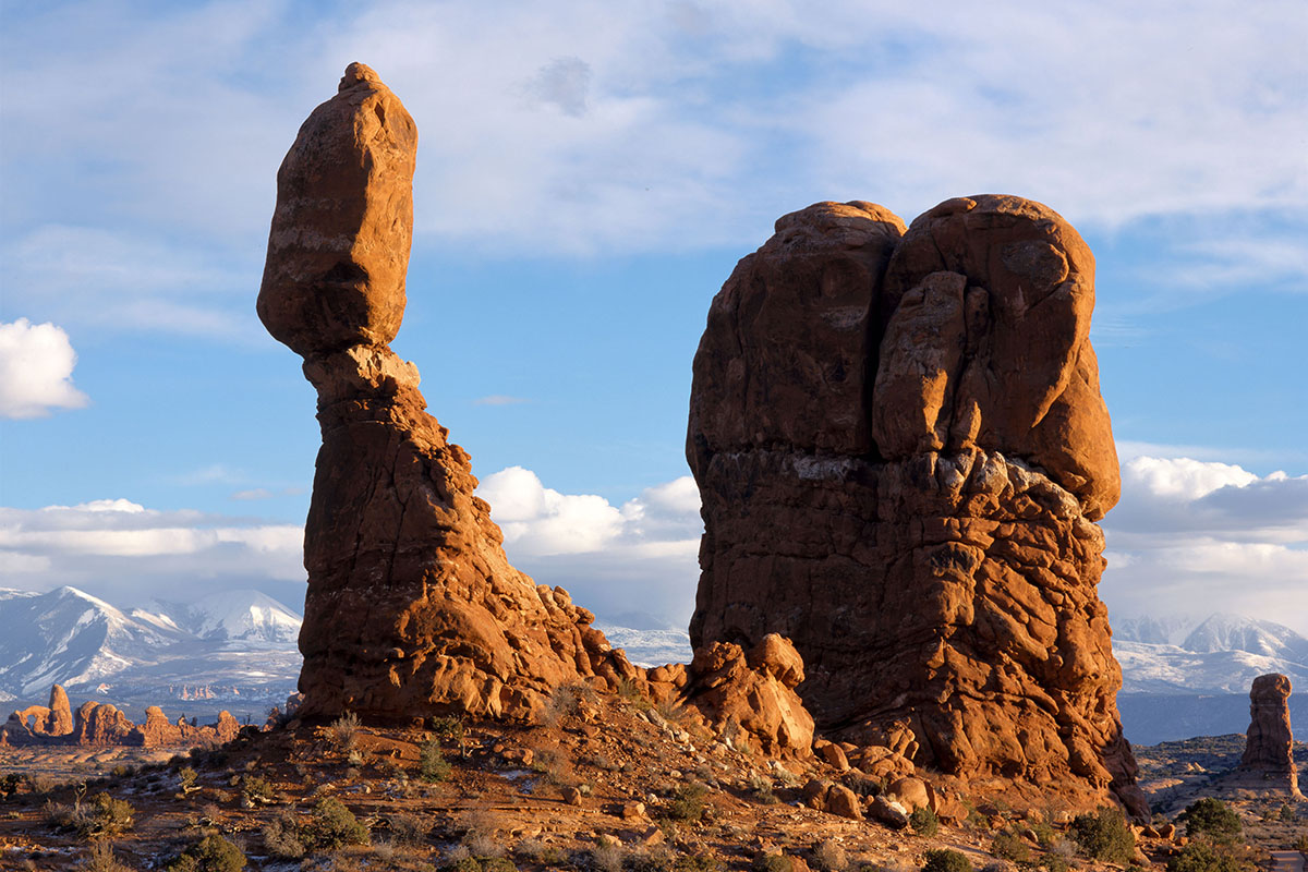
A short paved trail leads visitors to the base of Balanced Rock. The landform’s total height is 128 feet, with the huge balanced rock rising 55 feet above its base.
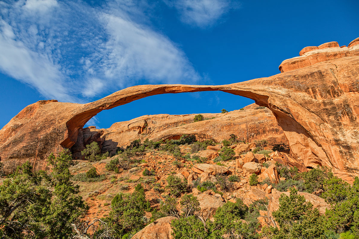
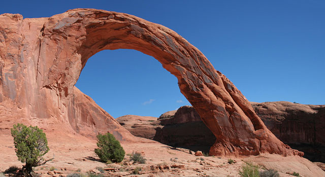
The longest natural rock span in the world, this arch’s opening is 306 feet wide – 6 feet longer than a football field. A nine story building would easily fit beneath this thin span. In 1991, a massive slab of rock fell from its underside, resulting in an even thinner ribbon of rock.
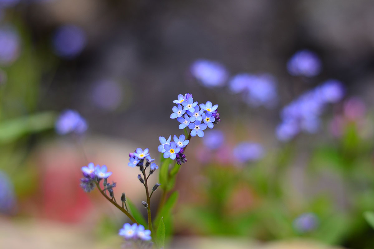
April and May bring a variety of desert wildflowers to Arches.
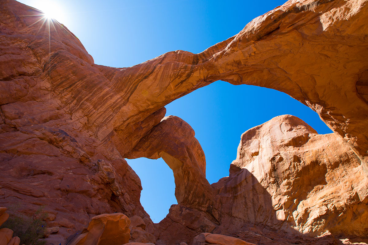
Located in the Windows Section of Arches National Park, Double Arch was used as a backdrop for portions of the 1988 movie “Indiana Jones and the Last Crusade”. Numerous other movies have been filmed in Arches National Park, including Thelma and Louise in 1991.
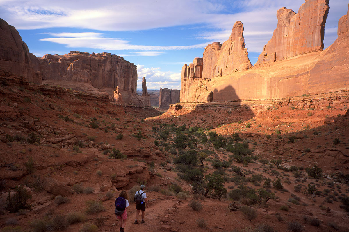
From Park Avenue parking area, the trail descends steeply into a spectacular canyon and continues down the wash to Courthouse Towers. If you have a shuttle driver, you can begin at one point and be picked up at the other. For round-trip hiking, retrace your steps along the trail rather than walk along the park road.
Winter brings a blanket of pristine snow to Arches, providing dramatic contrast to the surrounding red rocks.
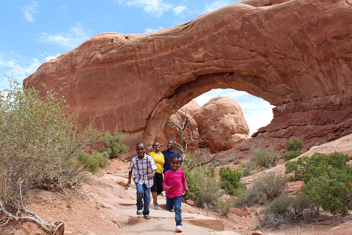
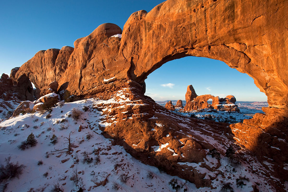
There are many family friendly hikes in Arches, including the hike to Turret Arch in the Windows Section.
Your help is crucial in preserving our trails and protecting the fragile soil that sustains the desert ecosystem. The biological soil crust, also known as cryptobiotic soil, serves as the foundation for desert plant life. This unique black, knobby crust is composed of diverse living organisms and plays a vital role in maintaining the delicate balance of the desert environment.
However, this soil crust is exceptionally delicate and can take several decades to regenerate. Even a single footstep can cause irreparable damage that can persist for years, impacting the entire ecosystem. We urge you to stay on designated roads, routes, and trails to ensure the preservation of this fragile life. In areas where hiking trails are not established, it is advisable to hike on sandy washes or bare rock surfaces to minimize the impact on the soil.
By remaining vigilant and adhering to these guidelines, you contribute to the long-term sustainability of the desert ecosystem and help safeguard its natural beauty for generations to come. Let’s work together to keep all of our trails open and protect the invaluable biological soil crust.
Try not to limit your creativity by simply capturing images of iconic places using the same composition as countless photographers before you. Arches National Park contains thousands of arches and vast expanses of breathtaking scenery just waiting for you to introduce your own personal style and interpretation. For those seeking solitude, Arches has much to offer beyond its iconic places. For example, consider a hike to Double O Arch, returning via the Primitive Trail, for some of the most spectacular scenery in the park. Just remember to bring enough memory cards to capture all of the great views!
| Early Morning | Late Afternoon |
| Moab Fault | Park Avenue |
| The Three Gossips | Courthouse Towers |
| Sheep Rock | Petrified Dunes |
| The Great Wall | Balanced Rock |
| Turret Arch | The Garden of Eden |
| The Spectacles | North and South Windows |
| Double Arch | Delicate Arch (at end of main trail) |
| Cache Valley | Fiery Furnace |
| Wolfe Ranch | Skyline Arch |
| Landscape Arch | Fins in Devil Garden |
| Double O Arch | Tower Arch |
Canyonlands Natural History Association
Canyonlands Natural History Association (CNHA) is a nonprofit organization assisting the National Park Service in its educational, interpretive and scientific programs throughout southeast Utah. Known as a "cooperating association," CNHA’s goals include enhancing visitors’ understanding and appreciation of public lands by providing a selection of quality, educational materials for sale in many vistor centers. Twenty percent of these sales is returned to the National Park Service and other federal land management agencies.
CNHA operates the bookstore at Arches Visitor Center.
Friends of Arches and Canyonlands Parks
The Friends of Arches and Canyonlands Parks: Bates Wilson Legacy Fund provides direct support to Arches and Canyonlands national parks and Natural Bridges and Hovenweep national monuments in order to enhance existing projects in these spectacular areas, and to conserve the land and its cultural treasures for present and future generations to enjoy.
This mission honors the legendary work of Superintendent Bates Wilson, who came to Arches in 1949, inspiring and leading the effort that resulted in the establishment of Canyonlands National Park in 1964. The Friends Group offices are in the Rock House behind Arches Visitor Center, where Bates once lived with his family.
Picturing Moab
From ancient images to modern pursuits, getting drawn in to Moab
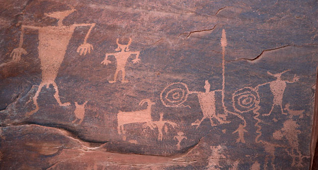
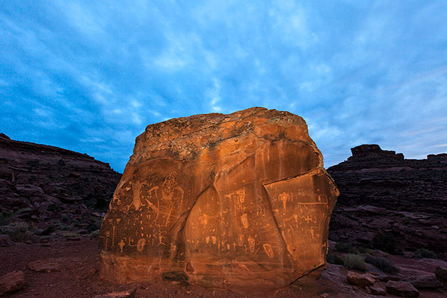
These were certainly not the kind of snapshots taken by a smart phone. Hardly. Nevertheless, back when they were created, the petroglyphs and pictographs on rock walls that I had come to study in Moab, Utah, had been state-of-the-art snapshots of life dating back as much as 3,500 years.
The renderings of spirals, herds of animals, ghostly humans and warriors armed with spears, scorpions and centipedes were primitive, yet often quite sophisticated in detail. Also, not far from Moon Flower Canyon, I found the famed Birthing Rock, depicting what is thought to be the first picture recording of human birth. We see a newborn emerging feet first from a mother’s womb.
As a professional photographer, I felt a special kinship with those long-ago artisans who either painted images using mineral and plant dyes as their medium, or who scratched and carved petroglyphs into the rock. Then, as now, the goal for image-makers has been to preserve moments in time. As I studied their often vibrant images, I couldn’t help but wonder what they were telling us.
While I was taking it all in, mountain bikers occasionally rumbled by along a web of popular stony trails. The expressions on the biker’s faces told stories of high adventure and sheer joy. Some of the more daring frequently had only air beneath their tires as they raced across the bumps and lumps in their path. They’d let out some gusty whoops as they soared. I’d come to capture Moab—what if that meant something more active?
This day, the air was crisp. Skies overhead were dazzling blue, except for some decorator clouds. As an extra added attraction, a dusting of pristine snow was draping over the upper elevations of the Colorado Plateau. All this was nature’s art in its highest form.
It’s remarkable to think that a visitor like me can not only drive around and look at this splendor, but actually become an active part of the landscape year-round with hiking, biking, 4-wheel driving and horseback riding—not to mention an infinite number of photographic opportunities.
Nearby Arches National Park and Canyonlands National Park, along with the mighty Colorado River, make this one of the most popular tourist destinations in the American Southwest.
The overall scene was breathtaking. Only minutes from the hospitable resort town of Moab, my adventure becomes a journey into antiquity. Some of the most beautiful, mineral-rich red-rock landscape on the planet surrounds me with well-defined, mostly sandstone strata revealing more than 500 million years of geologic change. Thanks to the Triassic and Jurassic periods, dinosaur footprints can be discovered by those who venture along Klondike Bluffs Trail. As a matter of fact, there are many dinosaur trackway trails that allow visitors to walk where dinosaurs walked. Further investigation can be done at a number of dinosaur exhibits at the downtown Moab Museum, or the brand new Dinosaur Park 10 miles north of Moab.
At any rate, the Klondike is technically moderate for someone in good shape, yet inexperienced in mountain biking. There I go again, talking about biking. Time to kick up a little dust.
My camera gear was the only equipment I had brought along, but, luckily, Moab bike shops offer rentals, maps, tours and moral support for those who spontaneously want to challenge the rocks, slick slopes and desert dirt. There are a range of trails, from kid-friendly to kick-butt. Yes, even in winter.
In relatively good physical shape, but still a novice mountain biker, I opt for Dead Horse Point Intrepid Trail. The name may sound a bit ominous—it’s technically mellow. Although, at times the trail seems to be saying “Don’t take me for granted, I love throwing bikers a few surprises.” It’s a 10-mile run that takes an average rider about two hours. It’s a well-defined path through sage brush, slate, rock obstacles, a few fallen trees and a couple of “hang on” downhill slopes. To be honest, I loped over a few unexpected teeth-rattling hurdles. I knew without a doubt that the endless scenery and the freeform experience would more than make up for any saddle sores I’d discover later.
This was big-wheeling like the ancients could never have imagined in their petroglyphs. One can only imagine the biker snapshots they would have carved. I still wondered about the real stories that were told on those rocks by cultures known over centuries as Paleo-Indians, Archaic, Anasazi, Fremont and most recently, Utes.
The fact is, there are no definitive interpretations of that ancient art. It is simply left to visitors who come to view it. What they do next is up to the history they’d like to create.
Bureau of Land Management Campgrounds
Elevation
Sites
RV Length
Group Sites
Picnic Tables
Boat Launch
Horse Corral
Hwy 128, 6.2 miles from Hwy 191 – Payment by cash, check or Credit Card ROK at Big Bend Campground.
Hwy 128, 6.6 miles from Hwy 191 – Payment by cash, check or Credit Card ROK at Big Bend Campground.
Hwy 128, 6.9 miles from Hwy 191 – Payment by cash, check or Credit Card ROK at Big Bend Campground.
Hwy 128, 7.4 miles from Hwy 191 – Payment by cash, check or Credit Card ROK at Big Bend Campground.
Hwy 128, 8.1 miles from Hwy 191 – Payment by cash, check or Credit Card ROK at Big Bend Campground.
Hwy 128, 21 miles from Hwy 191, then 0.7 miles southeast on gravel road. Has corral for up to 8 horses. Payment by cash, check or Credit Card ROK at Hittle Bottom Campground.
Hwy 128, 21.5 miles from Hwy 191 then 1 mile northwest on graded road. Payment by cash, check or Credit Card ROK at Hittle Bottom Campground.
Hwy 128, 21.5 miles from Hwy 191 – Dirt Road access. Payment by cash, check or Credit Card ROK at Hittle Bottom Campground.
Hwy 128, 22.5 miles from Hwy 191 – Payment by cash, check or Credit Card ROK.
Hwy 128, 28.7 miles from Hwy 191 – Payment by cash, check or Credit Card ROK at Hittle Bottom Campground.
Utah 313, 12 miles from Hwy 191 – Payment by cash, check or Credit Card ROK.
Kane Creek Rd, 2.8 miles from Hwy 191 – Payment by cash or check.
Kane Creek Rd, 7.8 miles from Hwy 191 – Dirt road access. Reservable only through Recreation.gov.
The Ledge A, B, C, D, & E Campgrounds
Kane Creek Rd, 10 miles from Hwy 191 – Access to the Ledge Campground is down a tight, steep switchback and over several creek crossings on a gravel/dirt road. It is not recommended for vehicles over 22′ or vehicles pulling long trailers. – Payment by cash or check.
8.5 miles south of Moab off Hwy 191, then follow signs south on Spanish Valley Drive. Ken’s Lake Campground is now reservable via Recreation.gov.
16 mi north of Moab on Hwy 191, then approximately 1 mi on the graveled Mill Canyon Road (turn left at first “Y” on road). Large graveled parking area suitable for large RVs and/or trailers. Campsites 1-4 and 7-10 cash, check, scan and pay. Campsites 5 and 6 reservation only through Recreation.gov.
22 mi north of Moab on SR 191, take the graveled Road 143 and past the metal toilet (stay left at first “Y” on road). This campground also has the option to pay using the Recreation.gov mobile app.

Within 20 miles of Moab, camping is only allowed in developed campgrounds.
Primitive camping is available in certain areas outside of Moab (see map & legend below): These regulations apply to all primitive sites:

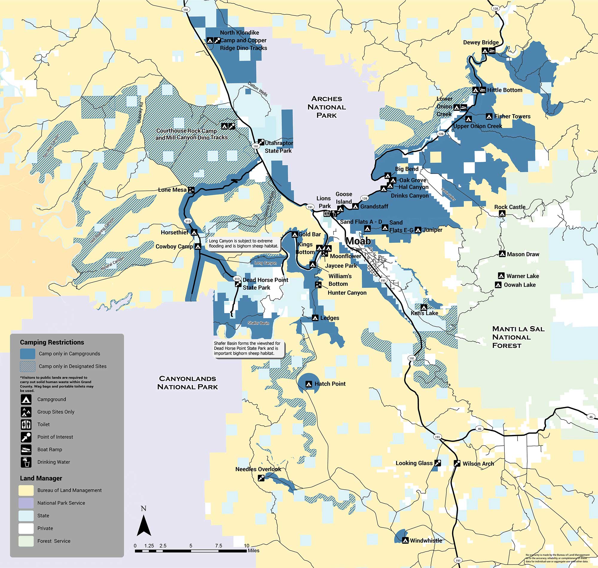
The areas with designated sites (marked with green hatch lines) are summarized below:
There are several areas in which no sites are designated and camping is not allowed (orange). The Shafer Basin, which forms the viewshed of Dead Horse Point State Park and is important bighorn sheep habitat, has no sites. Long Canyon, which is subject to extreme flooding and is also important bighorn habitat, has no sites. No camping is allowed in the Mill Creek area immediately east of the city of Moab, or on the west side of Spanish Valley. No camping is allowed within one mile of developed recreation sites in the Canyon Rims Recreation Area. If you have any questions about primitive camping restrictions please contact the Moab BLM Office at (435) 259-2100.
Introducing the Moab Outdoor Adventure Guide—a comprehensive resource showcasing the diverse range of adventures and activities awaiting you on the public lands surrounding Moab. Whether you’re drawn to hiking, off-road driving, river activities, scenic byways, dark sky observing, mountain biking, e-biking, rock art tours, camping, dinosaur trails, or exploring with your furry companions, this guide is your ultimate companion.
The Moab Outdoor Adventure Guide is now available, free of charge, at the Moab Information Center located at the corner of Main and Center Streets in Moab. For your convenience, an ebook version is also available for download. To access the guide online and embark on your virtual exploration, simply Click here.
This comprehensive guide is designed to lead you on the right path, ensuring you make the most of your Moab adventure. Discover the countless possibilities and make memories that will last a lifetime. Get your copy of the Moab Outdoor Adventure Guide today and let the excitement begin!
Guides, Outfitters and Services
Search for Guides, Outfitters, Services and Equipment Rentals
Select all that apply and scroll down to see companies that offer the service(s).

Moab Road Biking
Information courtesy of Poison Spider Bicycles