

Potash-Lower Colorado River Scenic Byway (U-279)
- Distance
- 17 ml
- Duration
- 1 hr
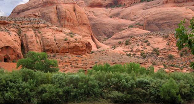
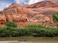
This Scenic Byway provides great views of the Colorado River, ancient rock art and dinosaur tracks. A late afternoon start is rewarding as the sunset on the reddish-orange sandstone cliffs along the route is especially beautiful on the return drive to Moab. This byway begins 4.1 miles (6.6 km) north of Moab, where Potash Road (U279) turns off of Highway 191. After 2.7 miles (4.3 km) Potash Road enters the deep gorge of the Colorado River. At the 4 mile (6.4 km) point, look for rock climbers on the cliffs along the section of Potash Road, locally referred to as Wall Street.
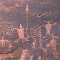
At 5.1 miles (8.2 km) several petroglyph panels are visible on cliffs on the right side of the highway. Marked pull-offs on the left side of the road provide parking to view these panels. An interpretive sign provides additional information. At 5.9 miles (9.5 km) the Poison Spider Trail Parking will be on the right. A kiosk on the end of the parking lot, near the vault toilet, will have a map for a short trail to dinosaur tracks and rock art. Trailhead parking for the trail to Corona and Bowtie Arches is available at 9.9 miles (15.9 km). Corona Arch, with an opening of 140 by 105 feet, is also known as Little Rainbow because of its resemblance to Rainbow Bridge at Lake Powell.
 Look for Jug Handle Arch, adjacent to the highway, at 13.5 miles (21.7 km). Shortly beyond Jug Handle Arch, the canyon widens and the sheer cliffs below Dead Horse Point State Park become visible in the distance. The paved highway ends at the Intrepid Potash Mine where potash, a mineral often used as a fertilizer, is extracted by flushing large volumes of water through an extensive system of underground tunnels and then evaporating the water in ponds. From the end of the byway drivers with high clearance vehicles can continue on a dirt road to Canyonlands National Park.