


Moab Road Biking
The secret is out…and skinny tires are in! Whether you ride for fun or like to push the pace for training, Moab has some of the best road bike riding in the West. Our paved roads generally have little traffic and the terrain varies from mild to wild, with flats, rolling hills and steep sections to really get your heart pumping. You won’t find a more scenic place to ride!
Our year-round weather is ideal. In summer, ride early in the day and enjoy the cool breeze you generate as you pedal along. In winter, our sunny days and low precipitation make for ideal riding conditions to stay in shape and get a jump on the competition. Spring and fall in Redrock Country are legendary for their mild temperatures and perfect conditions. However, our weather conditions can change at any time of year so check the local forecast, carry appropriate clothing and bring plenty of water and snacks.
Resources
Biking Routes
Colorado River Ride – (a.k.a.) The Potash Road
Back to Top of List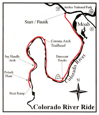
Length
33.4 miles total – out and back to the Colorado River boat ramp.
Start
Junction of Hwy 191 and 279 (4 miles north of Poison Spider Bicycles). To shorten this ride, drive in a few miles to any of the numerous parking places along Hwy 279.
This beautiful ride follows the Colorado River and has only one small rise near its start at the junction of Hwy 191 and 279. Its relatively flat profile makes it a great training ride for speed work and a perfect family ride, too. Along the way you’ll pass Wall Street, a popular climbing area where you can watch climbers scaling vertical sandstone walls. Within a mile are two roadside signs pointing to some of the finest petroglyphs in the Moab area, and there are other rock art panels along the way – so keep an eye out. If this isn’t enough, there is also a roadside pullout to view dinosaur tracks, and farther downstream is the aptly named Jug Handle Arch, over 46 feet high and only 3 feet wide. The ride then passes the Moab Potash Plant, where large domed buildings house this snow-white mineral used in making fertilizer. In a little over a mile the ride and the pavement end at the Colorado River boat ramp, a nice spot to stop for a snack before you turn back and retrace your route.
(No Elevation profile – Flat ride)
La Sal Mountain Loop Road
Back to Top of List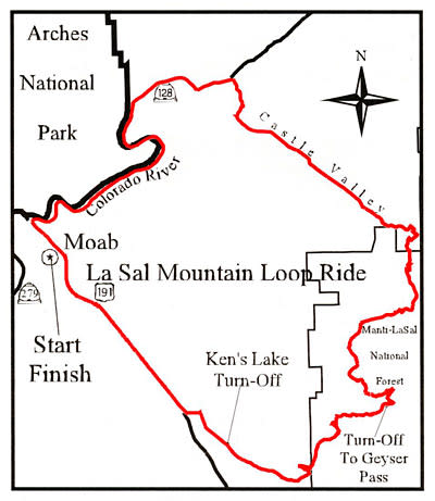
Length
62 mile loop (can be ridden either direction)
Start
Poison Spider Bicycles
This tour has it all – beautiful redrock canyon scenery and stunning alpine vistas of the La Sals, the second highest mountain range in Utah. To avoid heavy traffic, get an early start and head north on the bike path paralleling Hwy 191. Turn right onto Hwy 128 and follow the gorgeous winding Colorado River for 21 miles before turning into Castle Valley. You’ll climb through Castle Valley with its famous rock pinnacles; The Priest and Nuns, and Castle Rock while looking at the La Sal Mountains. Then begins the steep climb into the mountains and aspen groves by turning onto the La Sal Loop Road. The climb is strenuous but the scenery is outstanding! After cruising along the top of the world at 8,000 feet, reap the rewards of your efforts and get a 20 mile, nonstop descent back Moab!
(Note: Hwy 128 has no shoulder, many blind corners, and experiences heavy traffic all day. If biking on this road, it is best to start very early to avoid traffic and to have a tail light and/or other visibility).
Needles Overlook and Canyon Rims Recreation Area
Back to Top of List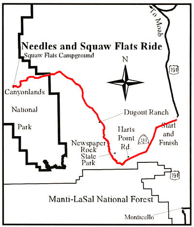
Length
Up to 79 miles round trip – out to Big Spring Canyon Overlook and back
Start
Junction of Hwy 191 and 211 (39.2 miles south of Poison Spider Bicycles). For a shorter ride, we suggest driving farther in on Hwy 211 and parking either at Newspaper Rock (mile 12) or near Dugout Ranch (mile 19). User fee or a Park Pass is required in the National Park.
This tour takes the rider past Newspaper Rock, one of the west’s most outstanding displays of Native American rock art. As you’re riding, look for other etched panels of rock art on the right side. Farther along are the world-famous Indian Creek climbing area and the historic Dugout Ranch, one of the first ranches in southeastern Utah that is now owned by The Nature Conservancy. Rock formations abound including the picturesque Six Shooter Buttes and the red and white sandstone spires of the Needles District. You’d think you were in a John Wayne movie! If you have time, explore the numerous hiking trails of the Needles District.
Canyonlands National Park – Island in the Sky
Back to Top of List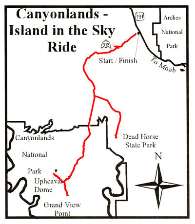
Length
Up to 70 miles to Grand View Point and back.
Start
Junction of Hwy 191 and 313 (9 miles north of Poison Spider Bicycles). To avoid most of the climbing drive farther up Hwy 313 and park at the Island in the Sky Visitor Center to make it a 24.5 mi. round trip. User fee or a Park Pass is required in the National Park.
The ride begins with a gradual ascent through the Moab Fault, a sandstone cliff band that forms the western edge of the Moab Valley. As you climb, look back to the east for great views of Arches National Park. Once you reach the top of this long steady climb the panorama is breathtaking – three mountain ranges (the Henrys, Abajos and La Sals), the Needles and Maze, the Colorado and Green River Canyons and the Book Cliffs. The ride turns around at Grand View Point, where you look out over Monument Basin and the White Rim. For additional riding, the 10 mi. round trip to Upheaval Dome is well worth the effort.
Trail of the Ancients – The Road to Natural Bridges National Monument
Back to Top of List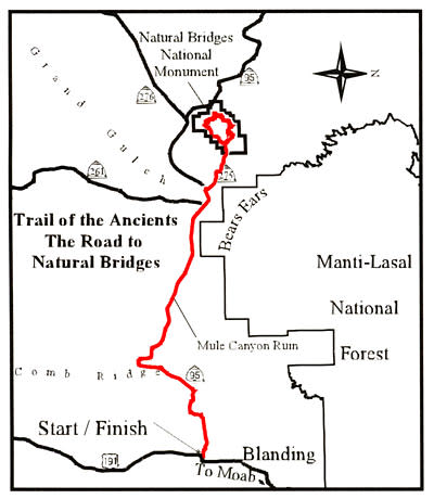
Length
Up to 79 miles to Natural Bridges Natl. Monument and back.
Start
Junction of Hwy 191 and 95 (80 mi. south of Moab and 4 mi. south of Blanding). This challenging ride can be shortened by parking at the Mule Canyon Ruins (20 mi. from Hwy 191). User fee or a Park Pass is required in the National Monument.
The Trail of the Ancients travels across the Cedar Mesa, an area extremely rich in archeology. Mule Canyon Ruins, an easily accessible site, comes shortly after crossing Comb Ridge. The highlight of the ride is the loop through Natural Bridges National Monument. The 8-mile-long Bridge View Drive offers overlooks and access to all three bridges. Unless you are a strong rider, you may want to shorten the ride to have time to explore this unique area. An interesting side note is that the funding for this highway across the Cedar Mesa came from a Utah Bicentennial Highway Grant. This large wilderness area had previously been very remote. The highway project generated heated controversy between developers and environmentalists and inspired Edward Abbey’s novel “The Monkey Wrench Gang.”
The Blue Mountain Loop
Back to Top of List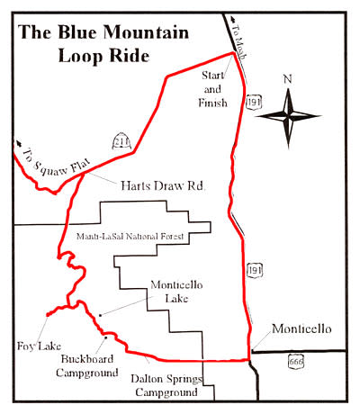
Length
42 mile loop
Start
Junction of Hwy 191 and 211 (39.2 mi. south of Poison Spider Bicycles). For those who want to avoid riding Hwy 191 at the end of the ride, you can shuttle a car to Monticello, or do this ride as an out and back.
From the junction of Hwy 191 and 211, ride 9 1/2 mi. west on Hwy 211 and turn left (south) on the paved road marked Harts Draw (another starting point for a shorter ride). This road climbs steadily into the Abajo Mountains and reaches a high point a little over 8,800 ft. The views looking back over the Indian Creek area and north to the La Sal Mountains are spectacular. In the fall the trees erupt in a kaleidoscope of color. After reaching the top and cruising along through the pines and aspens, the road drops sharply down into Monticello. From this highpoint you may also elect to turn around and return on the same route to avoid riding on Hwy 191 or dealing with a car shuttle.
La Sal Junction to the Dolores River
Back to Top of List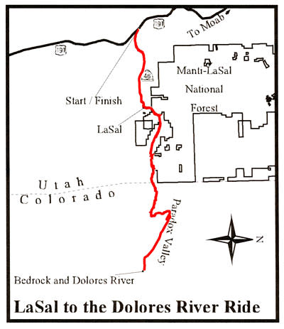
Length
Up to 75 miles round trip to Bedrock, Colorado, and back.
Start
Junction of Hwy 191 and 46 (22.3 miles south of Poison Spider Bicycles.) This ride can be shortened by turning around at Upper Two Mile Rd. (the high point of the ride at 7,732 ft.) or by driving farther east on Hwy 46 and starting at the La Sal post office and riding to the end of the beautiful La Sal Creek Canyon and back.
This scenic ride has many different faces. You start by climbing the south side of the La Sals with Mt. Peale, the tallest peak at 12,721 ft., coming into view at Mile 13 near the high point of the ride. You’ll then descend into La Sal Creek Canyon and cross the state line into Colorado. After another short climb you’ll descend into the Paradox Valley to Bedrock on the Dolores River. The Dolores, like the Colorado River near Moab, cuts across the valley rather than running down along the valley floor. This geological anomaly inspired the name Paradox. The historic country store at Bedrock is a welcome sight at the turn around point of this ride.
Bike Safety
The Moab area offers challenging riding amidst world-class scenery. The characteristics of the area that make it a special place for riding also make it extremely important to follow basic safety procedures.
Wear a helmet
Road conditions are variable. Even the best riders can get tired and make mistakes. Helmets can prevent or reduce the severity of head injuries.
Carry lots of water and high-energy food.
At least a gallon of water is recommended per person per day. There very few opportunities to refill water and summer temperatures often climb above 100 degrees Fahrenheit. Running out of water will put your health at risk. Eating at intervals provides an opportunity to rest and the energy needed to complete the ride.
Carry trail maps and know how to use them to track your position
Detailed topographic and road maps are available in Moab at bike shops, bookstores and the Moab Information Center. Cellphone service is very limited and cannot be relied upon to navigate.
Stay found, save money.
Grand County has one of the highest incidences of Search and Rescues in Utah. The high cost of these operations is normally the responsibility of the rescued party. If you decide that you have lost the trail, do not continue on in hopes of finding your own way. Retrace your route back towards the trailhead until you pick up the trail, find someone who knows the area, or return to the trailhead. If you cannot retrace your route, stay put, conserve energy and water, make yourself visible and await rescue. It’s always a good idea to let a friend or relative know beforehand where you are going and when you should return. If something goes wrong you have the comfort of knowing that they will get help.
Check your bike frequently.
Riding in Moab loosens headsets and puts maximum stress upon frames and components. Frequent inspections reduce the possibility of injury. Be prepared in case of emergency.
Don’t venture into remote areas with nothing but a t-shirt and shorts.
Carry a windbreaker, sunscreen, sunglasses, maps, matches or lighter, pump, patch kit, first-aid kit, a good bike tool kit and extra food, water and clothing.
Ride with someone else and stay together in case of problems.
Discuss your situation calmly and make a plan to improve it.
Practice good road safety and etiquette.
Many of the roads in the Moab area have little to no shoulder, many blind corners, and lots of traffic. Make yourself visible with bright colored clothing and tail lights. Be aware and courteous of drivers. Move over to lets cars pass when safe.
Vehicle Bike Rack Rentals
The following Moab companies rent vehicle bike racks: