


Moab Mountain Biking
Moab is home to the greatest mountain biking on the planet
Welcome to Moab, home to some of the best mountain biking trails on the planet. Whether you’re a beginner or a seasoned biker, there’s something for everyone here. With a vast array of trails to choose from, Moab offers stunning rides through canyons and mesa tops, as well as challenging routes that will push your skills to the limit.
One of the most famous trails in Moab is the Slickrock Bike Trail. At 9.6 miles, it’s a highly technical ride that’s considered the ultimate mountain biking experience by many. But don’t worry if you’re not ready for that level of challenge yet. Moab also offers an assortment of easier trails that are no less beautiful. Take the Bar-M Loop Trail, for example, which provides a great introduction to the varied terrain and stunning scenery near Arches National Park.
Explore this page to plan your own mountain biking adventure and experience the thrill of riding through Moab’s breathtaking landscapes.
Moab’s extensive and challenging trail system is unlike any other in the world.
The National Ability Center can help people of all ability levels access Moab’s world famous mountain biking trails.
Moab Mountain Biking Trail Summary
Guided Tours/Bike Rentals
Need to rent a bike, or set up a guided bike tour? Moab has a huge variety of mountain biking guides & outfitters. Click here to check out our complete list of what is available in Moab.
Route Recommendations
Amasa Back Area
Back to Top of List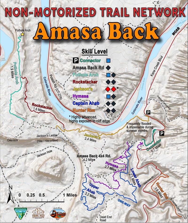
-
Length:
3.8 miles from Kane Creek Rd (one-way)Difficulty:
Physically challenging, technically moderate/difficult. Total climb is about 1410 feet. Average grade is about 10%.Type of Ride:
Ledgy 4WD road. The Amasa Back Trail is a jeep trail that climbs about 1000 feet to a mesa top overlooking the Colorado River and the Kane Creek Anticline. The trail surface is mostly Kayenta Sandstone and has many small ledges (less than 1’) and a few bigger ones. Challenging and fun for experienced mountain bikers only a short bike ride from town. Follow Kane Creek Rd for 5 miles; Amasa Back parking is the second lot after the pavement ends. The jeep trail leaves the road less than a mile later. -
Length:
2.4 milesDifficulty:
Physically demanding, technical, for advanced riders. Total climb of approximately 1200 feet. Average grade is about 14%. Trail along cliff edge in places.Type of Ride:
Start the trail at the Kane Ck parking area just beyond the end of the pavement. Consult the map sign at the trailhead. Kane Creek may be flooded and difficult to cross. After crossing Kane Creek you will start a steep climb up a talus slope overlooking the Colorado River. The trail is narrow and gets close to cliff edges in a few places. Rockstacker trail intersects Jackson Trail about 1/4 mile before it ends at Cliff Hanger Road. -
Length:
1.6 milesDifficulty:
For advanced riders. Physically demanding and technically difficult. You will climb about 500 feet going up to the Pothole Arch Trail. Average grade is about 11%.Type of Ride:
This trail connects the Jackson Trail and the pot Hole Arch trail. Start the trail where it intersects the Jackson Trail. Ride is mostly sandstone with a couple of steep climbs before reaching Pot Hole Arch trail. Surface is smooth and bumpy sandstone, with narrow ledges and sharp turns on one climb. -
Length:
1.9 milesDifficulty:
Intermediate to advanced riders. Physically demanding. Total climb going to the arch from Cliff Hanger is approximately 230 ft. Total climb going from the arch back to Cliff Hanger is approximately 500 ft. Average grade is about 7%.Type of Ride:
Start the trail at the Cliff Hanger Rd. Surface is sandstone, then dirt across a flat mesa, then slickrock hills out to the arch. Rockstacker Trail intersects Pot Hole right before the dirt mesa. -
Length:
4.3 milesDifficulty:
Physically demanding, technical, for expert riders. Bottom half of the trail is one-way. The trail is not all downhill. Even though the trail starts at an elevation of about 4700 ft and ends at about 4000 ft, you will still have to climb about 1000 ft in order to descend more than 1600 ft. Average grade about 11%. Trail is along cliff edges in places and has a plethora of technical challenges.Type of Ride:
You must ride up the Cliff Hanger jeep road about 2 miles to gain access to the start of Ahab (~700 ft climb). You can start at the mid-point of Ahab by turning left after 1.7 miles on the road. The ride is on slickrock, ledges, dirt veneer of the Kayenta Formation and offers grand views of Behind The Rocks and the La Sal Mountains. -
Length:
2.7 milesDifficulty:
Physically demanding, technical, for seasoned intermediate and advanced riders. Trail was designed as a singletrack climbing route to the top of Captain Ahab. Uses Amasa Back road briefly to cross the creek and get up the switchback. The singletrack to the top of Ahab climbs about 600 ft. Average grade is 13%.Type of Ride:
Ride up or down. Begins at Kane Creek road and offers an alternate to the jeep road down to Kane Creek. Ride across the creek and up past Ahab exit to top of switchback before starting second part of the singletrack. The track crosses the Amasa Back road 3 times and the Minesweeper road once.
Dead Horse Point State Park
Back to Top of List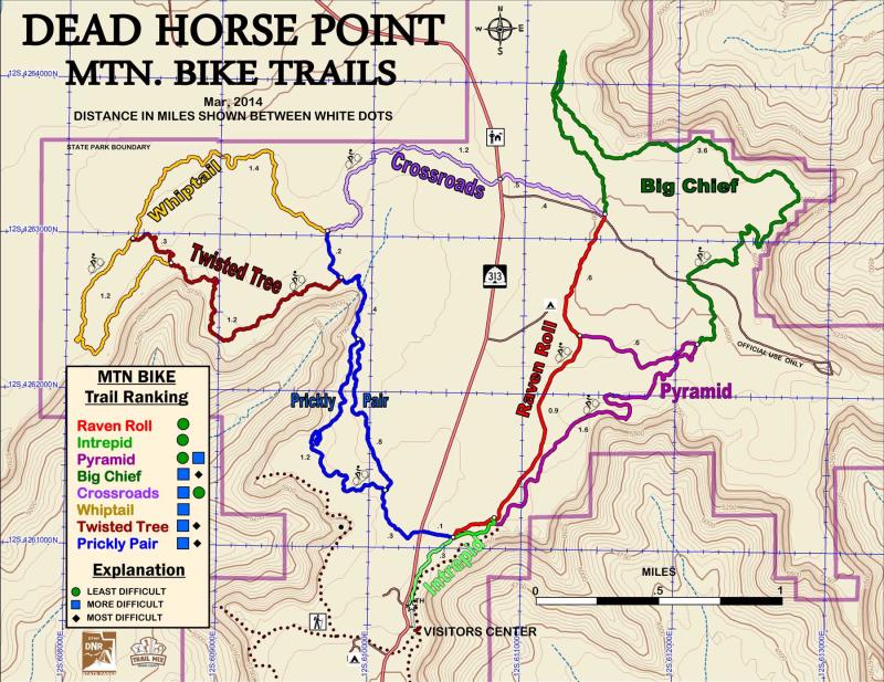
-
Length:
0.5 milesDifficulty:
EasyType of Ride:
Great family ride with tremendous views of the Colorado River Canyon -
Length:
2.2 milesDifficulty:
Easy riding but a bit more strenuous and roughType of Ride:
An longer extension of the Intrepid trail offering more great views and featuring the Great Pyramid -
Length:
3.6 milesDifficulty:
Easy. This section is flat and returns you to the Intrepid trail and the visitor’s center.Type of Ride:
Long straight-away on hard packed surface. -
Length:
1.7 milesDifficulty:
Easy. This section is flat and returns you to the Intrepid trail and the visitor’s center.Type of Ride:
Long straight-away on hard packed surface. -
Length:
1.7 milesDifficulty:
Lower intermediate riding descending slightly. Some mild rough spots at wash crossings.Type of Ride:
This trail takes you into the far west sections of the Park with breath-taking overlooks into Shafer Canyon. -
Length:
2.6 milesDifficulty:
Solid intermediate riding with mild climbs and descents. Some ledgey stretches as it tracks along sandstone outcrops.Type of Ride:
This trail takes you into the far west sections of the Park with breath-taking overlooks into Shafer Canyon. -
Length:
1.5 milesDifficulty:
Intermediate with a few advanced moves. Rough sandstone stretches, steep swooping turns and some moderately tight turns to cross over sandstone benches.Type of Ride:
Starts off of Whiptail with a fast descent toward the cliff. Ledges and switchbacks keep it interesting as you glance toward the looming cliff of Shafer. Sandstone is rough but offer great traction for the short climbs. -
Length:
3.0 milesDifficulty:
Intermediate with a few advanced twists. The west trail is more prickly and longer than the east trail, but both are fun.Type of Ride:
Twists and turns, climbs and descents, prickly pear forests, and views into the chasm named West Shafer. Trail crosses SR-313 and ends at the Intrepid trail near the visitor’s center.
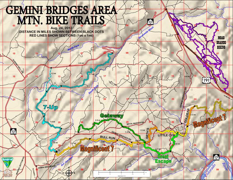
Gemini Bridges Road & Beyond
Back to Top of ListThe Magnificent 7-This system of trails/roads currently has 2 options: Using the Portal Trail to end at SR-279 or Using the Poison Spider 4×4 road as the exit to SR-279.
-
Length:
5.1 miles of singletrack; short section on seldom used road and on Gemini Bridges Rd.Difficulty:
Intermediate plus riders. Several sections of the trail are near a cliff edge so controlling your speed is advised. Total climb from Mag 7 TH to Arth’s Corner is about 600 feet. Total climb coming back is 1250 Feet. Average grade about is 6%.Type of Ride:
This is the 1st trail in the Mag 7 system. Start the trail at the Mag 7 Trailhead on the Gemini Bridges Rd about 1.6 miles from SR-313. The ride is mostly on sandstone (Kayenta Fm) through a Pinion and Juniper forest. Views of the La Sals, Behind The Rocks, & Bull Canyon are stunning. Stay on the trail. -
Length:
1.5 milesDifficulty:
Intermediate plus riders. Moderately technical. Average grade is about 5%.Type of Ride:
This is the 2nd trail in the Mag 7 system. Start the trail at the Arth’s Corner TH or continue from Bull Run ride that ends here. Surface is mostly sandstone thru Pinyons and Junipers. Follow the paint marks carefully. Stay on the trail to protect microbiotic soil gardens. Last short section of trail is on Metal Masher 4×4 road to the beginning of Little Canyon singletrack. -
Length:
2.2 milesDifficulty:
Intermediate plus riders. Moderate technical. Total climb about 150 feet. Total climb coming back about 450 feet. Average grade is about 5%.Type of Ride:
This is the 3rd trail in the Mag 7 system. Surface mostly sandstone; terrain Pinion and Juniper forest. Traverses drainages, ridges, and broad ledges. One short steep descent into Little Canyon Wash. Great views. -
Length:
1.2 miles of singletrack and 2.3 miles of 4×4 road to the rim. (typically ridden as an up and back on the singletrack since continuing on Mag 7 involves negotiating difficult 4×4 roads.Difficulty:
Intermediate plus riders; aerobically demanding. Moderately technical. From the end of Little Canyon ST to the overlook of Bride Canyon is a 400 ft climb. Average grade is about 8%. The ride on roads to the rim has an average grade of 12% with a climb of 957 feet.Type of Ride:
This is the 4th trail in the Mag 7 system. Start the trail at the Gold Bar Rim 4×4 road (end of Little Canyon ST). Surface is all slickrock along shallow drainages. Numerous interesting turns, drops, and climbs over and along ledges and thru boulders. Last section on massive sandstone features an arch just before reaching the rim of Bride Canyon. Take a break and see if you can identify the Bride & Groom. The road to the rim is physically demanding; mostly on slickrock with the typical rubble found on 4×4 roads. -
Length:
Currently this is 5.2 miles of nasty 4×4 roads.Difficulty:
Intermediate to advanced riders; physically demanding. Moderately technical. From the intersection with the Golden Spike 4×4 road to the beginning of the Portal you will climb approximately 1470 feet. Average grade about is 12%.Type of Ride:
This is the 5th trail in the Mag 7 system. Start the trail at the intersection of the Gold Bar Rim road and the Golden Spike road. Surface is slickrock, sandstone rubble, and sand. Views of the river and Spanish Valley where the road is near the rim. Take plenty of water and food. This is a trek. -
Length:
Currently 7.4 miles of rough 4×4 road.Difficulty:
Intermediate plus to advanced riders; physically challenging. Moderately technical. From the Portal Trail start to SR-279 you will descend more than 1000 feet, but still climb about 550 feet over numerous hills & ridges. Average grade is about 5%.Type of Ride:
This is the 6th trail in the Mag 7 system. Start the trail at the top of the Portal Trail. Surface is a mixture of steep slickrock and deep sand. Surface has been thoroughly churned up by motorized vehicles so can be quite rough and powdery in places. -
Length:
2.6 milesDifficulty:
Advanced to expert riders. The descent to SR-279 is about 1050 feet. The trail starts on a very dangerous cliff which has been the site of several fatalities. Be extremely careful at this point. The trail then dives down a wide ledge of Kayenta Formation. The trail is very steep and rough, with an average grade of about about 23%. Use the Poison Spider option if you are uncertain about your skill level.Type of Ride:
This is the 7th & final ride of the Mag 7 system. Moab is in sight but the trail must be your only focus and survival must be your only goal. Please use extreme caution! -
Length:
3.3 milesDifficulty:
Intermediate and above skill level. Average grade about 8%.Type of Ride:
Start the trail across from the Arth’s Corner TH. Surface is mostly sandstone through Pinyons and Junipers. Follow the paint marks carefully. Trail crosses Bull Canyon Rd at the halfway point; a good bailout if the trail is more than you want. In the 2nd half the trail crosses a dry wash then proceeds along rock shelves to another dry wash crossing where you must hike your bike. Stay on the trail to protect microbiotic soil gardens. Trial intersects Little Canyon ST about 1/2 mile before it ends. Turn left to return to Arth’s Corner Trail or turn right to proceed to Gold Bar ST. -
Length:
4.4 milesDifficulty:
Intermediate skill level. Average grade about 3%.Type of Ride:
Start the trail off of the Gemini Bridges Road about 1.5 miles down (east) from the Mag-7 Trailhead. Follow the paint marks and signs on a 4×4 road to the start of the singletrack. This downhill trail loses about 330 feet of elevation from start to finish, but gives you 610 feet of descent and 280 feet of climb. Great views of Monitor and Merrimac Buttes and the Sevenmile Wash canyons. The trail crosses Metal Masher jeep road and other 2-tracks several times before reaching Arth’s Corner trailhead. This allows numerous points to bailout and return to Gemini Bridges road and your car. -
Length:
9.5 milesDifficulty:
Intermediate and above. Average grade about 5%.Type of Ride:
Start the trail at the Mag-7 Trailhead. Surface is mostly broken sandstone thru Pinyons and Junipers and a seldom used 4×4 road. Three ST go-arounds are provided to avoid particularly difficult road sections (ledges & sand). Follow the paint marks carefully. Trail makes its way across the upper reaches of Sevenmile Canyon then flows along a Kayenta Fm bench below towering Navajo Ss mounds before ending at the SR-313 switchbacks. Ride the pavement back to US-191, Moab Brands, and then Moab (about a 25-mile ride). -
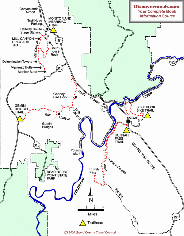
Type:
Dirt Road; Shuttle RequiredDifficulty:
ModerateAttractions:
Gemini Bridges, a pair of natural rock spans; spectacular views of Behind the Rocks; and colorful rock formations.Length:
13.5 milesTrailhead:
On Highway 313 at a point 0.9 mile west of the Mineral Bottom turnoff (12.6 miles west of the Utah 313/US191 junction).Type of Ride:
The Gemini Bridges Trail is well known to local riders for its scenery and long descents. Starting from Utah313, the trail, except for the climb out of Little Canyon, is nearly all downhill back to Highway 191.The first section of the trail is a rapid descent for 3.8 miles along a graded road through pinyon-juniper woodland. just after the road enters a huge open flat, turn right off the main road and go past an abandoned drill site (note the large metal post). Ride under a power line and descend into a wooded area where, after 0.9 mile, you will come to the intersection with the Four Arches Trail.
From the intersection of the Four Arches Trail and the Gemini Bridges Trail, continue to parallel the Bull Canyon system (on your right) until just before the end of the large open area. At this point, which is 0.6 mile from the Four Arches intersection, another trail crosses your route; go right at this intersection and then up over a low sandy hill and descend to the Gemini Bridges. The Gemini Bridges are located at the end of this spur which is about 0.2 mile long.
After viewing the bridges, return to the main trail. The next stretch of the trail winds through a wooded area and is mostly slickrock. After 1.4 miles, you rejoin the road that you left at the d rill pad. Go right and descend into Little Canyon. After 0.8 mile you will come to the intersection with the Bull Canyon Trail. Go left to stay on the Gemini Bridges Trail. Continue the descent into Little Canyon down a steep section of slickrock and loose dirt. At the bottom of the hill is the intersection with the Gold Bar Rim Trail. The Gemini Bridges trail goes left and crosses a large sandy wash. Ahead you will see Gooney Bird Rock. Beyond Gooney Bird Rock, the main trail continues its gradual ascent through Little Canyon. Much of this section is fairly sandy as the road keeps crossing the wash.
Near the head of the canyon, the road leaves the canyon bottom and climbs a fairly steep grade. The road then contours high above Highway 191. At this point, from your narrow perch on the road, you will have a spectacular view over Arches National Park. The road then quickly descends to the railroad tracks and Highway 191.
If you have left a vehicle here, then it is time to begin your shuttle. To avoid highway traffic in Moab Canyon, ride south on U.S. 191 for about 200 yards from the lower Gemini Bridges trailhead, then turn left onto a dirt road. Cross the yellow cattle guard and then follow the road to the right for a scenic ride through Moab Canyon that ends about 1/2 mile North of the Arches National Park entrance road. Some riders prefer to ride back to Moab.
Horsethief
Back to Top of ListThis system of trails gives campers recreational biking near the campground and also connects the BLM’s Horsethief Campground on Hwy 313 to the 7-Up, Mag-7, and Getaway/Great Escape trail systems, eliminating the need to drive to various trailheads to access these other trails.
-
Length:
0.8 miles of beginner singletrack.Difficulty:
Smooth dirt trail with gentle dips and curves. About 30 ft of elevation loss/gain.Type of Ride:
A loop trail just down from the campsites. Connects to campground at 2 places and via a gate to the Rowdy trail south of the fence. -
Length:
8.7 milesDifficulty:
Intermediate; the length of this trail makes it moderately strenuous. 900 ft of climbing throughout its entirety; riders can expect a good descent at the beginning with a meandering climb back to the TH. It’s not a bad idea to bring extra water and plan on this ride taking you a little longer than expected. Rodeo is best ridden clockwise.Type of Ride:
You will encounter sections of slickrock, sand, and dirt. This trail meanders through juniper/pinyon stands as well as open fields. This trail does not offer the vistas that some trails in the Horsethief area have. That being said, if you are looking for a fun, long ride that takes you into remote desert, then Rodeo is for you! -
Length:
0.5 milesDifficulty:
More difficult than Wrangler. Some rocky climbs; more slickrock; steeper hills. About 30 ft of elevation loss/gain.Type of Ride:
A loop accessed from Wrangler or the Chisholm trails. Dirt and slickrock through washes and trees. -
Length:
7.1 milesDifficulty:
Intermediate riders. Slickrock, ledges, dirt; slightly technical. Total climb about 600 feet from the Big Lonely junction to high point. Crosses gas pipeline twice, Mineral Bottom Road and Hwy313. Average grade about 4%.Type of Ride:
This trail connects the Navajo Rocks Trails to the Horsethief campground and with the Mustang Loop & then Getaway and all of Mag 7. Surface mostly sandstone and dirt; terrain Pinyon and Juniper forest. Traverses drainages, sandstone bluffs, narrow ledges, and a wood bridge. -
Length:
3.1 mile loop with and spur to GetawayDifficulty:
Intermediate plus riders; aerobically demanding. Moderately technical. From the connection with Whirwind to a saddle about 290 ft of elevation. Average grade about 6%.Type of Ride:
Surface varies from dirt to slickrock patches. Vegetation is pinyon-juniper. Numerous interesting turns, drops, and climbs over and along ledges and drainages. The run from Getaway to Whirlwind continually loses elevation so can be fast for good riders. -
Length:
2.2-mile loop connecting to 7-Up trail.Difficulty:
Intermediate riders. 230 ft of elevation gain/loss. Average grade 5%Type of Ride:
Trail crosses washes on dirt and rock. Mostly pinyon and juniper forest. Some ledges and mild drops. -
Length:
0.6 mile connector to 7-Up road.Difficulty:
Intermediate; physically challenging going up; fast going down. Slightly technical. Average grade about 7%. 180 ft of elevation difference.Type of Ride:
Rock and dirt; pinyon and juniper; ramps to climb ledges. -
Length:
0.8 mile connector to 7-Up singletrack.Difficulty:
Intermediate; physically challenging going up; fast going down. Slightly technical. Average grade about 6%. 90 ft of elevation difference.Type of Ride:
Rock and dirt; pinyon and juniper; ramps to climb ledges. Descends into a valley then climbs up to a ridge where it connects to 7-Up.
Hurrah Pass
Back to Top of List
-
Type:
Paved Road and Graded Dirt Road; Out and Back Type RideAttractions:
Views of the Colorado River, petroglyphs, scenic canyon.Length:
33 miles round trip from MoabTrailhead:
The junction of Highway 191and Kane Creek Boulevard in Moab.Description:
From the junction of Highway 191 and Kane Creek Boulevard in Moab, follow Kane Creek Boulevard west to its “Y” with Fifth West. Go left. In about 0.5 mile, the road reaches the Colorado River. The pavement ends after 2 miles at the mouth of Kane Creek Canyon. The road initially parallels the stream, then climbs high above it. Stop at the turnout before the road heads down the switchbacks for a view of the canyon and its surrounding ocean of rock. Try to pick out the route of Kane Creek as it meanders toward the Colorado River. From the pass, it is a quick ride down through a pair of steep switchbacks to Kane Creek. Below the switchbacks is a grove of shady cottonwoods and pouring from the wall along the left side of the road a spring. In another mile, the road passes the mouth of Hunter Canyon. Beyond Hunter Canyon, Kane Creek Canyon opens up into a huge amphitheater. The high point ahead is Anticline Overlook. Hurrah Pass is located below and to the right of the point.Follow the road over a low hill by some colorful rock formations to where it crosses Kane Creek (may be dry). Ride straight ahead to the “Y” junction. The Kane Creek Canyon 4-wheel drive trail goes left. Take the right fork to Hurrah Pass. From here, it is nearly all uphill. The road follows one of those improbable routes found only in Canyon Country as it snakes its way up a series of narrow Moenkopi Formation ledges. On the way to the pass, you will be rewarded with spectacular red rock country views.
This ride may be shortened by starting at a point farther along the route such as the entrance to Kane Creek Canyon.
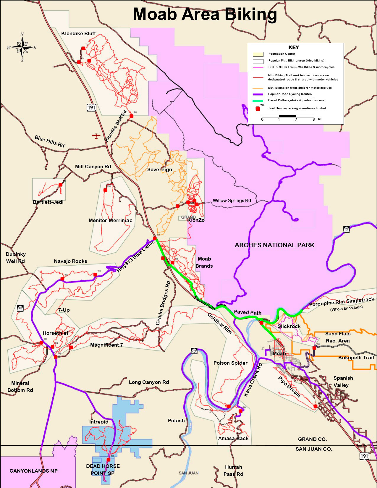
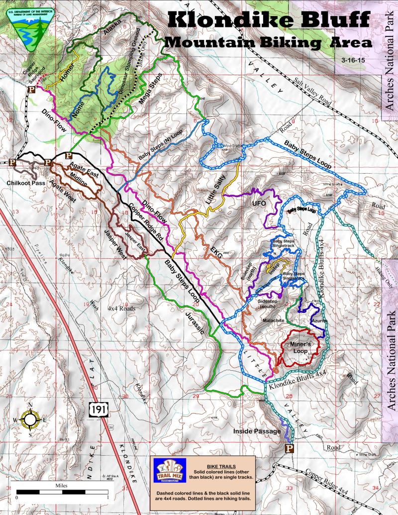
Klondike Bluff Area
Back to Top of ListTrailhead: The junction of Highway 191and Kane Creek Boulevard in Moab.
-
Length:
8.2-miles out & back from Klondike trailhead (14 miles out & back from highway)Difficulty:
Some sections physically challenging (~600 ft climb); technically easy/moderateThe Ride:
The Klondike Bluffs Trail represents a step up in terms of exertion and skills required, but is still enjoyable for fit novice mountain bikers. The route follows a jeep trail across Moab Member slickrock imprinted with fossilized dinosaur tracks. The jeep trail terminates at the boundary of Arches National Park, where a short hike leads to the top of the bluffs and an impressive viewpoint. The Klondike Bluffs Road from Hwy-191 is bumpy but maintained for passenger cars (except when wet) to the trailhead and it’s worth driving to the trailhead and skipping the ride on the dirt road. -
Length:
Ridden from the Highway 191 trailhead, the trail out and back is 20.7 miles. Allow 3 hours for the complete loop. From the Klondike trailhead out and back is 14.9 miles.Difficulty:
Don’t be fooled into thinking that the name of this trail means it is easy. It is the quintessential desert ride with all types of terrain. You will have to climb almost 1700 feet. The first two singletrack sections were specifically designed for mountain bikes and offer some fun, semi-technical riding that will challenge any rider. The last singletrack section back to the valley floor is a fun downhill. PLEASE be considerate of the trail markings, STAY ON THE TRAIL, and keep it single track.The Ride:
At the first intersection beyond the sandy wash and big cottonwood trees, look for the Baby Steps sign pointing left. Ride along through Little Valley (also part of the Copper Ridge Jeep Route), and keep an eye out for the right hand turn that leads to some fun sloping slickrock, and cairns marking the route all the way to the first singletrack section. This is not high speed singletrack, more like tight, semi-technical maneuvering. Keep your speed in check to eliminate blowing out of the corners and creating unsightly, environmentally unfriendly, tracks. At the intersection of more slickrock, go left and look for dinosaur tracks as you peddle to the next singletrack. The trail intersects a jeep road and traverses slickrock until it intersects the Klondike Bluffs Trail. Baby Steps turns to the left and climbs up the hill and over the ridge. This next section, sometimes referred to as The Three Passes, offers some challenging climbing, fast riding, interesting mining sites, and a great downhill! Once back in Little Valley, hang a left that will lead you back past the beginning of the Baby Steps ride. -
Length:
Out and back from the start off of the Dino-Flow trail is 10.6 miles (5.3 mi one-way)Difficulty:
Physically and technically challenging. It was named EKG for 2 reasons – the track on a map and the elevation profile look like EKG charts, and riding either direction will punch up your heart rate. From south to north the climb is ~1100 ft over 2.8 miles and the descent is ~935 ft over 2.5 miles. Average grade about 7%.The Ride:
The trail begins ~1000 feet up the Dino-Flow trail from the Klondike Bluff 4×4 road. At the junction sign turn right and follow the orange painted dashes on the slickrock. The trail entails riding up and down slickrock to cross numerous drainages cut into the sandstone. It is sometimes bumpy, very technical, physically demanding, and incredibly fun. If you decide it is above your comfort level you can bail at 4 places where it intersects other trails. -
Length:
A 1.7 mi bail trail off of the Baby Steps Loop. Connects the Loop to the valley road (Copper Ridge Rd)Difficulty:
The trail is partially on a closed 2-track and partially on slickrock. If you ride up you’ll climb 446 ft (262 ft/mi). Going down is much more enjoyable.The Ride:
From the Baby Steps Loop the trail begins as you finish the climb out of Salt Valley. The beginning 2-track descends to a slickrock trail marked with gold dashes that is more twisty, rough, and steep, before intersecting with the EKG trail. Continue following the gold dashes until reaching the Copper Ridge Rd. It’s a fun, short down grade run. -
Length:
A 3.1-mile trail from Baby Steps Loop to the Copper Ridge Rd.Difficulty:
This trail has a variety of interesting terrain – slickrock, wooded, dirt, and closed 2-track. Riding up from Copper Ridge Rd you will climb 823 ft at a 5% grade(average) challenging the heart and lungs.The Ride:
Either direction (up or down) keeps your attention with swooping curves, slickrock raceways, rock-paved bench cuts, mildly technical ascents, and incredible views of Salt Valley and Eagle Park (Arches NP). Don’t miss this one. -
Length:
1.6 miles connecting the south Baby Steps Loop to Little Salty. Allows riders to choose a shorter (less sandy) loop than the full Baby Steps Loop.Difficulty:
The trail is best suited for fit intermediate to advanced riders because of the turns, climbs and descents. The elevation difference between the highest and lowest point is about 130 feet and the average grade about 6%, but grades through the switchbacks over the passes exceed 15% in places.The Ride:
From the south end this trail shoots down a short slickrock canyon that opens up on a large slickrock pad that you must ride up before starting the steeper climbs over two dirt and rock passes to connect with Little Salty. The “UFO” has landed in the valley between the passes. Take breather in it’s shade, but stay warm for the climb out. -
Length:
A 3.6-mile loop connecting the Mega Steps high ridge to the north end of EKG.Difficulty:
This trail has a variety of interesting terrain – slickrock, wooded, dirt, and closed 2-track. Riding up from Copper Ridge Rd you will climb about 750 ft at a 6% grade(average) challenging the heart and lungs. The traverse across to Mega Steps has some exposure and a climb through some house size rocks.The Ride:
Either direction (up or down) keeps your attention with swooping curves, slickrock raceways, rock-paved bench cuts, mildly technical ascents, and incredible views of Salt Valley and Eagle Park (Arches NP). Don’t miss this one. -
Length:
A 1.9-mile trail from Dino-Flow Loop up to and across Alaska.Difficulty:
Nome requires more technical skill than Alaska to successfully manage some sections of slickrock, located in the horseshoe. If you ride up Mega Steps and the last short section of Alaska to start the Nome ride, the difficulty is slightly moderated because you will be descending the most technical sections instead of climbing. Riding up from Dino-Flow you will climb ~300 vertical ft at a 6% grade(average) before it begins to level out.The Ride:
Either direction is fun with rolling slickrock bumps and mounds and some intricate descents. You can stop to watch riders below quickly negotiating the long Mega Steps descent. -
Length:
About 0.7 miles long connecting Dino-Flow to about the midpoint of Alaska.Difficulty:
Homer is slickrock and dirt, but steeper than Nome or Alaska (7% average grade). Riders with strong hearts will enjoy the climb. Riders on Alaska whose needs require a privy will enjoy the descent to the Copper Ridge Saurapod Trackway parking lot.The Ride:
Either direction (up or down) requires focus because of drops and turns that could surprise the unwary. -
Length:
5.6 miles connecting the parking lot for the Copper Ridge Saurapod trackway with the Klondike Bluff Road. Crosses Mega Steps, Baby Steps Loop twice, Little Salty once, and kisses EKG trail at a drainage crossing.Difficulty:
This trail wanders along the dirt and slickrock between EKG and the Copper Ridge Road. It was designed for lower intermediate riders, but beginners and experts will also enjoy this mellow ride. The elevation difference between the highest and lowest point is only about 140 feet, but either direction will require climbing (and descending) a total of about 500 feet; sort of like a kiddie roller-coaster.The Ride:
If you want to avoid riding on the Copper Ridge Road or if you want to warm up before climbing up Little Salty or Baby Steps Loop, this is the trail to use. From the dino trackway lot to Klondike Rd it traverses dirt rollers, sandstone slopes, numerous dry creeks and several rocky outcrops as it snakes along the contact of the Brushy Basin Shale and the Salt Wash Sandstone. If you find the trail too difficult you can bail out at Mega Steps, Baby Steps North, Little Salty, or Baby Steps South. If you want more technical challenge you can also ride up to EKG at any of these junctions. -
Length:
3 miles including spur to Baby Steps Loop. South end starts off of Copper Ridge Rd. North end starts off of Jasper.Difficulty:
The trail has a few ups and downs, but mostly weaves a track that is at the same elevation throughout. Crossings of the larger washes are often dry sand, so dismounting and walking may be less strenuous. Be ready for a narrow (18-in) rock bridge, maneuvering thru frig-size rocks, and roller-coaster style drain crossings.The Ride:
If you want to access the Agate and Jasper Loops from the south parking area and not ride the Copper Ridge Road this is the trail to use. Or this is a good trail for beginners to up their skill level so the ride back on Dino-Flow is not a disaster. -
Length:
The loop is 1.8 miles and the centerline trail is 0.8 miles.Difficulty:
This loop and the centerline 2-track was designed for beginning singletrack riders. The grades are gentle. The west loop and centerline 2-track are slightly easier than the east loop that follows the crest of a ridge.The Ride:
This is a good trail to get used to riding singletrack. It is wider in the beginning but narrows a bit as it approaches the junction with centerline trail. Ride the centerline back to the start if you need more practice or ascend to the ridge for great views of other riders on Dino-Flow and EKG. -
Length:
The loop is 1.7 miles and the connectors to Copper Ridge Rd are both about 0.3 miles.Difficulty:
This loop is slightly more challenging than the Agate Loop, but still for beginning singletrack riders. The grades are gentle. The west loop is easier than the east loop that follows the crest of a ridge. The south end connector has one short steep ascent that a beginning cyclist might want to walk.The Ride:
This is another good trail to get used to riding singletrack. It is wide on the west side as it flows through gentle rolling hills covered with chert. The trail narrows as it ascends onto the ridge overlooking the Copper Ridge road. A fun ride for beginners would follow the west side of each loop, then return to the start on the Copper Ridge road. -
Length:
0.4 miles from south parking area to the intersection with the Copper Ridge road.Difficulty:
Do not ride if very wet. The Brushy Basin silty-clay is greasy when saturated. This track avoiding much of the sandy road is suited for intermediate riders mainly because of short climbs and maneuvering thru boulders. It goes through a saddle that is about 50-60 ft of climb in either direction.The Ride:
This is a fun little romp through rocky terrain, a couple of washes, and some large boulders that have tumbled down the silty slope from the outcrop at the top of the bluff. The first wash has been bridged with a 1-ft thick x 12-ft long slab of sandstone with steep, fast approaches. -
Length:
1.8 mile loop beginning and ending off of EKGDifficulty:
Intermediate to Advanced. Averaged grade ~ 7%. Climbs about 330 feet before letting you gravitate back to the start.The Ride:
This track is a lot of slickrock, but not as rough as EKG. There are sections of dirt that will be soft when dried out. The south side of the loop has interesting twisty turns thru P-J forest and skirts close to a mining area before turning north to climb more aggressively onto the sandstone ridge, which forms the north side of the loop. Views are inspiring, but this is the norm for the high points of most Klondike trails. -
Length:
1.0 mile loop beginning and ending at the small north parking area. A short spur off of the loop connects to the Agate trail head and parking lot.Difficulty:
Beginner. Averaged grade ~ 4%. Counter-clockwise the trail climbs mildly as it explores the upper reaches of a small drainage. After reaching the top of this drainage you get to coast back down, then choose to go back to the origin of divert over to Agate.The Ride:
This track is mostly dirt on broken mudstone. The track meanders thru a boulder field coming back from the high point, then rolls over a couple of shallow washes before you come to the spur junction that traverses along a low hill to Agate. The cutoff return back to the north parking lot is mildly winding and easy. Parents could conceivably send the kids on the loop while lounging at the parking lot. -
Length:
1.3-mile climb from EKG to Baby Steps (north).Difficulty:
Intermediate to advanced. Grade ~5-8%. Some sections are steeper and require some technical expertise.The Ride:
The track is slickrock with some intermittent dirt sections. Trail climbs up the dip slope of the tilted Morrison Formation layers before intersecting the midpoint of Baby Steps (north). One could call this a shortcut to UFO. -
Length:
0.6 mile climb from Baby Steps up road to Baby Steps (south).Difficulty:
Intermediate to advanced. Grade about 6%. Mostly technical slickrock with some switchbacks.The Ride:
Climbs up the slickrock to the top of a ridge, then descends steeply to Baby Steps ST. -
Length:
0.8-mi connector between Sidestep (north) and Baby Steps (south). Connects to Baby Steps (south) at a 4×4 road.Difficulty:
Intermediate with good heart. From Sidestep (north) the trail descends 100+ ft (9% grade) to a valley floor, then climbs 80 ft to the head of a mini-canyon, then descends 80ft to intersect with Baby Steps (south). Not exactly flat, but fun nevertheless. The reverse climb up is doable even with the steep grades.The Ride:
This track is mostly dirt weaving around large rocks. One short section of bare rock on the initial descent off the ridge. Relatively smooth but some of the turns around boulders are tight with shoulder/head high obstacles. -
Length:
0.8-mi connector between Miner’s Loop and baby Steps (south).Difficulty:
Intermediate to advanced. One or two steep technical spots. Average grade 7%.The Ride:
Very rough rock near Miner’s Loop with tricky ramp down. More dirt near Baby Steps. If you are a paleo-buff there is a petrified log to view about 50 feet off this trail. -
Length:
1.2 mi winding connector between Miner’s Loop and Malachite.Difficulty:
Intermediate to advanced. Climbs are moderate until the final approach to Malachite; then are steep and technical in a few spots. Somewhat easier from north to south.The Ride:
Over ridge and swale and ledge and arroyo. Never bored; always alert. A fun little trek in either direction
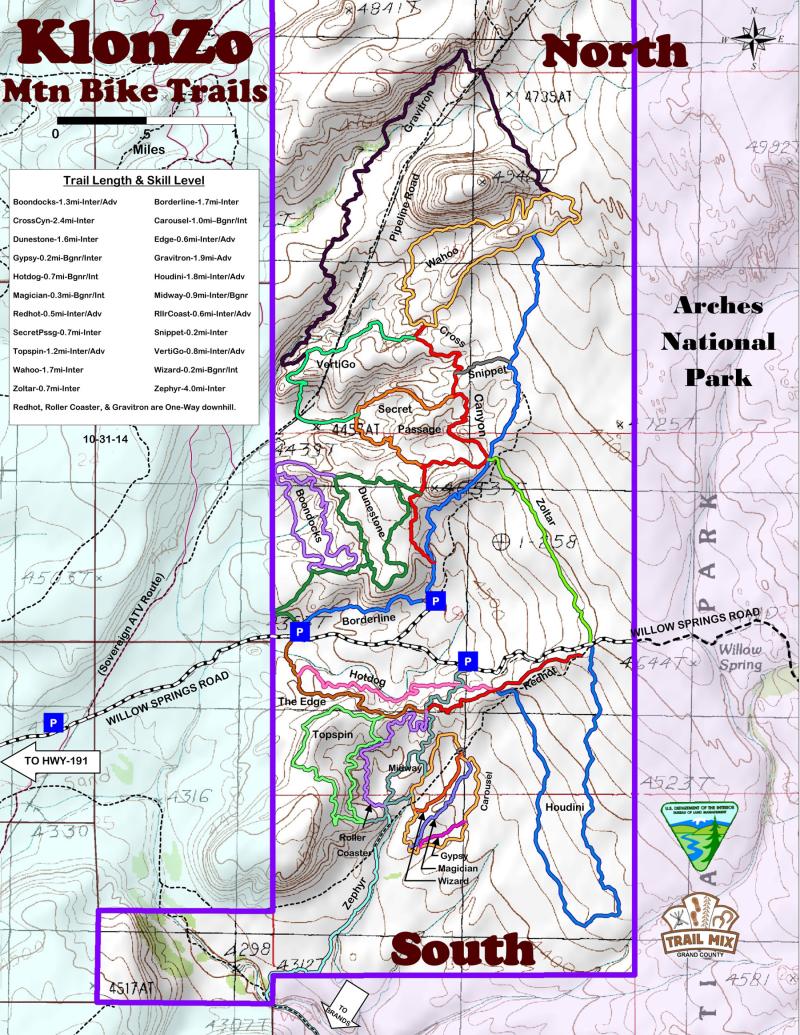
Klonzo
Back to Top of ListThe trailhead for the Klonzo Trails is on the Willow Springs Road approximately 12 miles north of Moab. This trail system currently has 7 trails mostly for intermediate skill level. The trails are within a Mountain Biking Focus Area designated in the BLM’s 2008 Resource Management Plan.
-
Length:
1.7 milesDifficulty:
Intermediate riding skills recommended. From Parking Area A to the junction with the Wahoo trail the trail ascends about 476 ft with an average grade of 6%.Type of Ride:
Primarily smooth red dirt single track for ~1.3 mi, then mildly technical, broken slickrock to the junction with Wahoo trail. -
Length:
1.6 milesDifficulty:
Counter-clockwise riding direction suggested. Intermediate riding skills recommended. Some technical ability needed. From the lowest point of the trail, junction with Cross Canyon trail, the Wahoo trail the trail ascends about 325 ft with an average grade of 7%.Type of Ride:
Trail follows the contact between sandstone and red siltstone as it climbs to the highest point in the Klonzo trail system. The descent into a valley between two buttes is fast and requires technical maneuvering between large boulders that have rolled into the gulch from the highest butte. The loop is connected after crossing a low red ridge and descending to the junction with Cross Canyon. -
Length:
1.3 milesDifficulty:
Intermediate riding skills recommended. Trail starts near Parking Area B and climbs about 260 ft with an average grade of 6% as it crosses several ravines eroded into the red Tidwell Formation and traverses a rocky bench.Type of Ride:
Primarily smooth rolling red dirt single track. The trail serves as a connection between Wahoo, Borderline, Secret Passage, and Dunestone trails. -
Length:
0.7 milesDifficulty:
Intermediate riding skills recommended. From the north end the trail descends about 150 ft with an average grade of 6%. The ~90-ft climb back to Cross Canyon includes a couple of short ascents with a grade of 15%+.Type of Ride:
Primarily smooth, rolling red dirt single track connected to Cross Canyon trail, that takes you down into a hidden valley then back out through a narrow tributary drainage. -
Length:
0.2 milesDifficulty:
Intermediate riding skills recommended. Ascends ~50 ft from Cross Canyon trail to the Borderline trail. Average grade of 5%.Type of Ride:
Connects Cross Canyon to Borderline via a faint abandoned roadway. Some red dirt and some rocky outcrops. -
Length:
1.6 milesDifficulty:
Intermediate riding skills recommended. Technical maneuvering. About 300 ft of elevation change with an average grade of 6%.Type of Ride:
Primarily bumpy and technical slickrock single track on a mesa top, formed by the Salt Wash Member of the Morrison Formation. Great views along the trail when near the mesa edge. Direct access from Parking Area A, or from Parking Area B via the Cross Canyon trail. -
Length:
1.2 milesDifficulty:
Intermediate riding skills recommended. Rolling red dirt with a short steep technical slickrock section when climbing up to Dunestone. Average grade 6%Type of Ride:
Mostly smooth red dirt single track in a low rolling hill area below the Dunestone trail. Boondocks can only be accessed from Dunestone at each end. -
Length:
0.6 milesDifficulty:
Intermediate riding skills recommended. Narrow with some tight turns and peddle catcher rocks. Climbs about 80 ft from Parking A to the ridge top where it meets with Midway, Roller Coaster, and the end of Red Hot.Type of Ride:
Red dirt and limestone outcrops. Mildly technical because of narrowness and turns. Main access to Topspin. -
Length:
0.7 milesDifficulty:
Mostly red dirt singletrack. Easiest ridden from Red Hot to The Edge because it descends about 100 ft. Riding up the grade is also fairly easy. Intermediate riding skills help with the swooping wash crossings.Type of Ride:
Generally fast smooth dirt, but slow for turns that follow contours and dips where washes are crossed. Beginners can improve their skills by riding down from Midway then to the Willow Springs Rd on The Edge, then back up the road to the Midway parking area. -
Length:
1.2 milesDifficulty:
Intermediate riding skills necessary because of turns through boulders and the moderate climbs. Advanced skills help with a few steeper climbs and off camber boulder crossings. Trail can be accessed from The Edge trail or the south end of the Midway trail where it connects at Big Joe Bend.Type of Ride:
Best views of the area from the high line above Big Joe Bend. Lots of ticklish turns through rock strewn wash areas and down steep slickrock slabs. -
Length:
0.9 milesDifficulty:
Intermediate riders will find this access trail fast and fun, and beginners can carefully negotiate the gentle red dirt curves to improve their confidence and end up at the easier trails on the slickrock (Carousel, Wizard, Magician & Gypsy). From the parking area off of Willow Springs Rd the trail climbs about 20 ft to the red ridge top and then descends to the multiple slickrock tongues about 70 ft below.Type of Ride:
Primarily smooth, rolling red dirt single tracks. Includes 2 access spurs, the first aligned between 2 very eroded dino track ways. Stop at the info kiosk and learn about the dinos that walked here 150 million years ago. -
Length:
0.6 milesDifficulty:
Intermediate riding skills recommended. Some ups and downs, but nothing strenuous. Starts and end at about the same altitudeType of Ride:
Crosses the slickrock between the Borderline/Cross Canyon junction and the Willow Springs Rd where Houdini starts with only minor change in altitude. Somewhat rough but fun slickrock trail for intermediate riders. Easy access to the beginning of Red Hot trail. -
Length:
1.8 milesDifficulty:
Intermediate to advanced riding skills recommended. Technical maneuvering on rough sandstone and sand patches. Descends about 160 ft then climbs 70 ft to meet Red Hot and Hotdog trails at the crest of the red ridge.Type of Ride:
Primarily bumpy and technical slickrock single track. Short steep climbs and descents mixed with sand patches makes you work for the views of this remote part of Arches NP. Please remain on the designated track. Free riding is not sanctioned. -
Length:
0.5 milesDifficulty:
One-Way downhill trail. Intermediate to advanced riding skills recommended depending on your speed. Rolling red dirt with steep but smooth descents and rollable bumps and small ledges. Descends 120 ft in about 0.4 mi.Type of Ride:
All smooth red dirt single track. Roll the bumps and ledges on the 1st trip to determine your most comfortable speed on the 2nd trip. -
Length:
0.6 milesDifficulty:
One-Way downhill trail similar to Red Hot. Intermediate to advanced riding skills recommended depending on your speed. Rolling red dirt with steep but smooth descents, rollable bumps, & banked turns. Descends about 100 ft in about 0.4 mi.Type of Ride:
Primarily smooth red dirt single track. Similar to Red Hot, but more severe. -
Length:
1.0 milesDifficulty:
Counter-clockwise riding direction suggested around this loop. You will lose, then gain 60 ft of elevation. Fit beginners and intermediate riders can easily manage this loop.Type of Ride:
Alternates between slickrock and red dirt. Slickrock mostly, but not always, smooth. -
Length:
0.2 milesDifficulty:
Good practice run for beginners. Loses about 40 ft of elevation on downhill run.Type of Ride:
Primarily smooth white slickrock. Connects to Carousel at each end. Return to beginning on any of the other inner loop trails. -
Length:
0.3 milesDifficulty:
Another run for beginners. Stretches of red dirt between smooth white slickrock. Loses about 40 ft of elevation on downhill run.Type of Ride:
About 100 yds of red dirt trail at lower end that turns to slickrock at the parking area section. Twists and turns down a shallow wash. -
Length:
0.2 milesDifficulty:
Fun and easy. All on smooth sandstone that slaloms down the wash. Easy climb back up.Type of Ride:
Smooth white sandstone naturally banked for fun run. -
Length:
1.9 milesDifficulty:
One-way trail from Wahoo to the mid point of VertiGo (1.7 mi). Advanced riding skills recommended. Technical, fast, narrow, steep chutes. You will lose about 300 ft of elevation before starting the short climb out of the canyon to connect with VertiGo. Average grade about 9%. Highest elevation about 4820 ft; lowest elevation about 4510 ft.Type of Ride:
Fast downhill run through rock-armored wash crossings, slickrock, shock-depressing red dirt coasters, and narrow steep-sided bench cuts. -
Length:
0.8 milesDifficulty:
Intermediate/Advanced riding skills recommended. Very narrow side-slope singletrack; tight turns through large shoulder rubbing boulders. Average grade about 10%. Highest elevation about 4620 ft; lowest elevation about 4460 ft.Type of Ride:
Rolling red dirt singletrack in character with other intermediate KlonZo trails, but adding a trundle around a rock ridge on a very narrow steep-sided bench cut, ending with a corkscrew like descent through dozer size boulders. Either direction ends in a climb back to Cross Canyon or Secret Passage. -
Length:
4.0 miles (0.8 mi singletrack; 3.2 mi jeep roadDifficulty:
Road is mostly smooth and suitable for beginners; singletrack best for advanced beginners. Average grade about 10%, but you don’t notice. Highest elevation about 4520 ft; lowest elevation about 4290 ft.Type of Ride:
Singletrack starts off the south end of Midway trail and crosses a flat sage covered bench about 30 ft above the Courthouse Wash floodplain. After crossing an arroyo bridge and sliding into the sandy wash bottom of Courthouse you will ride thru the gate marking the Arches NP boundary. The 2-track road winds its way thru the park on a slickrock bench overlooking the canyons of Courthouse then Sevenmile Washes. Desolate feeling with astounding views across the park . Stay on the road. The 2nd gate takes you out of the park and into the MOAB Brands Mtn. Biking Area. Road continues along the same bench, crosses the sandy bottom of Sevenmile, and connects to the north end of the Bar-M Loop. Several trails will get you to the Brands parking area.
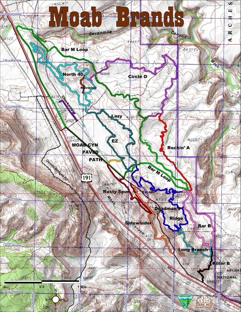
MOAB Brands Focus Area
Back to Top of ListTrailhead: Take U.S. 191 North about 8 miles to the Bar-M Chuckwagon, turn right to enter the Bar-M private parking lot. Park at the South end.
-
Length:
7.9 milesDifficulty:
Nontechnical but somewhat physical. Total climb is 625 feet in either direction. Some steep roller coaster hills to climb at the north end. Average grade is about 3%.Type of Ride:
A mellow family ride on a dirt road with rocky sections. Shared motorized. From the parking lot ride West to the paved path, then south towards Moab, then turn left in 1.2 miles following the directional signs. At the “Merge” turn left and head back north to complete the Bar-M Loop. At the “Merge” you will encounter trailheads for two other trails. Rockin’A and Bar-B. -
Length:
0.6 milesDifficulty:
Easy flat connection to north end of Rusty Spur. Pipeline road is hard packed.Type of Ride:
Flat little zip thru the sage and black brush. Don’t run into a cow… -
Length:
1.5 milesDifficulty:
Easy loop with gentle grades. Two cattle guards to power up and over. Includes about 150 feet of climb in either direction. Average grade is about 3%.Type of Ride:
A somewhat smooth mellow ride on dirt and rock. The trail begins and ends at 3 points off the Moab Canyon paved path. The view point at the south end of the loop offers great views of Deadman’s Curve on the old highway grade (now the Moab Canyon Paved Path). -
Length:
0.4 miles – OneWayDifficulty:
A smooth flowing downhill slalom. Beginners can do it slowly. Experts can fly down it. Average grade about 7%.Type of Ride:
Starts from the east leg of North 40; ends on the east leg of North 40. Mostly red dirt surface with banked turns. Some rocky surfaces crossing washes. -
Length:
0.4 milesDifficulty:
Easy with gentle grades. Dirt singletrack and 2-track road. Average grade about 2%.Type of Ride:
The trail begins at the parking area at 2 points and ends at the Bar-M Chuckwagon. Surfaces will be soft when dry. -
Length:
1.5 milesDifficulty:
Moderately easy with a few more difficult turns and climbs. You will have to climb more than 200 feet in either direction through the Lazy-EZ loop. Average grade is about 3%.Type of Ride:
Enter the Lazy-EZ loop a short distance up a road from the BLM parking lot. Turn right at the Lazy-EZ sign until you reach the junction. The recommended riding direction is counter-clockwise starting with EZ and connecting to Lazy. This loop is fun, fast, with a few surprises. Lazy starts with some bumpy climbs on rocks and then ends with a swoopy, flowy descent back to the Lazy-EZ junction. -
Length:
1.25 milesDifficulty:
Moderately easy with a few interesting turns into hidden valleys and through drainages. A few technical moves through sandstone ridges and boulders keeps your attention. You will have to climb more than 200 feet in either direction through the Lazy-EZ loop. Average grade is about 3%.Type of Ride:
Enter the Lazy-EZ loop a short distance up a road from the BLM parking lot. Turn right at the Lazy-EZ sign until you reach the junction. To the right the EZ trail snakes along the edge of a low sandstone escarpment through drainages and over a wooden bridge. It flows into and out of two erosional breaks in the escarpment to briefly divert your attention away from the open field on your right. It ends through a narrow passage between boulders at the Bar-M Loop. -
Length:
0.2 miles milesDifficulty:
Easy ride connecting EZ trail and Rusty Spur. Good escape for beginners who feel EZ is too rough.Type of Ride:
A mellow, sometimes rutted ride on an old dirt road. Cow pies may be the only obstacle. -
Length:
4.0 milesDifficulty:
This is a longer ride that starts easy, but becomes more challenging. You will climb almost 600 feet either direction you ride, but riding counterclockwise offers the lower uphill grades. The loop can be shortened by about a mile by turning around at the crossover point at the pipeline road. Average grade about 5%.Type of Ride:
Enter the loop across from the entrance to Lazy-EZ (drill pipe), a short ride on a road going east out of the BLM parking lot. The dirt trail will slowly take you up to a high point, thru giant sandstone boulders perched on a ridge, then down and up and down and up until you weave your way to the pipeline road. Turning south on this road will return you to the parking area. Choosing to continue and you will ascend a long slickrock bench and dodge through outcrops before looping back through a rock ridge (narrow passage) to an old campground. Here you can bailout at the road that takes you back to Bar-M loop, or continue the North 40 adventure down a curvy slope, across the pipeline again, then up and onward to the point where you began. -
Length:
2.9 miles (3.1 miles if connecting to North 40)Difficulty:
Beginning intermediate ride all on slickrock. The total climb will be about 300 feet either direction. Average grade about 4%. Connector between Circle O and North 40 is an easy dirt singletrack.Type of Ride:
Slickrock, with many dips and turns. Ride the line that marks the trail to protect plants and soil! Circle O connects to Rockin’A. To reach the trailhead off of the Bar-M Loop, orient yourself on the maps provided and follow the signs. To reach North 40 from the north end of Circle O, ride across the Bar-M loop (road) onto the O to 40 connector. -
Length:
1.6 milesDifficulty:
Another slickrock ride, but bumpier than Circle O. Beginning intermediate skill level. Average grade is about 3%.Type of Ride:
Slickrock with a fun bumpy ride! Stay on the trail and watch for quick turns! Please protect the native soil and plants. Rockin’A trailhead is across from Bar B and connects to Circle O. -
Length:
2.2 milesDifficulty:
Intermediate with one advanced section. Total climb more than 300 ft. Average grade 5%.Type of Ride:
Singletrack ride that goes over hill and dale on slickrock and some closed dirt road. Bar-B Loop trailhead begins at the “Merge” at the southern end of the Bar-M Loop, across from the Rockin’ A trail. Two spur trails connect to Deadman’s Ridge. Killer-B and Long Branch trails connect with Bar-B at its southern end, where it turns back toward the Merge on an old road (not open to motorized vehicles). -
Length:
3.1 milesDifficulty:
More suited for intermediate to advanced riders in excellent physical condition. Numerous ascents and descents over broken and bumpy sandstone. Total climb is 600 to 700 feet. Average grade is about 8%.Type of Ride:
Rocky ridges and valleys with numerous technical turns on steep ascents. Enter the trail by riding Lazy to the trailhead or riding Bar-M loop south (paved path), then left on dirt road to the junction with Deadman’s Ridge. There are 2 spur trails where one can choose to go to Bar-B, and a third intersection with the Long Branch trail at the south end of the Deadman’s Ridge trail. Continuing on Deadman’s leads down a slope demanding your utmost attention and ends at the Moab Canyon paved path at Deadman’s Curve. Return to the parking area by riding north on the paved path or turn left (south) to return to Moab. -
Length:
0.2 milesDifficulty:
Intermediate. Allows an escape from Deadman’s Ridge before the ascent. Leads to the paved path and one connector to Sidewinder.Type of Ride:
All downhill from Deadman’s to the paved path. A couple of wash crossings to maneuver through. -
Length:
1 mileDifficulty:
This trail is a short, more difficult version of Deadman’s Ridge. Either direction you will climb more than 200 feet in this 1-mile section. Average grade is about 8%.Type of Ride:
Start the trail at the south end of Deadman’s Ridge or at the south end of the Bar-B Loop. From Deadman’s the trail dives thru a boulder strewn slope then immediately climbs thru a slickrock valley into a maze of broken sandstone ridges to wind its way toward its meeting place with Bar-B and Killer-B. This trail demands for your peak performance. Return via Bar-B singletrack, Bar-B return road, or via Killer-B to Moab. -
Length:
0.7 milesDifficulty:
This trail is for advanced to expert riders. You will descend almost 500 feet in less than 3/4 mile. Average grade about 13%.Type of Ride:
There are two routes that lead down to the Moab Canyon paved path. The original route is narrow with cliff edges, loose soil, tight turns and steps! It is more suited for hiking than biking. A biking route now traverses the steep rocky slope facing the highway and has 3 switchbacks, but the grades are easier to ride than the steps. Use the trail as a connection to the Old Highway route. Trail begins at the southern end of the Bar B Loop trail. Follow the dirt road downhill 1/4 mile then turn right at the sign onto singletrack. Watch for hikers coming up the trail. The hiker-biker junction is at the top of the bluff overlooking the Highway and the Paved Path. -
Length:
1.5 miles including the connectors to Rusty Spur and the Paved PathDifficulty:
The trail is suited for intermediate riders with some technical skill. Average grade about 8%, but on short stretches of the 300 ft of descent, grades can exceed 25%. The cattle guard crossing should be walked if you are not a precise rider.Type of Ride:
From north to south the trail winds along the west side of the paved path then quickly descends into the canyon below Deadman’s Curve. It then crosses the wash and climbs a wide slickrock ramp, over a hog back and across to a steep narrow side-sloping ribbon into yet another drainage. There is then another climb, another drain, and a final bench cut and run-out to extrude you out onto the pavement. If you think that was fun and easy turn around and try it going uphill.
Monitor & Merrimac Trail
Back to Top of List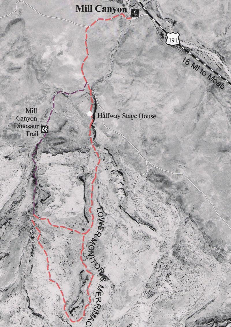
-
Trailhead:
Mill Canyon Trailhead, 16 miles north of MoabDifficulty:
Physically moderate, technically easierTrail Surface:
30% graded road, 20% 4WD road, 50% slickrockLength:
7.5-mile lollipopTrail Surface:
30% graded road, 20% 4WD road, 50% slickrockElevation @ Trailhead:
4500′Highest Elevation:
4950′Elevation Gain:
550′Season:
Ideal in spring, fall and winter; extreme midday heat in July and AugustDirections:
Follow Hwy 191 north from Moab 16 miles and take a left on the Mill Canyon Rd. Park at the trailhead on your right. Ride half of a mile and take a left where indicated. Stay left at the first intersection and take the first sandy right.Description:
This is the best slickrock playground (stay on the rock!) in Moab for novice mountain bikers – less intimidating than Bartlett Wash or the Slickrock Trail. Sandy sections will hopefully be rerouted in the near future. It’s easy to confuse this loop with the Monitor & Merrimac Jeep Trail, which is mostly beach sand and heavily used by vehicles. The historic Halfway Stage house and the fossil quarry at the Mill Canyon Dinosaur Trail can both be visited on this ride.
Navajo Rocks
Back to Top of List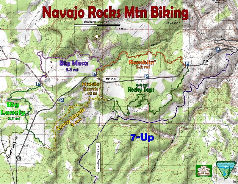
-
Length:
About 4.4 miles longDifficulty:
Solid intermediate ride with one tricky approach to a steep climb, and one mentally challenging off-camber traverse. Average grade about 6% with short climbs exceeding 15%. The high point is about 5300 feet; the low point about 5000 feetThe Ride:
If riding as a continuation of the Ramblin’-Rocky Tops loop (clockwise) the trail starts at SR-313 and proceeds southwesterly along the Navajo Ss outcrop that forms the north edge of the Sevenmile(S. Fork) canyon. The trail dips a swerves through Navajo Ss outcrops, sometimes thinly covered with dirt and sand. The variety requires focus until after you cross over the lip of a 150-ft pour off. A smooth 2-track (open-road) then allows a more leisurely jaunt toward two distant stone mesas that you must ascend and cross. The route of this crossing is convoluted enough to keep your attention, and includes a seemingly impossible traverse across an off-camber slope of rough sandstone at the foot of a 50-foot vertical wall. That done the trail climbs and turns back on itself to finally allow you access to the top of the large mesa where you welcome the smooth flowing surface with a very comforting coefficient of friction. Now enjoy the ride through pinyons on stone (some dirt) as you make your way to the west side of this rocky-top plateau; then savor the descent through 4 turns to the outcrop base with the end of the loop in sight. This trail is equally interesting riding in the opposite direction. -
Length:
About 3.2 miles longDifficulty:
Intermediate ride with aerobic climbs, heart-skipping descents, and moderately smooth cross-country travel. Average grade about 6% with 5 or 6 stretches exceeding 15%. The highest point is about 5200 feet and the lowest point is about 4950 feet.The Ride:
Ride the Ramblin’-Rocky Top loop clockwise by starting at the Wipe-Out-Hill parking area off of SR-313. Ramblin’ climbs for a short distance then descends and crosses the WOH spur road and hugs the north edge of Sevenmile (N. Fork) for a half mile. Then you plunge over the edge via a surprisingly smooth ramp into the canyon where you will adroitly snake your way between treed crypto islands before crossing another smooth hidden sandstone dip onto a dirt track ending at the wash crossing. Now it’s up gently to another smooth red stone shoulder, cross a 4×4 road, then plunge into and out of the main N. Fork crossing. From here the traverse along the south side of Sevenmile is undulating between dirt track and sandstone outcrop, sometimes climbing, sometimes descending and always turning and twisting through the maze of rock and treed slopes until after a steep slickrock climb, emerging onto the 313 crossing to Rocky Tops trail. This trail is equally interesting riding in the opposite direction. -
Length:
About 3.0 miles longDifficulty:
Intermediate ride along the toe of Big Mesa, then cross-country travel over sandstone and down a side slope to Big Lonely. Average grade about 3%. The beginning and ending stretches slightly steeper, so about equal in difficulty going either direction. The highest point is about 5400 feet and the lowest point is about 5280 feet.The Ride:
Starting at the Wipe-Out Hill parking on the Ramblin’ trail. Less than a quarter mile turn left onto Big Mesa Trail. Climb up to the top of a sandstone bench and traverse around to cross over the North Fork of Sevenmile Wash. From here on your right is the cliff wall of Big Mesa. Stop on the bridge, turn around and look up at the top of the cliff wall and you will see Skywalk arch. The trail continues along the cliff, then follows slightly rough slickrock outcrop around a point then back south toward the Big Lonely. -
Length:
About 3.0 miles longDifficulty:
Intermediate ride over a sandstone ridge, then cross-country travel on dirt with intermittent sandstone outcrops. Average grade about 3%. Several short stretches exceed 15% and one 30-ft long slickrock climb is about 100% (45 deg). The highest point is about 5600 feet and the lowest point is about 5350 feet.The Ride:
From Dubinky Well road the route takes you up onto a Navajo Ss ridge with great west views, then climbs more slowly as you ride over another smaller sandstone knoll, before crossing SR-313 and dodging through junipers and black brush to the south end of the Coney Islands trail. -
Length:
About 0.5 miles longDifficulty:
Short Intermediate ride minor technical. Average grade about 3% with a one or two short steeper descents or climbs. The highest point is about 5660 feet and the lowest point is about 5230 feet.The Ride:
A quick ride over sandstone between the Ramblin’ trail and the Coney Island trail. Makes it easy to ride the separate east or west loops of Navajo Rocks or to do the whole loop as a figure eight.
Sand Flats Recreation Area
Back to Top of List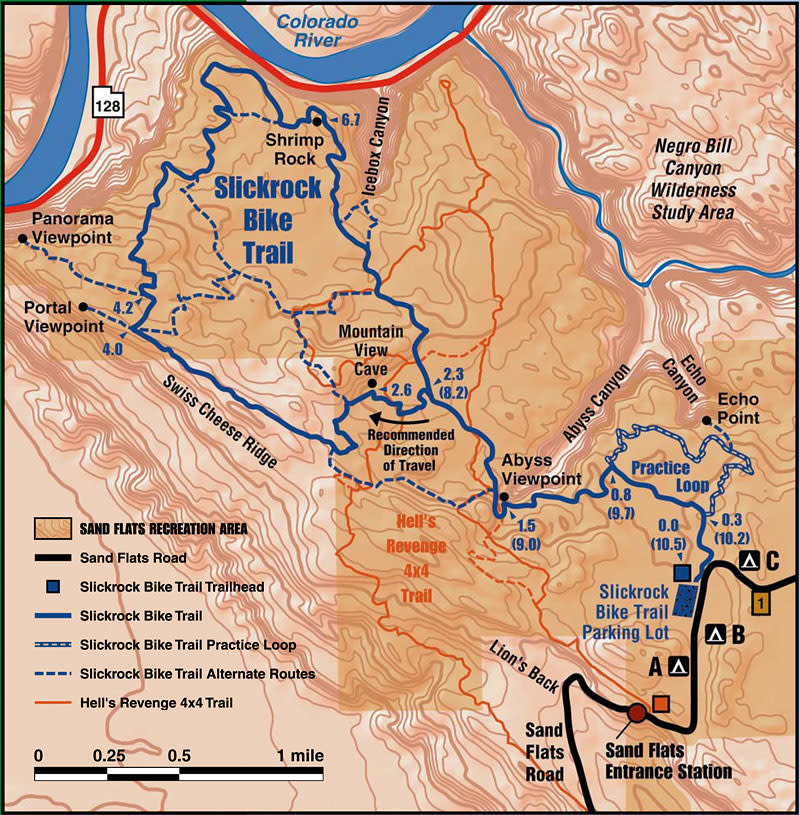
-
Length:
10.5 miles (main loop); 2.2 miles (practice loop)Difficulty:
Physically difficult, technically difficult. The complete trip along the main trail from the trailhead out to the loop, around the loop, and back to the trailhead covers a distance of 10.5 miles, not counting any spur routes. The trail constantly changes elevation as it crosses a series of Navajo sandstone domes and fins. Because of the numerous steep ascents, many riders need 3 or 4 hours to complete the trail. Several portions of the main trail are marked with yellow dashes where the trail follows narrow ledges or abrupt drop-offs. Riders are cautioned to be especially careful at these locations and anywhere else the trail approaches a cliff, changes grade, or crosses rutted rock.Type of Ride:
The Slickrock Bike Trail was established in 1969 for motorcycle riding and is open to both motorcycles and mountain bikes. It is closed to all 4-wheeled vehicles. The routes of both the main trail and the practice loop are indicated by painted white dashes. Trail intersections are also painted on the rock. Short sections of sand provide a change from the rock. There are tough spots that may, for many, require walking bikes. The trail is located on a heavily eroded sandstone plateau between Moab Valley and the Colorado River in the Sand Flats Recreation Area. To reach the trailhead from Moab, drive 2.3 miles east on Sand Flats Road from the intersection of Mill Creek Drive and the Sand Flats Road. The Slickrock Trail is normally used from March through November although the spring and fall months are the most popular. Snow usually covers the trail from late December through February. Early morning and evening rides are best during the summer when mid-day temperatures can exceed 100 degrees Fahrenheit. Trailhead facilities include a parking area, rest rooms, information boards, picnic tables and a dumpster. There is no drinking water in the area. The Sand Flats Recreation Area is managed through a unique partnership between Grand County and the Bureau of Land Management. A day use fee is charged. -
Length:
From the trailhead, Porcupine Rim Trail is 14.4 miles to Highway 128 or 20.4 miles to Moab. If ridden as a loop, the entire ride is 30.8 miles with an elevation gain of 3,000 feet. Shuttle services in Moab can provide transportation to the trailhead.Difficulty:
The difficulty rating for bikes is a 4 (difficult), on a scale of 1 to 4. It includes a 3-mile, 900-foot ascent from the trailhead to Porcupine Rim and then an 11-mile, 2,800-foot descent to the Colorado River. One of the great attractions of the trail is the stunning view it offers of Castle Valley from the top of the Rim.Type of Ride:
The trail is marked with brown flexible posts, cairns and occasional symbols painted on rock. Normal riding season for the trail is from late March through late October. Due to the high elevation of the rim, snow, rain or cold temperatures may occur during early spring and late fall. The single-track section is extremely technical and exposed in many places. This section may require dismounting and walking. Trailhead facilities include an information board, vault toilet, trail register and limited parking (if the parking area is full, park along the north side of the main road, facing Moab). The water in the stock tanks at the trailhead is not potable. There are numerous spur routes off the main trail, most of which are indicated on the main map. Many of these are dead-ends. Follow the main trail on the map to avoid getting lost. -
Length:
1.8 miles staying along the rimDifficulty:
Technically challenging. Trail splits into a rim ride section and the Notch section. The Notch is for experts only. The rim ride section has an entry drop that is difficult. Most hoof it over these obstacles. Average grade is 11%.Type of Ride:
5th ride of the Whole Enchilada. Officially starts at the small cattle guard on the boundary between US Forest land and Bureau of Land Management land. The trail has numerous drops and slickrock to negotiate. -
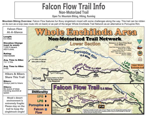
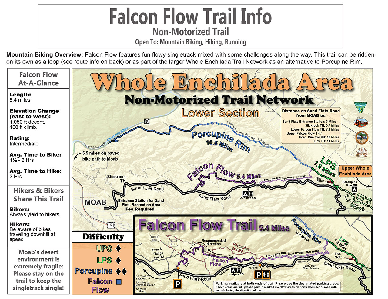
Length:
5.4 miles with 1,050 foot decent and 400 foot climb (from east to west). Average time to bike this trail is 1.5 – 2 hours.Difficulty:
IntermediateType of Ride:
Falcon Flow features fun flowy singletrack mixed with some challenges along the way. This trail can be ridden on its own as a loop or as part of the larger Whole Enchilada Trail Network as an alternative to Porcupine Rim.
Sovereign Single Track
Back to Top of List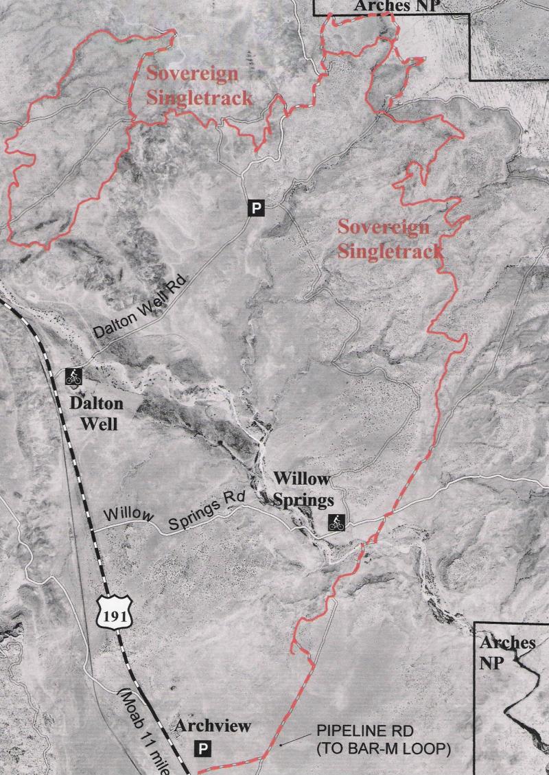
-
Trailheads:
Willow Springs Rd (most popular), Dalton Wells Rd, Archview Campground (primarily OHVs) 11-13 miles north of Moab on Hwy 191.Difficulty:
Physically challenging, technically moderate/difficultTrail Surface:
80% singletrack (with long rocky and technical as well slickrock sections)Length:
16 miles point-to-point, several out & back and loop optionsLowest Elevation:
4350’ @ Willow Springs RoadHighest Elevation:
4950’ @ top of Garden MesaSeason:
Ideal in spring or fall; extreme midday heat in July and August. Avoid when raining or snowing.Directions to Willow Springs Trailhead:
Follow Hwy 191 north 11 miles to Willow Springs Rd and turn right. Proceed 2.5 miles to trailhead. Note: road can be sandy and difficult for low clearance vehicles.Directions to Dalton Wells Trailhead:
Follow Hwy 191 north to Dalton Wells Rd and turn right. Take left fork and park. Close the gate behind you and ride. Road comes to a fork at 1.5 miles and a trailhead kiosk. The left fork access singletrack to Garden Mesa (cairn marks the entrance a quarter-mile up the road on your left); the right fork intersects the singletrack in 1.25 miles).Description:
Of the many miles of ATV, jeep, and motorcycle trail in the Sovereign Trail System, the Sovereign Singletrack is the best suited to mountain bikes (along with roads marked on the map). Shorter out-and-back rides can be started from trailheads at Willow Springs (a popular option) or Dalton Wells Rd. The singletrack climbs and descends ridges of the Morrison Formation; rocky, technical sections are interspersed with smooth and flowing trail. Expect to encounter motorcycles. Bring a map as entrances to the singletrack at road intersections have been camouflaged to discourage ATV use. Thank Ride with Respect for developing this multi-use trail system. *
Spanish Valley & Sand Flats Recreation Area
Back to Top of List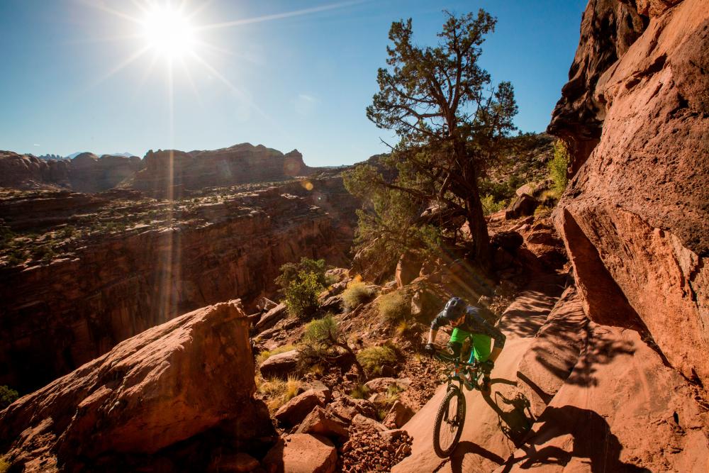
-
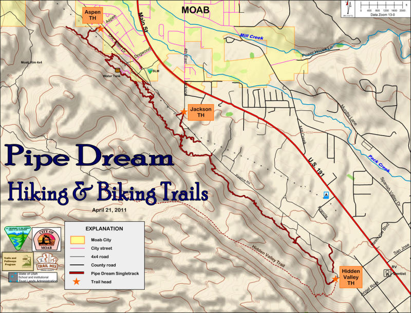
Length:
4.8 mile (one way); another 3.2 miles of connectors and access routes.Difficulty:
Advanced intermediate and advanced riders; aerobically and technically challenging. The profile looks like the teeth on a saw blade. Total climb if starting at Hidden Valley TH is 1650 feet. Total climb if starting at Aspen St TH is 2160 feet. Average grade is about 15%.Type of Ride:
Start the trail at the south end at the Hidden Valley Trailhead. Access off of Hwy-191 at Angel Rock Rd. Follow the sign directions to the trailhead. The trail surface features dirt, rock armoring, shale bench cuts, and black brush slopes. Hills are steep and turns must be precise. This is a favorite with local riders. -
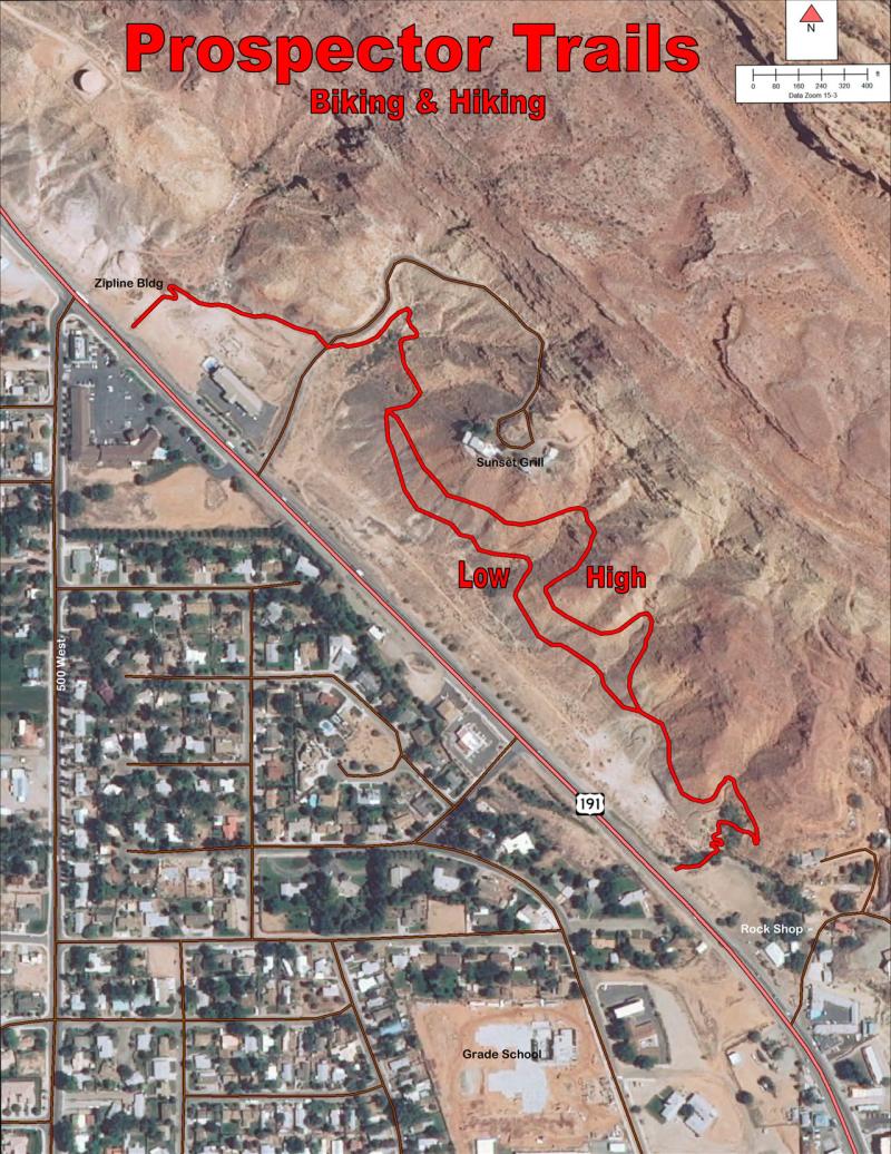
Length:
1.4 miles of trail; includes the upper and lower sections. All on private property.Difficulty:
Mostly for intermediate and advanced intermediate riders, not because of technical difficulty, but for psychological difficulty. The lower section is easier than the upper section. The trails are narrow and built into a steep broken, rubbly sandstone slope. Falling down this slope would be painful. Because of the occasional steep grade and sandy surface on the upper trail, it is aerobically and technically challenging. You might even have to walk a section or two. The steepest grade on the upper trail going north exceeds 20%.Type of Ride:
At the south end the trail starts at the Rock Shop. At the north end the trail starts at the Zipline and connects to the paved path to the river. Access is off of Hwy-191 just north of the Rock Shop or down from the Zipline HQ. Map signs at each trailhead gives you details. The trail surface is sand on rock, dirt, and some slickrock.
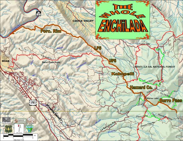
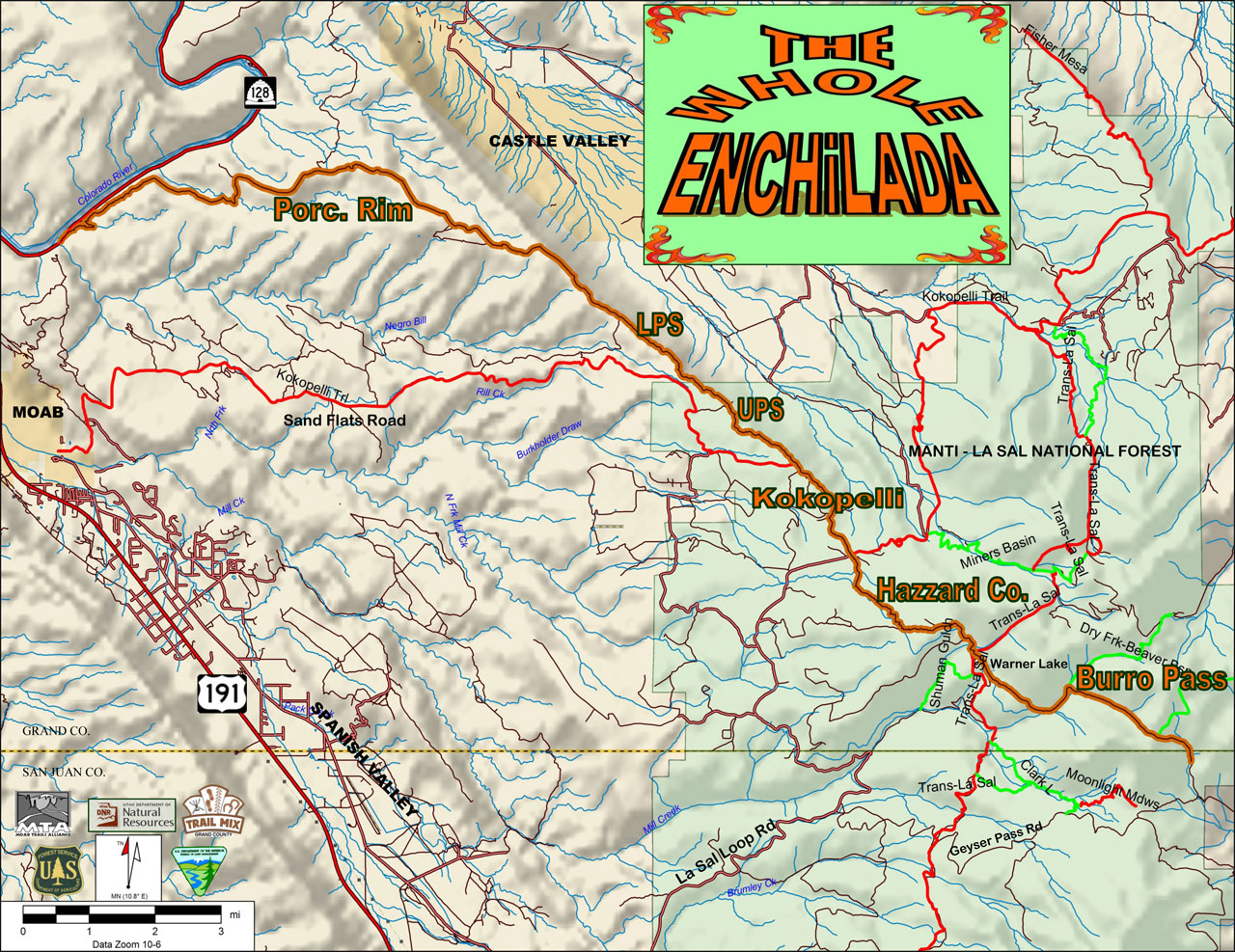
Whole Enchilada
Back to Top of ListThis trail system combines 6 trails to make an epic 25-mile downhill run from the La Sal Mountains to the Colorado River. Shuttles can be arranged at any of the bike shops in town. Please note that a day use fee applies when passing through the Sand Flats Recreation Area booth by shuttle or private vehicle to ride the Whole Enchilada, Porcupine Rim and LPS trails.

-
Length:
4.2 milesDifficulty:
Advanced riding skills required. Most difficult section of the Enchilada. Climbs approximately 700 feet to top of Burro Pass in less than 1 mile then descends 1860 feet in just over 2 miles. Average grade is 14%. Sections where the grade exceeds 20% are common. Check your brakes before attempting.Type of Ride:
1st ride of the Whole Enchilada. Ride is in forested mountain terrain. Starts at 10500 feet and tops out at 11216 feet. Tight switchbacks, loose igneous rock, creek crossings, exposed roots all challenge your technical skills. You can end this ride at Warner Lake or continue to the Hazzard County Trailhead to continue the Whole Enchilada. -
Length:
2.9 milesDifficulty:
Intermediate to advanced. All downhill except for the 1st half mile, which is a 200 ft climb. Average grade is 9%.Type of Ride:
2nd ride of the Whole Enchilada. Ride is through Aspen and Oak forest with occasional meadows. Fun and fast. Trail starts at Hazzard Trailhead off the Warner Lake Road and ends at the La Sal Loop Road -
Length:
1.8 milesDifficulty:
Two-track road section that drops about 550 feet to the beginning of the Upper Porcupine Singletrack (UPS). Dodging rocks, drainages and ruts in the road is the only difficulty. Average grade is 7%.Type of Ride:
3rd ride of the Whole Enchilada. Rocky road winding thru oak brush and pinyons. -
Length:
2.3 milesDifficulty:
Moderately challenging singletrack over rock, roots, ledges, and dry washes. Average grade is 6%.Type of Ride:
4th ride of the Whole Enchilada. Singletrack starts at a right fork off of the Kokopelli trail. Watch for the map sign. The double track, which is the Kokopelli, continues to the left and intersects the Sand Flats Road. UPS generally follows the rim on sandstone and dirt thru the Pinyons & Junipers. It passes thru a primitive campground where you can bailout on another road to Sand Flats. Continuing on the singletrack leads you to the start of LPS. -
Length:
1.8 miles staying along the rimDifficulty:
Technically challenging. Trail splits into a rim ride section and the Notch section. The Notch is for experts only. The rim ride section has an entry drop that is difficult and also for experts only. Most hoof it over these obstacles. Average grade is 11%.Type of Ride:
5th ride of the Whole Enchilada. Officially starts at the small cattle guard on the boundary between US Forest land and Bureau of Land Management land. The trail has numerous drops and slickrock to negotiate. -
Length:
11.5 milesDifficulty:
A fast but somewhat rough ride for advanced riders. Less skilled riders need more time to pick their way thru the numerous obstacles. Lower singletrack overlooking the Colorado River has several advanced technical sections. Average grade is 7%.Type of Ride:
6th and last ride of the Whole Enchilada. Starts where LPS ends at the Porcupine Rim 4×4 road. Turn right on this road and follow it along the rim. Turning left will take you back to the Sand Flats Road. Jeepers think this is one of the roughest 4×4 roads so take your time. Follow the signs at spur roads to make sure you continue on the Whole Enchilada. All the spurs are dead ends and a long way from help. Walk your bike through the extreme technical sections. The Enchilada ends at SR-128 (River Road).
La Sal Loop – Moab Front Recreation Area
The La Sal Loop – Moab Front Recreation Area is located in the La Sal Mountains, south of Moab. This recreation area provides many opportunities for mountain and road biking during the summer months, when temperatures are usually 20 degrees cooler than in the desert below. The La Sal Mountain Loop Road starts south of Moab, climbs up into the mountains and traverses the western side of the mountains to come out in Castle Valley. This area includes 3 campgrounds: Warner Lake, Oowah Lake, and Mason Draw. Perhaps one of the most photographed mountain ranges in Utah, the La Sal Mountains form a spectacular backdrop to the red rock features in the desert below.
Note: Due to the high elevation and steep nature of these mountain trails, most of them are difficult and require advanced mountain biking skills.
Areas for Mountain Biking at La Sal Loop – Moab Front Recreation Area
- Burlfriends Trail (family friendly – intermediate – for older teenagers)
- Burro Pass Trail
- Carpenter Basin Trail
- Clark Lake Loop Trail
- Clark Lake Trail
- Hazard County Trail
- Hell Canyon Trail
- Jimmy Keen Trail (family friendly – intermediate – for older teenagers)
- La Sal Pass
- Medicine Lake Trail
- Moonlight Meadows Trail
- Schuman/Shafer Creek Trail
- Squaw Springs Trail
- Upper Porcupine/Slickrock (UPS) Trail
- Warner Lake (family friendly – younger kids)
- Warner To Oowah Trail
- Whole Enchilada Trail
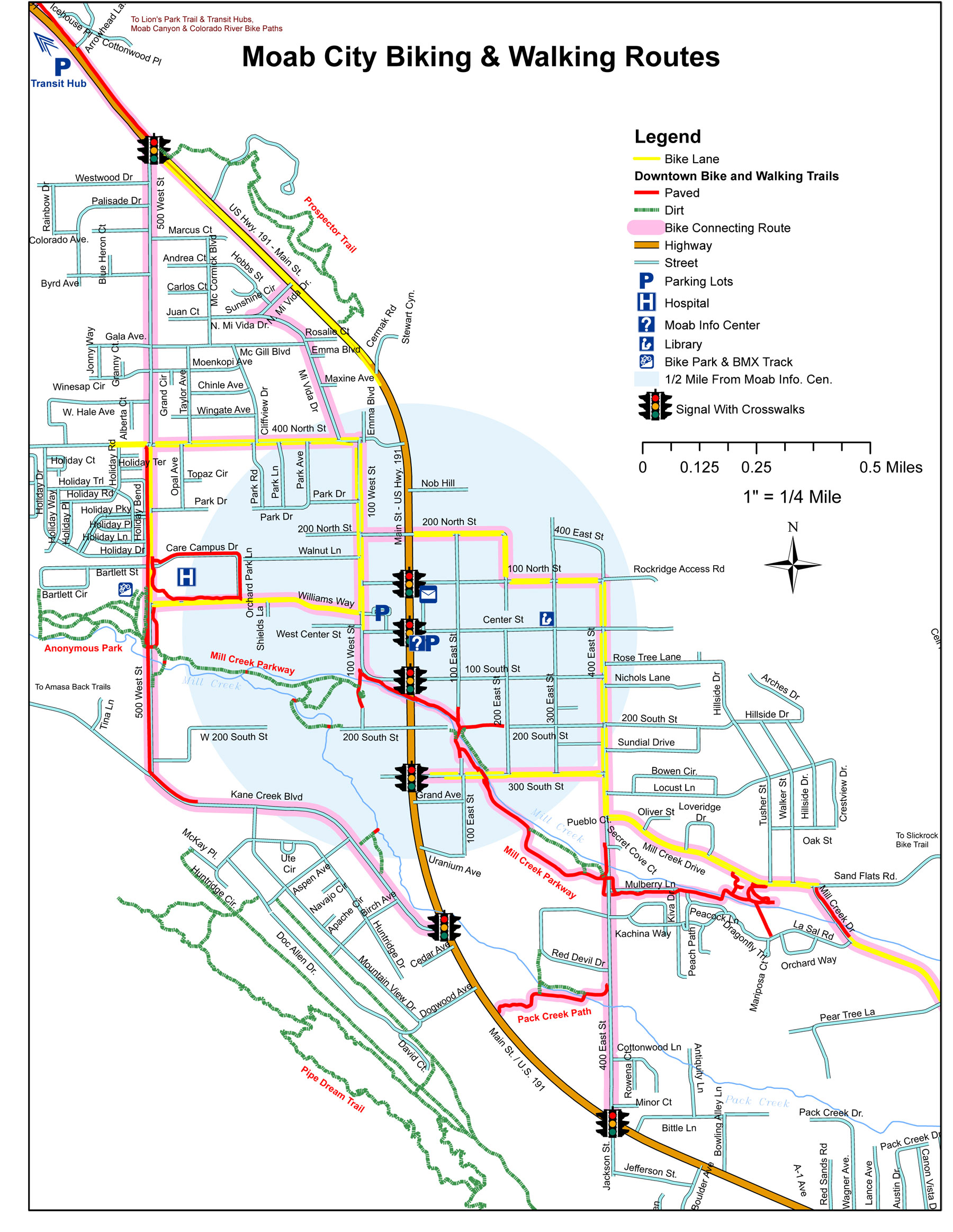
Bike Safety
The Moab area offers challenging riding amidst world-class scenery. The characteristics of the area that make it a special place for riding also make it extremely important to follow basic safety procedures. The Moab Bike Patrol has this to say:
Wear a helmet
Most trails are very rocky. Even the best riders can get tired and make mistakes. Helmets can prevent or reduce the severity of head injuries.
Carry lots of water and high-energy food.
At least a gallon of water is recommended per person per day. There is no water on the trails and summer temperatures often climb above 100 degrees Fahrenheit. Running out of water will put your health at risk. Eating at intervals provides an opportunity to rest and the energy needed to complete the ride.
Carry trail maps and know how to use them to track your position
Maps for Slickrock and Porcupine Rim trails are located at the trailheads and entrance station. Maps for 4WD roads are available at the entrance station. Detailed topographic maps are available in Moab at bike shops, bookstores and the Moab Information Center.
Stay found, save money.
Grand County has the highest incidence of search and rescue in Utah. The high cost of these operations is normally the responsibility of the rescued party. If you decide that you have lost the trail, do not continue on in hopes of finding your own way. Retrace your route back towards the trailhead until you pick up the trail, find someone who knows the area, or return to the trailhead. If you cannot retrace your route, stay put, conserve energy and water, make yourself visible and await rescue. It’s always a good idea to let a friend or relative know beforehand where you are going and when you should return. If something goes wrong you have the comfort of knowing that they will get help.
Check your bike frequently.
Riding in Moab trails loosens headsets and puts maximum stress upon frames and components. Frequent inspections reduce the possibility of injury. Be prepared in case of emergency.
Don’t venture into remote areas with nothing but a t-shirt and shorts.
Carry a windbreaker, sunscreen, sunglasses, maps, matches or lighter, pump, patch kit, first-aid kit, a good bike tool kit and extra food, water and clothing.
Ride with someone else and stay together in case of problems.
Discuss your situation calmly and make a plan to improve it.
Trail information courtesy of Geoff Freethey and Trail Mix.
Note: The information on this page is provided as a courtesy to area visitors. No warranty, expressed or implied, is made as to the safety or ongoing validity of this information. Grand County, Utah or its agents are not responsible for any liability arising from the use of the information presented here.