


Petroglyphs and Pictographs
Many of the petroglyph and pictographs in the Moab region were created thousands of years ago! Sites located on public land, including within the National Parks and on BLM land, are of national significance and are protected areas. The preservation of these fragile and beautiful remnants from the past is our responsibility, and we must exercise caution to ensure that future generations can marvel at them as well. If you happen to encounter petroglyphs, pictographs, and rock inscriptions during your travels around the Moab area, please observe the following precautions diligently:
Site Visiting Etiquette
- Don't make your own inscription! Inscriptions were made to tell stories and mark important locations; in modern times, we do that by taking photos and writing about your experience, instead of carving on rock faces.
- Don't touch the surface of the petroglyph, pictograph, or inscription: You could damage the surface. Scratching on or near inscriptions causes irreparable damage and is illegal.
- Don’t collect or disturb artifacts or features at a rock art site. It is acceptable to pick up surface artifacts, examine and enjoy them, or make sketches or take photos of them, as long as they’re returned to the place where found, and no damage is done to the artifact.
- Please remember that many living people consider these sites sacred.
- Speak out when needed to prevent damage to rock art. Report new rock art destruction, charcoal near the site, or site vandalism to the Archaeological Resources Protection Act hotline @ 1-800-227-7286.
-
Continue on Kane Creek Drive past the cattle guard, where the road turns from pavement to graded gravel road. After traveling 1.7 miles from the previous site, or a total of 5.3 miles from the intersection of Kane Creek Drive and 500 West, you will see two small pullouts suitable for single vehicles. If you are traveling with a large group, continue up the hill where more parking space is available and walk back to the site. Approximately 75 feet west and down the slope from the road, is a large boulder with rock art on all four sides. Figures and designs range from the Formative to the historic Ute period. The well known “birthing scene” is found on the left‑hand corner of the east side A the boulder (facing the road). Notice the feet-first presentation of the baby. Look for various animal forms, such as a centipede and a horse, bear paws and a snake, as well as triangular anthropomorphic (human) figures and a sandal trackway.
-
Drive north from Moab on Highway 191 and cross the Colorado River Bridge. Proceed .5 miles to a parking area on the right side of the road. Walk back across the small bridge that crosses Courthouse Wash on the graveled foot path. At the east end of the bridge, face the 11:00 position and look up at the cliffs. Walk uphill to the base of those cliffs and look for an extremely faint rock art panel. The panel consists of a large pictograph and petroglyph panel along with associated petroglyphs on the rock slabs at its base. The panel is approximately 19 feet high by 52 feet long. The site, located in Arches National Park, was heavily vandalized in 1980, but conservation work has helped preserve and stabilize the site. You will see large painted ghost-like illustrations typical of the Barrier Canyon Style Archaic figures on the red-orange surface. The numerous figures include human forms, bighorn sheep, shields, scorpion-like illustrations, possible dogs, a long beaked bird and abstract elements. You can see evidence of painted multi-colored figures superimposed on other pictographs. On the desert varnish surface you will see human and animal like figures as well as abstract forms. This site is on the National Register of Historic Places because of its representation of a Barrier Canyon Style rock art panel.
-
Take Highway 191 south to the golf course turn off (approximately 4 miles from the comer of Main and Center in downtown Moab). Turn left and proceed to Spanish Trail Road approximately 1 mile just past the fire station located on the left-hand side of the road, turn right onto Westwater Drive. Proceed.5 miles to a small pullout on the left-hand side of the road (please do not block or go up the private driveway). The panel runs from ground level up to approximately 30 feet on the high rock wall. Designs cover an area about 90 feet wide. The panel is from the Formative Period and you will be able to see human figures, such as the “Moab Man”, elk, canines, and big and small bighorn sheep. Look to the far right of the panel and find what is popularly referred to as the reindeer and sled.
-
At the comer of Main and Kane Creek Drive (McDonald’s is on the southwest corner) turn west and proceed .8 miles to the intersection of Kane Creek Drive and 500 West. Stay left and continue along Kane Creek Drive approximately 2.3 miles to the mouth of “Moon Flower Canyon. Along the rock cliff just beyond the canyon, you will see a rock art panel dating from he Archaic to Formative Periods. The site is behind the tall protective fence. There is a Barrier Canyon Style figure (a large triangular shape with headdress), desert, bighorn sheep and a number of abstract elements. The panel is from ground level to a height of about twelve feet and extending approximately 100 feet. You will see a blue residue left from an illegal latex mold on one of the bighorn sheep motifs. This entire panel is one of the most vandalized rock art sites in the Moab area. Continue another 1.2 miles to another rock art panel. A huge rock surface covered with desert varnish faces the river from the cliff side of the road. Here, you can see bighorn sheep, snakes, human forms, and a trail, possibly indicating a route from the river up Kane Springs Canyon. Again, you will notice some vandalism. (If you miss this site, it may be seen more easily on the return trip.)
-
From Highway 191 take Utah Scenic Byway 279 (Potash Road) south for 5 miles where you will find an “Indian Writing” interpretive road sign and pull out adjacent to the river. Caution: Watch for highway traffic. Looking 25 to 30 feet up the rock wall on the cliff side of the road you will see petroglyphs from the Formative Period. Look for the line of “paper doll cutouts” and horned anthropomorphs holding shields and abstract images, as well as a wide variety of other animal and abstract images. The panel extends along the road 125 feet. The round holes carved into the sandstone underneath the left side of the petroglyph panel once held the roof poles of a structure which was excavated by archaeologists prior to road construction. The structure and the rock art panel were easily accessible before the talus slope was cleared away to make room for the road. Continue south 200 yards to the next “Indian Writing” sign. You will find the large bear with a hunter at the bear’s nose and another over its back. At an interpretive pullout approximately 0.75 miles further along the Utah Scenic Byway 279, you can see Indian rock art and dinosaur tracks. On the north side of the road two spotting tubes indicate the location of three‑toed allosaurus tracks in the Navajo/Kayenta sandstone interface. Binoculars are needed to view the petroglyphs located to the left of the tracks at the base of the cliff. Approximately 7.5 miles farther along Highway 279 is Jug Handle Arch (near the mouth of Long Canyon). Proceed to jug Handle parking area via a dirt road that travels east from the highway. The rock art is located above the parking area to the north.
-
Take Hwy 191 north to Interstate 70. Go east to the Thompson Spring exit. Travel north through the small town of Thompson Springs to the area preserving the rock art panel with split rail fences. Rock Art is meant to be looked at, take pictures, and please do not add any scratches or marks to any stone surface, fence, nor building walls in the great outdoors. Bring water and a lunch along! Picnic tables and pit toilet are available at the site. This outdoor gallery has pictographs and petroglyphs and covers Native American people over 8,000 years. The haunting figures resemble those in Canyonlands National Park’s Horse Canyon Great Gallery and are of the time period of the Archaic Period 6,000 BC to 100 BC. Besides the painted Barrier Canyon Style, the Fremont etched triangular bodies and square heads highly decorated. The Fremont were named after the Fremont River in Utah and lived at the same time as the Anasazi beginning around 600 AD through about 1250 AD. Then the Ute, 1300 AD until 1880 AD, inhabited the Sego Canyon. This un-united group traveled in nomadic bands. The art is dated by the arrival of the horse with the Spanish in the sixteenth century and reference to circles believed to be shields. By 1880 the Ute were forced onto reservations.
-
Located in Arches National Park, the Wolfe Ranch panel is a fine example of historic Ute rock art. Follow the signs to Wolfe Ranch and Delicate Arch, 14 miles from the park entrance. At the Wolfe Ranch parking lot, walk east 600 ft. along the established trail past the cabin and across the wash. The Ute hunting panel site is on a trail that branches left off the Delicate Arch trail just past the bridged wash.
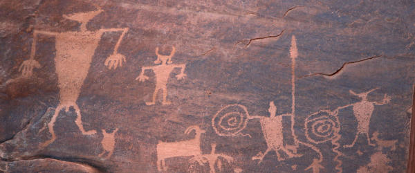
Petroglyphs In Southeast Utah
This is canyon country, a landscape defined by the forces of nature that have carved their way through the red sandstone for millions of years and still continue to perform their work. The human…
![Newspaper Rock [Moab Museum Collection, Elaine Peterson Collection]](https://assets.simpleviewinc.com/simpleview/image/upload/c_fill,f_avif,fl_strip_profile,h_500,q_65,w_700/v1/clients/grandcountyut/Screenshot_2024_11_19_141453_5af82bd2-170c-4e9e-8e61-1718032970a4.png)