

Pinto Arch Trail
- Difficulty
- Moderate
- Distance
- 2.1 ml
- Duration
- 2 hr
- Ascent
- 469 ft
- Descent
- 469 ft
Highlights:
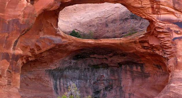
Although a short trail, hikers are treated with several large alcoves containing hanging gardens, as well as scenic views of the Colorado River coursing its way through the canyon 500 feet below. At the trail’s end you can stand under the attractive Pinto Arch with its 30-foot span. The trail can also be combined with the popular Corona Arch Trail.
Description:
Access to the first trail spur going to Pinto Arch occurs a half mile along the Corona Arch Trail. As it starts, most of the trail is on slickrock rather than sand, before transitioning entirely to slickrock for the last half mile of the hike to the arch. The trail works its way across slickrock toward several large Navajo Sandstone alcoves. As it nears the alcoves the trail makes a short climb to get up to the bench below the alcoves. Then it easily climbs up other stone benches for a couple hundred yards before Pinto Arch comes into view. The rest of the route to the arch is plainly evident. Hikers only interested in going to Pinto Arch will take the same route back to the Corona Arch Trail and parking lot. Alternatively, hikers continuing on to Corona Arch can take a second 0.12 mile spur that rejoins the Corona Arch Trail a tenth of a mile above the first spur. Hikers returning from Corona Arch that wish to continue on to Pinto Arch would also be able to use this spur to connect to the main Pinto Arch Trail. Creating the Pinto Arch Trail as a designated trail creates its own scenic destination, but also offers stronger hikers going to Bow-Tie and Corona Arches an extension to their hike length, and the benefit of seeing a third great arch up close. On SR 279, 10 miles west of the SR 279/US Highway 191 junction. This is the same starting point for the Corona Arch Trail.