


E-Bike Guide to Moab
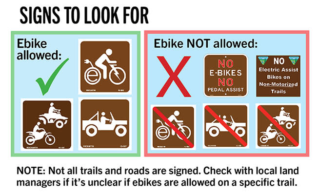
The Moab area offers hundreds of miles of excellent riding for e-bikes! Read on for rules and regulations concerning Class 1 e-bikes. All other e-bikes are allowed only on motorized trails. If you have more specific questions, we encourage you to reach out to our talented local bike shops.
In town:
- All e-bikes are welcome on all surface streets, and within on-street bike lanes.
- All e-bikes are welcome on all open motorized trails.
- Class 1 e-bikes are allowed on the City’s path systems, including the Mill Creek Pathway, with a speed limit of 15 miles per hour.
- Class 1 e-bikes are allowed on the non-motorized Moab Canyon pathway.
BLM
All e-bikes are allowed on all open motorized roads and motorized trails.
Class 1 e-bikes are allowed on the following trails:
- Athena Mountain Bike Trail
- Horsethief Mountain Bike Trail System
- Navajo Rocks Mountain Bike Trail System
- Gemini Bridges Area Mountain Bike Trail System
- 7-Up Mountain Bike Trail
- Gold Bar Rim Mountain Bike Trail
- Portal Mountain Bike Trail
- Klondike Bluffs Mountain Bike Trail System
- Baby Steps Mountain Bike Trail
- Klonzo Mountain Bike Trail System
- Moab Brands Mountain Bike Trail System
- Amasa Back Mountain Bike Trail System
- Jackson Mountain Bike Trail
- Hunter Canyon Rim Mountain Bike Trail
- Pipe Dream Mountain Bike Trail
- Raptor Route Mountain Bike Trails: Hawks Glide, Falcon Flow, Kestrel Run
- Kokopelli Mountain Bike Trail – 1.7 mile of non-motorized singletrack trail
Arches and Canyonlands National Parks
- All e-bikes are allowed anywhere a regular bicycle is.
- However, there are no singletrack trails open to bicycles in either park.
Dead Horse State Park
- Class 1 e-bikes are allowed on trails open to regular bicycles.
US Forest Service
- All e-bikes are allowed on all open motorized roads and motorized trails.
- All e-bikes are considered motorized vehicles. (36 CFR 212.1)
- All e-bike use is prohibited on all non-motorized trails.
Where to Ride
Dead Horse Point State Park - Beginner!
- Beginner – Intermediate singletrack
- 19+ miles of singletrack – many loop options
With the most iconic Moab views, and fun purpose built singletrack this is a must do. Entry fee is required, map included upon entry of park.
Visitor Center Phone: 435-259-2614
Website: stateparks.utah.gov/parks/dead-horse/
Sand Flats Recreation Area, Slickrock Bike Trail - Expert!
- Advanced singletrack entirely on sandstone.
- 15+ miles – many loop options
One of the most unique experiences you will ever have on two wheels. Other great options within Sand Flats include Hells Revenge and Fins and Things. Fee required at booth, map included upon entry.
Phone: 435-259-2444
Website: sandflats.org
Other Trail Adventures
Flat Iron Mesa
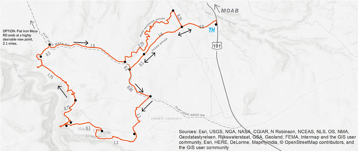
Background
- 15.23 miles – Lollipop loop
- 1,352’ elevation gain
- Difficulty: Intermediate/Advanced – Beginner option, out and back
- Mix of loose and hard-packed doubletrack with advanced options.
- Additional info: mtbproject.com/trail/7036624/flat-iron-mesa-loop
Description
If an escape from the crowds and scenic landscapes are what you’re looking for, this is the ride for you. You’ll be following along the top of a canyon with steep walls comprised of the Wingate sandstone formation. Many of Moab’s most scenic viewpoints are on this route.
From trailhead (TH), follow the 4X4 road north, parallel the highway into a wash, once in the wash the road turns left (west) and climbs out of the wash. Continue on this road west for 2.1 miles. At the T intersection turn left, and follow Flat Iron Mesa Rd. for 0.85 miles, turn right onto the Flat Iron Mesa 4×4 route signed with “FI” on signposts. From here, the trail makes a loop heading south, turning west, then heading north along the rim of Hatch Wash.
After 6.2 miles on the Flat Iron 4×4 route, you’ll intersect Flat Iron Mesa Rd. once again.
OPTION: Turning left, and continuing for 2.1 miles, northwest will take you to the end of Flat Iron Mesa Rd and a stunning overlook of the confluence of Kane Creek Canyon and Hatch Wash Canyon.
To return to the trailhead, turn right (southeast) and continue for 1.8 miles on Flat Iron Mesa Rd. to the first road you pedaled out on. Turn left (east) and follow the road back to the trailhead.
ADVANCED OPTION: Turn left after 1.6 miles for an added 2.25 miles on an advanced 4×4 road. After 2.25 miles, turn right (south) on the Gas Line Rd. and continue for 0.35 miles. Turn left (east) to return to the TH.
BEGINNER OPTION ROUTE: Start the route from the same Trailhead, but once to Flat Iron Mesa Road, turn right (north) and continue for 4.3 miles to the end of the road at Kane Creek Overlook. The return route is reversed.
Access
From Center St. and Main St. in Moab, drive south on Highway 191 for 18 miles. Just after crossing over Mule Shoe Canyon, turn right and park at the entrance of the 4×4 road.
Note: This trailhead is not signed along HWY 191. If struggling to find TH, you can start the route on Flat Iron Mesa Rd at its intersection with HWY191
Seven Mile Rim
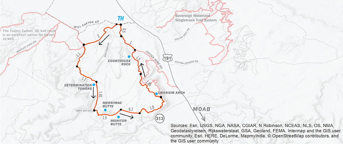
Background
- 15.15 miles – Loop
- 1,490’ elevation gain
- Difficulty: Intermediate
- 4×4 doubletrack with mixed packed, slickrock, and sandy stretches.
- Open desert with scenic views of large sandstone mesas
- Additional Info: mtbproject.com/trail/7036625/seven-mile-rim-loop
Description
The Seven Mile Rim route takes you through the rolling slickrock canyons of Tusher Canyon, past the tall desert towers of Determination Towers, along and between Monitor and Merrimac buttes, climbs Seven Mile Rim to a stunning view looking out into Arches National Park and the La Sal Mountains, before descending past Uranium Arch and Courthouse Rock back to the Trailhead. Use caution as this area has many alternative roads. Carry proper equipment for navigation.
From trailhead (TH), ride west for 0.1 mile, turn left and follow signs labeled 7R from here. Continue 2 miles to intersection of Tusher Canyon Rd., turn left (south). Continue up the canyon for 1.1 miles. Turn left (east), following signs marked “7R” and “M&M”. After 1.2 miles you will leave Tusher Canyon, and see Determination Towers to your south, turn right at this intersection following the sign to “7R”. Traveling south, past the Determination Towers, continue for 1.45 miles. You’re now at a strange four way intersection near Wipeout Hill, and just west of the Merrimac Butte.
Take the second left that heads to the south side of the Merrimac Butte. Continue east around the southern base of the Merrimac Butte for 1 mile. Continue through the middle of the two buttes, heading northeast, for 0.5 mile. Turn right (east), and continue straight for 0.7 mile, this stretch will have a few roads intersecting your path, however, continue straight until the T intersection. At T, turn left (north), in approximately 1500 feet stay right and continue on this road east, for 1.9 miles. This road primarily climbs east then turns north near the top of Seven Mile Rim. After 1.9 miles, turn left (west), to descend 0.3 mile to Uranium Arch. Once past the arch, continue north on roads marked “M&M” or “HWY 191” for 3.1 miles. Your final slickrock descent will take you past the east side of Courthouse Rock before intersecting the Cotter Mine Road. Turn left (northwest), on Cotter Mine Rd and continue for 1.5 miles to the Trailhead. There are many alternative roads in this last 3 mile section. By continuing north you will make your way to the Cotter Mine Road.
Access
From Center St. and Main St. in Moab, drive north on Highway 191 for 16 miles. Turn left onto Mill Canyon Rd. and proceed for 0.6 miles to the Mill Canyon, Tusher Canyon Trailhead.
Note: Tusher Canyon (west side of loop), during dry periods of the year can be difficult on an ebike with narrower tires due to sand. If on an ebike with tires narrower than 2.5”, riding this route in the opposite direction is advised.
E-bikes And Other Users
E-Bikes on Shared Use Trails
- Stop for cyclists, hikers, runners and horseback riders.
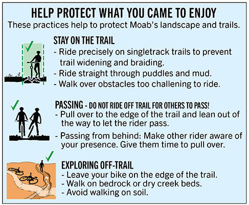
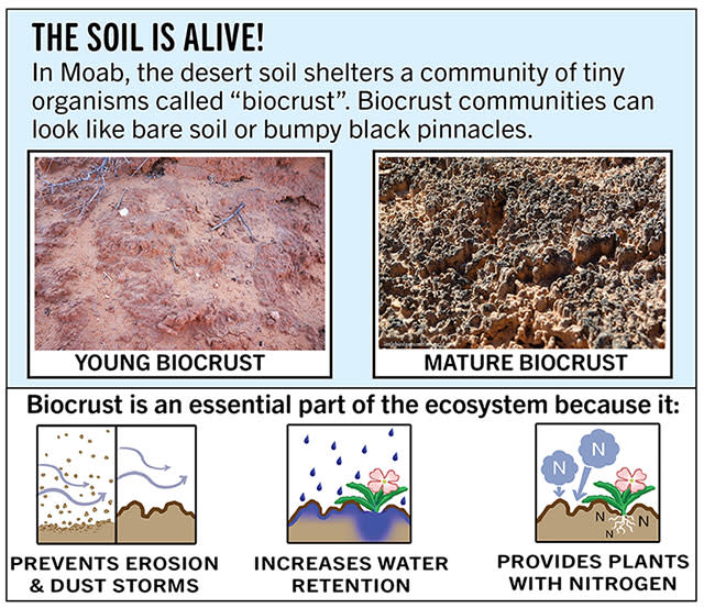
- STAY ON THE TRAIL – Ride to the edge of the trails surface and lean out away from the other rider to protect sensitive biological crusts. Do not ride off trail to get out of the way!
- Passing from behind, alert the other rider of your presence, slow down, and give them time to pull over in an appropriate spot. Be patient, don’t rush them.
- When passing other users on a road, slow down and announce your presence before passing.
- When riding around blind corners, always slow down and anticipate other users.
E-Bikes and Horseback Riders
- Always announce yourself from a long distance before approaching an equestrian.
- Once the rider acknowledges you, they will give instructions on how to proceed past.
- Never pass a horseback rider unexpectedly as this can startle the horse and cause injury to the rider.
E-Bikes and Other Motorized Users
- Yield to one another and stop as appropriate.
- Pull over only in wide areas like washes or on rock.
- When encountering a 4×4 vehicle driving up or down ledges or on steep loose surfaces, get the driver’s attention before attempting to pass and signal how many more are coming.
- You are on a maneuverable machine; be courteous and yield right of way to larger vehicles.
Local Knowledge
Be Prepared
- Make sure your e-bike battery is fully charged.
- Carry tools to fix mechanical breakdowns.
- Have at least one gallon of water per person per day, extra food, and appropriate clothing for unexpected weather conditions.
- Let someone know where you are going before heading out, carry maps for the area you are planning of going.
- Cell phone coverage is limited outside of the Moab Valley; do not rely solely on your cell phone for navigation or rescue.
Desert Trail Conditions
Moab trails feature steep sandstone and stretches of sand that can drain your battery faster than riding on hard-packed trails. Plan your mileage with this in mind. Keep a close eye on your battery consumption, and adjust your ride and power settings accordingly.
Navigation
Know your route and bring accurate maps. The most accurate and frequently updated maps for the Moab area are the Latitude 40, Moab East and Moab West maps, and National Geographic North and South Moab maps. These maps have the most accurate road and trail info and also highlight popular OHV routes that are great for e-bikes. Do not rely solely on the information on this page for navigation.
Desert Weather
Always plan for adverse, changing conditions. Flash floods can affect most the trails in the area leaving you on the wrong side of a creek for minutes or hours.
Desert weather can be unpredictable. Fast moving thunder and lightning storms, along with heavy rains and even unexpected snow showers can hit with little notice.
High daily temperatures in summer months (June-August) are consistently over 100 degrees Fahrenheit (38 Celsius). Heat stroke and heat exhaustion are common in summer months. To help avoid this life threatening issue, ride in the early morning or in the evening and rest during the hottest part of the day.
Practice Minimum Impact
E-bikes have more power than traditional mountain bikes, are lighter than motorcycles and seem capable of going just about anywhere. It is the rider’s responsibility to respect the desert and the laws of our public lands to preserve our right to enjoy them into the future. Limiting your impact reduces the amount of maintenance required to keep trails open. Stay precisely on the designated routes and don’t widen or ride off the trail for any reason. Respect trail signage, info kiosks, and other amenities found at trailheads.
Pack It In, Pack It Out
Decomposition in the desert is slow. Please pack out all trash, including garbage, food waste, and especially human waste and toilet paper! Trash does not disappear, other humans must remove it.
Human Waste in the Desert
- Pack it out! Grand County requires you to pack out all human waste (Poo and toilet paper) from public lands.
- Wag bags are available from local gear stores and are the most sanitary system of disposal
Information courtesy of Moab Trail Mix.