Winter Activities in Moab

Introduction
Located within the Manti-La Sal National Forest, the La Sals offer many
areas open to cross-country skiing, sledding and a small amount of snowmobiling.
Access to most areas is off the Geyser Pass Road which is plowed to a parking
lot. For skiers, the LaSals offer both worked trails and backcountry terrain.
Some of these same areas are shared by snowmobile users, although some
restrictions apply.
Winter backcountry users should call 435-259-SNOW, November through April,
for current taped information on mountain weather, road conditions and
avalanche potential. The steep La Sal Mountains have a greater potential
for avalanche than the mountains of northern Utah, so please use caution
and common sense. Guided day and overnight ski tours, and ski rentals are
available in Moab.
Ski Trail and Backcountry Access
Access to the mountains is provided by two routes:
La Sal Mountain Loop Road
The La Sal Mountain Loop Road
is plowed regularly to the Geyser Pass road turn-off and somewhat less
frequently to Castle Valley. The Geyser Pass road is kept open to the restrooms
and parking area at 9,600 feet. (Note: Four wheel drive or chains may be
required on Geyser Pass Road since the snowplows leave a few inches of
snow to protect the road. ) The snowpacked road to the pass and on to Dark
Canyon Lake on the other side is a popular area for sledding, cross-country
skiing, snowshoeing and snowmobiling. The road also provides access to
backcountry skiing and snow-boarding in the Mt. Tomasaki and Gold Basin
areas. Snowmobiles are not allowed to leave the road in Gold Basin. Please
respect this closure of the most popular skiing area of the La Sals--the
rest of the entire range is wide open to you!
Old La Sal
From near Old LaSal at the south end of the
range - the road is plowed regularly to the stock pens near Dark Canyon
Lake and on up to Geyser Pass fairly frequently.

Cross Country Skiing
The LaSal Mountains offer miles of trails and unlimited backcountry skiing
terrain. The groomed trails pass by several meadows, some steep enough
for telemarking. They also lead to high terrain where experienced backcountry
explorers and mountaineers can find long descents equal to any in Utah!

La Sal Mountain Ski Trails
The Trailhead
Open meadows near the trailhead are perfect
for practicing. Please stay off the road and avoid sliding onto the road.
Sharp curves and snow banks obscure drivers' views of human bodies hurtling
downhill toward them.
Beginner's Meadow
This is a great place to practice skiing
and enjoy the scenery. It can be found 1/4 mile uphill from the trailhead.
The Junction
This area is located one mile from the trailhead.
The right fork, the Gold Basin Trail, extends to the Laurel and Gold Basin
areas. The left fork continues for 2.5 miles to Geyser Pass.
Note: The following route descriptions provide only
general directions and locations. There are no marked routes off the
main trails and many of the areas require route-finding skills. Consult
the topographic maps listed in the "Additional Information" section
at the bottom of this page to determine specific routes.
- Laurel Meadow - This trail offers telemarking for all levels
of ability. To reach it, the Gold Basin trail rises gently for 0.9 mile
from the Junction to Laurel Pass. At Laurel Pass turn left heading southeast
and meander through a series of meadows to a wide, 15‑25 degree south
facing slope, Laurel Meadow. The views of the peaks are spectacular.
Regardless of conditions, turning is usually good somewhere nearby. You
can return the way you came, or drop down through aspens spaced widely
enough for quick turns. At the bottom, turn right for a few hundred yards
and rejoin the Gold Basin Trail.
- Julie's Glade - This is the place for backcountry telemarking.
Continue up and across Laurel Meadow. Enter the trees for a short southeast
jaunt to the top of Julie's Glade, paradise for the telemarker when conditions
are right. Julie's meanders down a delightful 30 degree slope for about
half a mile. At the bottom, you can rejoin the Gold Basin Trail and return
home or head back to the ridge for another run. Remember, this is high
backcountry terrain; beware of potential avalanche hazard.
- Gold Basin - This area provides backcountry touring and
mountaineering. Instead of turning left at Laurel Pass, go down to the
right onto Pole Worm Fence Meadow. It is a wonderful place to practice,
gaze at Canyon Country and watch the sun set. Look across the Moab Rim
at Behind the Rocks and Canyonlands National Park. The Henry Mountains,
96 miles away, seem close enough to touch. Gold Basin is a mile beyond
Laurel Pass, just below the end of the road. The trail continues for
another mile before steep cirques beckon experienced mountaineers. The
tour presents little hazard as long as you stay below timber line and
avoid steep slopes.
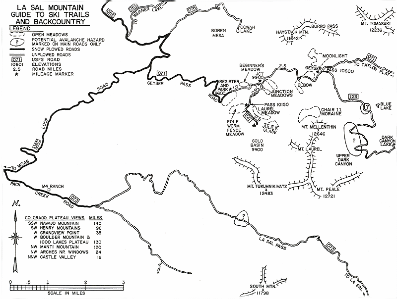
Geyser Pass is 2.5 miles from the
Junction, 3.5 miles from the trailhead and 1000 feet higher. There are
terrific touring and viewing opportunities along the way. The trail splits
at the pass. A Forest Service sign directs you to turn right for Dark Canyon.
The left hand trail skirts around the Northern group of peaks onto Taylor
Flat for many miles of open touring and snowmobiling.
- Chair 11 - This area gives you a look at mountaineering.
To access, head south at Geyser Pass, and climb to timberline below Mount
Mellenthin. You will find a series of moraines standing away from the
peak and its avalanche chutes Play on the moraines, or circle counter
clockwise around to the northwest side of the peak to Chair 11, a large
talus slope with a 25 degree angle. The Peak looms steeply above. Beware
of avalanche chutes. Venture up to the highest side of Chair 11 for breathtaking
views of Horse Canyon, Gold Basin, Mount Tukuhnikivatz, Mount Peale,
and a hundred miles of Canyon Country. Retrace your route back to Geyser
Pass. Do not try to find a short cut back to the junction. The forest
is thick, deep, dark and littered with deadfall.
- Moonlight Meadow - This is the place to watch the scenery
change as the sun goes down. Take the left trail at the Geyser Pass sign.
In 100 yards, turn left again (north) and travel a half mile to a medium
angle meadow facing the setting sun. The meadow is good for easy turns
if the snow is right. The view of Canyon Country is spectacularly framed
between Haystack Peak and Brumley Ridge. Take extra clothes and a light
stove. Brew some tea, stay for the sunset and ski in the moonlight.
- Dark Canyon - Offers isolated backcountry and mountaineering.
The Dark Canyon trail skirts to the right (east) from Geyser Pass around
Mount Mellenthin and into Dark Canyon, a place of sheer cliffs. The terrain
is remarkably similar to the High Uintas until you look at the red canyons,
Paradox Basin and the San Juan Mountains to the south and east. Be wary
of potential avalanche hazard. See Map.
Mountain Huts
If you would like to spend a couple of days up in the mountains, the La
Sal Mountain Hut System is the perfect solution. These 3 rustic cabins
(with cooking and dining facilities) allow you to spend more time skiing
in the mountains, rather than driving back and forth from town. The hut
operators can even snowcat your supplies and camping gear up to the huts
so you can spend more of your day enjoying the outdoors! The hut operators
can reached at (800) 453-3292 or (435) 259-8946.
Sledding
Sledding enthusiasts will find many areas suitable for sledding. Heading
up to the Geyser Pass parking area is a good bet for finding some enjoyable
sledding areas.
Snowmobiles
Snowmobiles are allowed on many of the same trails used by skiers. The
maps on this page show only a fraction of the many roads providing long
tours for snowmobiles on the east side of the mountains. Explore to find
the ones you like best, but when snow is scarce make sure you stay on good
snow-cover to avoid vegetation damage. Note that the area bounded by the
Gold Basin Trail, Mt. Tukuhnikivatz, Mt. Mellenthin, Geyser Pass and Geyser
Pass Trail is closed to snowmobiles. |
Detailed Maps

Once you arrive in Moab, detailed trail maps and guides
are available for sale at the Moab Information
Center (MIC).
Located in the center of Moab, on Main & Center Street, the MIC staff
is always happy to assist you.
GPS - Moab Info Ctr
Lat/Long
(WGS84)
38° 34' 22.4" N
109° 33' 0.1" W
Mail Order
Detailed trail maps and guides may also be purchased online from the Canyonlands Natural History Association, the company that stocks the information center. They can be reached on the internet at cnha.org or at 800-840-8978.
Suggested Maps
The following topographic maps can be useful for venturing
into the backcountry:
15" Series 1:62,500
Scale - La Sal Junction, Castle Valley, La Sal, Polar Mesa
7.5' Series 1:24,000 Scale - Warner Lake, Mt. Peale, La
Sal East, Mt. Waas, Mt. Tukuhnikivatz, La Sal West
Metric Series 1:100,000 Scale - La Sal
Forest Service Contact info
Manti-La Sal National Forest
Moab Ranger District
435-259-7155
Avalanches
The steep La Sal Mountains have a greater potential for avalanche
than the mountains of northern Utah, so please use caution and common sense.
Winter backcountry users should call 435-259-SNOW, November through April,
for current taped information on mountain weather, road conditions and
avalanche potential.
Avalanche
Website
|