
- Attractions
- Activities
- Lodging + Campgrounds
- Area Info
- Services
- Transportation

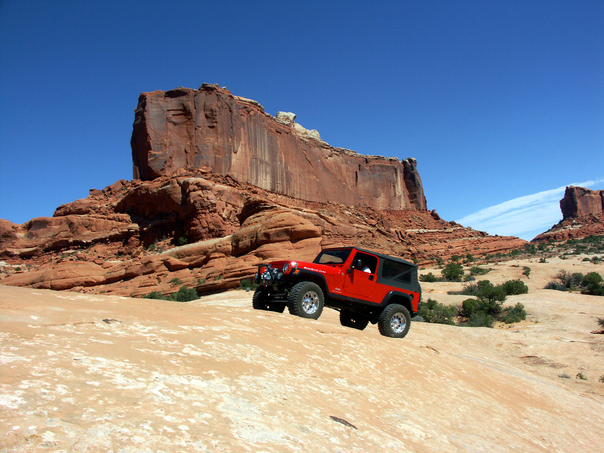
Moab 4-Wheeling
Moab is a must visit destination for those who love scenic adventures.

The Moab area’s beauty, history, and, hundreds of miles of old mining roads and 4-wheel drive trails make it a place that will never be forgotten. Visitors can bring their own vehicle, rent a jeep, or take a tour with one of Moab’s experienced & permitted guides. Always remember that travel is limited to designated motorized routes only. Off-road travel is illegal.
Moab has a full range of backcountry trails, from easy 2-wheel drive backcountry scenic drives to the ultimate in challenging 4-wheel drive trails, providing an opportunity for all to experience the beauty and solitude of a backcountry adventure. Always obtain the most up-to-date information prior to departing for a trip, and be prepared. Remember, turning back is usually an option as well. Please choose your trail wisely, with honest appraisal of your equipment and experience in this terrain. Once you arrive in Moab, detailed 4-wheel drive maps and trail guides are available at the Moab Information Center (MIC), on the corner of Main & Center Streets. The MIC staff is always happy to assist you with your plans and provide information about current trail conditions.
The following trails were selected because they are close to Moab and short enough for a partial-day trip. Among the trails is a variety of scenery and a range of challenge to the off-highway abilities of vehicle and driver.
Difficulty
4-wheel driving difficulty is hard to describe objectively. Opinions vary, and an individual’s judgment may change considerably as they gain experience. The easiest of these trails is suitable for stock high-clearance four-wheel drive vehicles. The most difficult trails are barely passable to first-rate off-road equipment. The other trails are well within the capabilities of stock four-wheel-drive trucks and utility vehicles.
Trail Marking
The primitive nature of 4-wheel drive trails makes them hard to mark and keep marked. On some, routes are obscure, while on others, the roads are clear enough but the many unnamed junctions are confusing. Storms can alter roads and remove tracks, while vandals can spoil the markings. Nevertheless, a sign has been placed to identify each trail a short way into the trail. After that, routes and junctions are marked in ways appropriate for the terrain, wooden posts may have a “trail” sign, slickrock may have painted symbols, and most areas will have cairns -small rock piles-to show the route. Topographic maps provide additional help and add to the enjoyment of off-road travel.
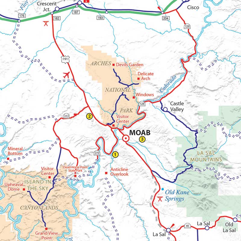
Map ID: 1
Round Trip from Moab: 54 miles
4-Wheel Drive Road: 43 miles
Minimum Time: 3-1/2 hours
Difficulty: Moderate
The route travels the Colorado River Canyon just below Moab, follows a spectacular part of Kane Springs Canyon, climbs the Kane Creek anticline to Hurrah Pass, and descends to benches above the Colorado River. The trail dead-ends at Chicken Corners about 400 feet above the river across from Dead Horse Point.
Trail Directions
From Main Street at Center Street in Moab, travel south on Main 6/10 mile, turn right on Kane Creek Boulevard, follow it through two sweeping curves past its junction with 500 West and continue into the river canyon. When the pavement ends near Kane Creek [0.0], continue on the good gravel road as it enters Kane Springs Canyon and follows the canyon meanders at various levels above the creek. Continue with the gravel road as it crosses the mouth of Hunter Canyon at a hiking trailhead [3.2].
Further along, the canyon broadens, and you can see Hurrah Pass on the right. The gravel road changes to dirt at the ford of Kane Creek [6.4]. Do not attempt to ford in high water; the water can be window-deep following storms or heavy spring melts. Beyond the ford, stay with the best-looking road as other trails leave to the left in the next half mile, and the road will bend toward the north and begin to ascend the cliffs below Anticline Overlook (note the safety fence on the cliff edge above). The summit of this climb is Hurrah Pass [10.0]. As the trail winds down the other side of the anticline, it shows more four-wheel-drive character.
The trail leaves the cliffs on a gentler slope and drops into a wash bottom. Continue straight (out of the wash) where a spur trail leaves to the right and follows the rough wash bottom [12.5]. Shortly after that, an optional route enters a small canyon to the left; the preferred route up the rocky slope to the right swings close to the river on a bench above it. Farther on, two trail junctions [14.4 and 14.6] leave to the left in view of a large side canyon and a mound of red rocks not far to the left of the trail. These trails go to the rock mound and its interesting catacomb caves. The main trail continues along the river benches, which are capped with fossil-bearing limestone, until it crosses a major wash [17.1]. (On the return trip, you will probably spot an unusual arch near the trail east of the wash crossing.) The trail you may see starting up this wash is the Lockhart Basin trail. You follow the main trail straight across the wash and follow along the benches as they wind higher above the water.
The point where the trail is pinched between rocks on the left and the abyss on the right [20.3] is “Chicken Corners” where Moab area guides were reputed to allow “chicken” passengers to walk, rather than ride, past the narrow, sloping section of trail. The trail continues along the broad bench until it narrows to an old horse trail [21.5]. You can’t go much farther, even on foot, because this is the start of a peninsula of land bounded by the gooseneck of the Colorado, the trademark of the spectacular view from Dead Horse Point. Return to Moab by the same route.
Map ID: 2
Round Trip from Moab: 48 miles
4-Wheel Drive Road: 14 miles
Minimum Time: 2-1/2 hours
Difficulty: Easy
The trail covers a region between US Highway 191 and SR 313, reaches some grand vistas, and accesses numerous other trails. The highlight is the spectacular twin arch, called Gemini Bridges, on the rim of an arm of Bull Canyon.
Trail Directions
From the center of Moab, travel north on US Highway 191 for 9.8 miles (you are still south of the SR 313 junction). Turn left to cross a cattle guard near an old ore car by the railroad tracks [0.0], cross the tracks, and turn left to follow the southerly dirt road paralleling the tracks. The main trail soon veers right toward the cliffs, and steadily climbs the cliff slope to Little Canyon, the gap in the cliff rim. Stay with the best maintained trail through upper Little Canyon (old mine trails leave left and right, and a strong spur trail leaves left into a side canyon). Turn right from the wash bottom area [4.8] to climb the steep dugway. The trail passes a gate and winds to higher levels, giving vistas in all directions. Stay with the main trail as spurs leave to the left, and fork right where the good left-hand trail leads to the lower levels of Bull Canyon [6.2] as it begins a sweeping bend to the right. This less-maintained trail is the older route; the graded road is not shown on many trail maps.
As the trail winds still higher, ignore two spur trails to the left and watch for the “Y”, junction that indicates that you are near Gemini Bridges. Keep left at the “Y” [7.4] and follow the markings; past visitors have left numerous unnecessary trails. As you approach the canyon, you will see the deep hole [7.8] that opens into the canyon wall leaving the twin spans. Return part way toward the “Y” junction, but take- the short-cut [8.0] to the left to join the main trail that was the right-hand fork of the “Y”. Turn left on this main trail [8.1], and turn right where a spur trail heads down to Crips Hole [9.0]. The trail joins the graded road that you were on earlier near a drill pad [9.7], and you travel the graded road westerly to paved SR 313 [13.8]. There, a right turn returns you to US Highway 191, while a left heads for Dead Horse Point State Park and the Island in the Sky District of Canyonlands National Park.
Map ID: 3
Round Trip from Moab: 20 miles
4-Wheel Drive Road: 9.4 miles
Minimum Time: 3 hours
Difficulty: Difficult
Fins and Things is a one-way trail. It starts 1.9 miles from the Sand Flats Entrance Station (5 miles from downtown Moab), beside campsite ‘E-6’ in Echo Campground. For trailer parking, please park prior to this on the south side of Sand Flats Road 1.4 miles from Entrance Station. OHVs are permitted on the Sand Flats Road. The trail is marked with metal signs and white symbols painted on the slickrock surface. Due to hazardous terrain, it is recommended only for experienced drivers.
The first section between the start and Fox Campgrounds is not recommended for ATVs. ATV users should pick up the trail on the Sand Flats Road at the Diving Board Rock formation which is 3.7 miles from the Entrance Station. A fee is required to enter the Sand Flats Recreation Area.
The Red Rock 4-Wheelers is a non-profit club organized to bring together adventure loving individuals and families who share the common interest of active four-wheeling. Their objective is to encourage family recreation through safe and responsible operation of four-wheel-drive vehicles. They also seek to utilize public lands in a responsible manner as part of an effort to keep public land trails and roads available for multipurpose use. The club organizes one of Moab’s largest events, the annual Easter Jeep Safari, which consists of trail rides, mostly day long trips, departing from Moab throughout the 9 day-long event.
The club’s website contains a fantastic reference to most of the 4-wheel drive trails in the Moab area. Visit their website here: rr4w.com.
Need somewhere to to park your vehicle or trailer overnight? Although the city of Moab does not have any public long-term parking areas, these companies provide safe, secure storage.
For a more optimal web experience, please view our site on Microsoft's recommended browser, Edge. You can download it here.